https://www.alertwildfire.org/region/shastamodoc/?camera=Axis-AntelopeYreka1
Not a good day or place for a fire…
https://www.alertwildfire.org/region/shastamodoc/?camera=Axis-AntelopeYreka1
Not a good day or place for a fire…
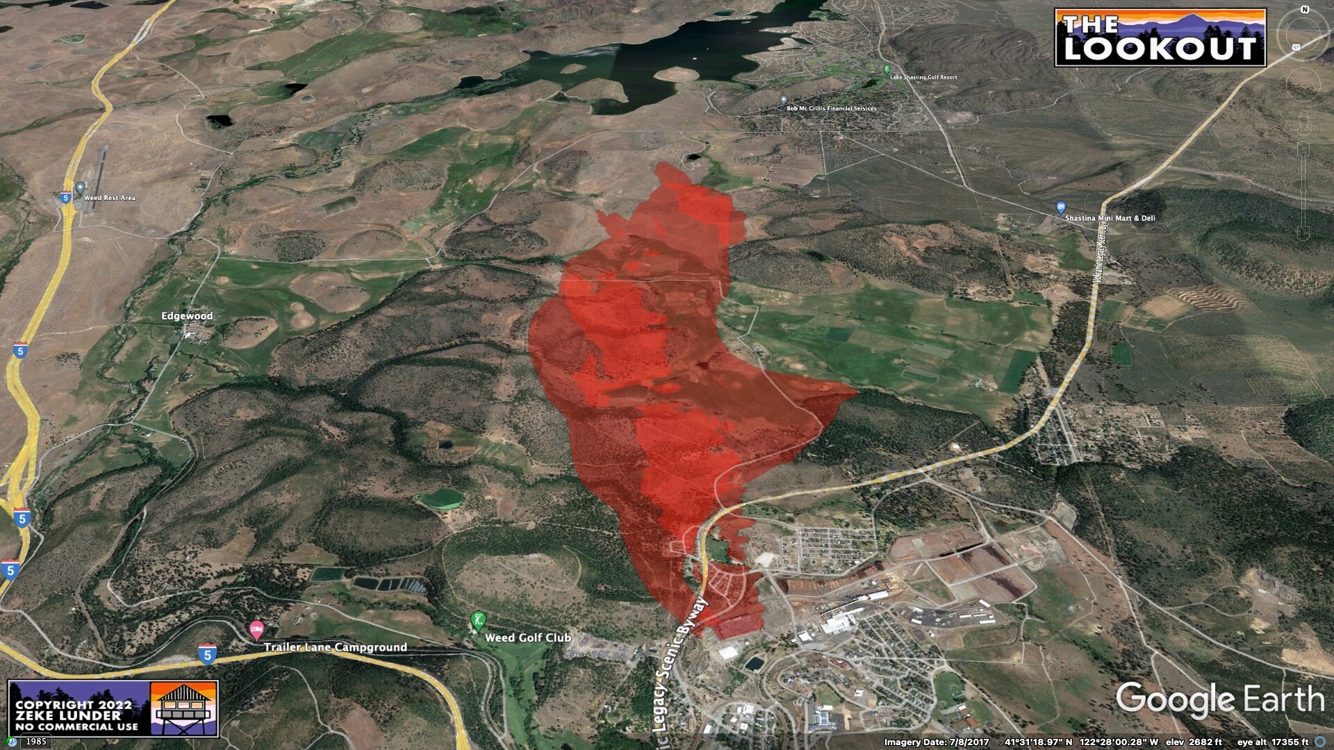
200 homes in Lincoln Heights threatened. Reported structures involved, the fire is 200 plus acres.
Requesting 15 Charlee strike teams
AA ordered 8 tankers 1 lead and 3 copters
Weather
strong SE winds
WX PGE North Weed 89F 16RH SE 17G15 (head of fire)
WX PGE SE Weed 86F 15RH ESE 11G23 (tail of fire)
Burning towards Lake Shastina area
Mods–Can you combine the 2 SKU-Mill threads, please.
Evac info
Everything S of Short Cut Rd/Lake Shastina
Everything E of I5
Everything W of Carrick
New CMD, CMD 10 Tone 2
Weed cameras have been offline 1254.
-MOD NOTE-
This thread is the IA for for info, The other is now the Q AND D for discussion of the fire.
The PGE North Weed WX station is now 4min overdue, in direct path of fire. Last at 110pm 88F 15RH SE 20G31
Edit - the 120pm reading just came in, really late.
Edit - still on 140pm, 89F 14Rh SE 17G27, per Sheriff, fire has reached Hoy Rd right near this station at 1340.
Fire is pushing towards Lake Shastina area.
With everything they have ahead of this fire, 15 strike teams is nowhere near enough.
NEU is just toning out an Immediate Need ST/E to the Mill. Best case, that’s about a 4 hour run.
I can already see fire on the lake shastina cam
https://beta.alertwildfire.org/region/shastamodoc/?camera=Axis-Weed
Weather update
Left shoulder
Weed Airport RAWS 97F 7RH SSE 23G33 (1 hour resolution)
Weed Airport Caltrans 96F 6RH SE 19G27 (little sheltered from wind down roadside, 15min resolution)
Head/Right Flank
PGE North Weed 90F 13RH SE 16G27 (inside the FIRIS perimeter)
Heel
PGE SE Weed 88F 14RH ESE 12G24
Something going in SHU/SKU, may be a structure but probably has potential to spread.
CAM…https://www.alertwildfire.org/region/shastamodoc/?camera=Axis-HammondRanch
This is the Mill in Weed, Woodridge Ct. obviously into the vegetation now.