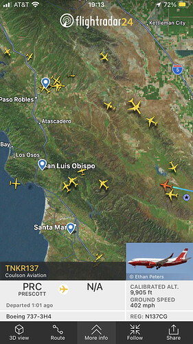
New start, with a well developing column, at Lopez Lake.
cameras are down. 
Based on the camera, it looks more like it’s closer to Pozo. Perhaps between the two, the lake and Pozo, off High Mountain Road.
Cuesta Peak Camera has some of the smoke. It’s dissipated a bit, but there is definitely a working fire.
Looks like Plowshare has a good/decent view. ALERT Wildfire
Also the LP’s wildcad has it at Lat/Long 35 11.196, -120 29.28, with a heavy run card.
Great angle. That could prove to be a rough fire.
Chances are, this is in the LP.
I know this area quite well. It is thick, continuous fuels and is in pretty arduous terrain.
The Lat/Long puts it at the S/SW side of Lopez Lake (almost on shore). However, flightradar has all the aircraft to the NE of the lake a ways. Looks like T74 and T75 are almost back to Paso. I’m only assuming load and return, as I don’t have a scanner for the fire up yet.
AA 340 seems to be orbiting in the vicinity of this location:
///neatest.countering.upbringing
which is ~ 35.244731, -120.38294
This is on the forest
All communication being switched to LPF forest net
5-7 acres in brush w/ slow-moderate ROS, potential for 50 acres. 2 addl handcrews, 3 addl type 3s. 2 addl tankers for a total of 3.
LPF: 10 acres, moderate ROS, on both sides of the road. 1 acre on the western side, 8-10 acres on the eastern side, potential for 100 acres.
Per AA - 15 acres. Also, “these next two drops will decide if we can hold it or not”.
Tankers are still working and it’s spotting ahead of itself some.
20 acres, still a potential for 100
Just about everywhere on the LP is arduous terrain…haha
Has it been requested for this incident or SLU-Eagle ?
This one. Eagle started while they were already in the air. I believe this A/C is on contract with the FS at this time.

