CA-SQF-Lightning 2024 (Trout/Long)

Here’s the update from team 14 from Kennedy Meadows fire station discussing the Trout and Long fires. Trout is now considered Branch I and Long is now considered Branch IV by team 14.

https://fb.watch/tqv0UT19BO/?mibextid=cr9u03

Towards the end of the stream they discuss the difference of fuel load/ fire behavior from the Manter Fire.

Overnight IR map from 18 July

7 Likes

8 Likes

Long Fire: 8,661 acres - 0% containment
Trout Fire: 10,489 acres - 0% containment

2024 SQF Lightning Daily Incident Update_07-19-2024_Final.pdf (150.5 KB)

3 Likes
4 Likes

Why am I getting nightmares of the “Manter” fire once again?

8 Likes

2024 SQF Lightning: Daily Incident Update (07-20-2024)

Video: https://fb.watch/trU34e_ZZz/?mibextid=0VwfS7&fs=e&s=TIeQ9V

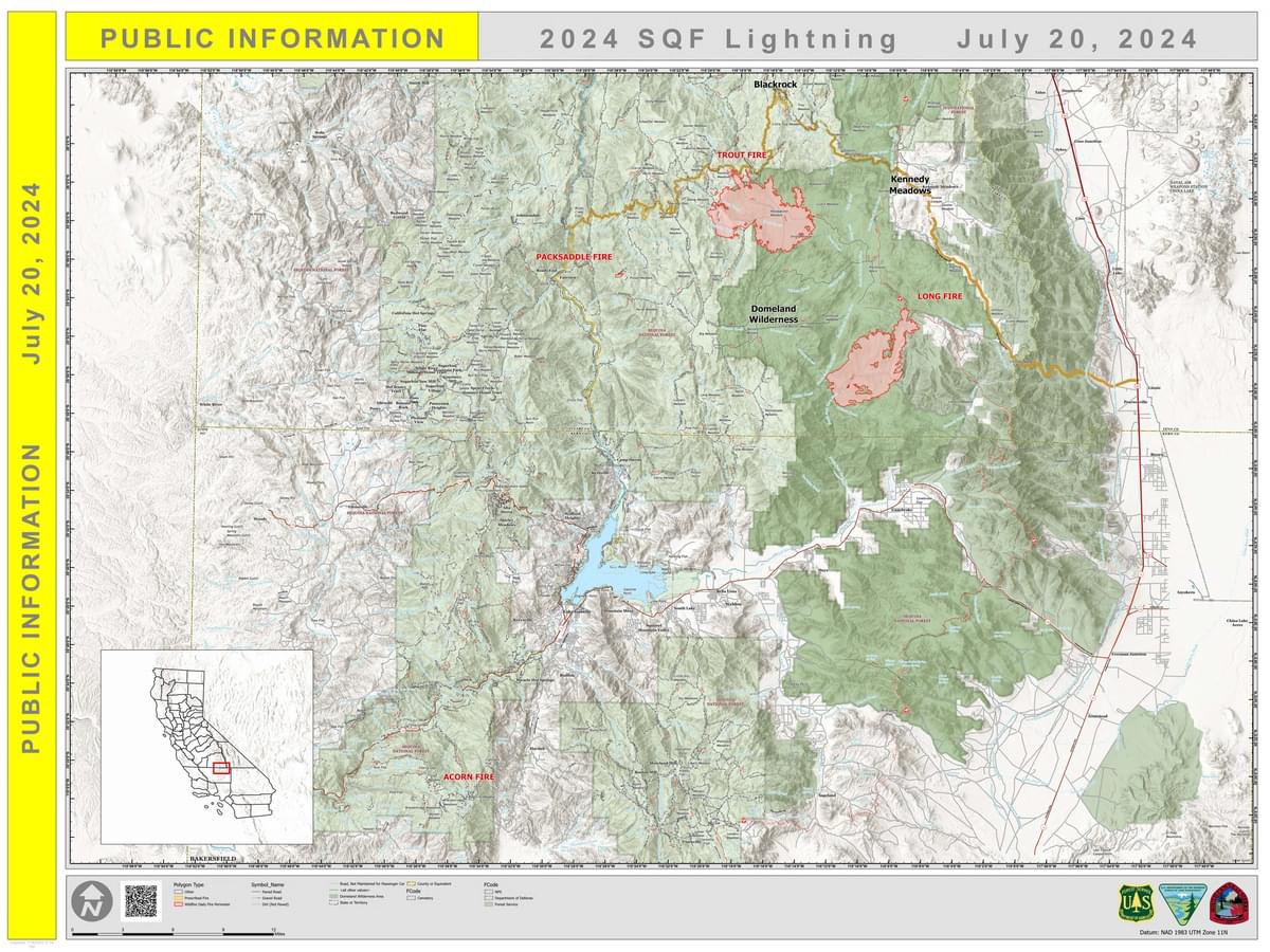
Acorn Fire: 5 acres - 95% containment
Packsaddle Fire: 47 acres - 95% containment
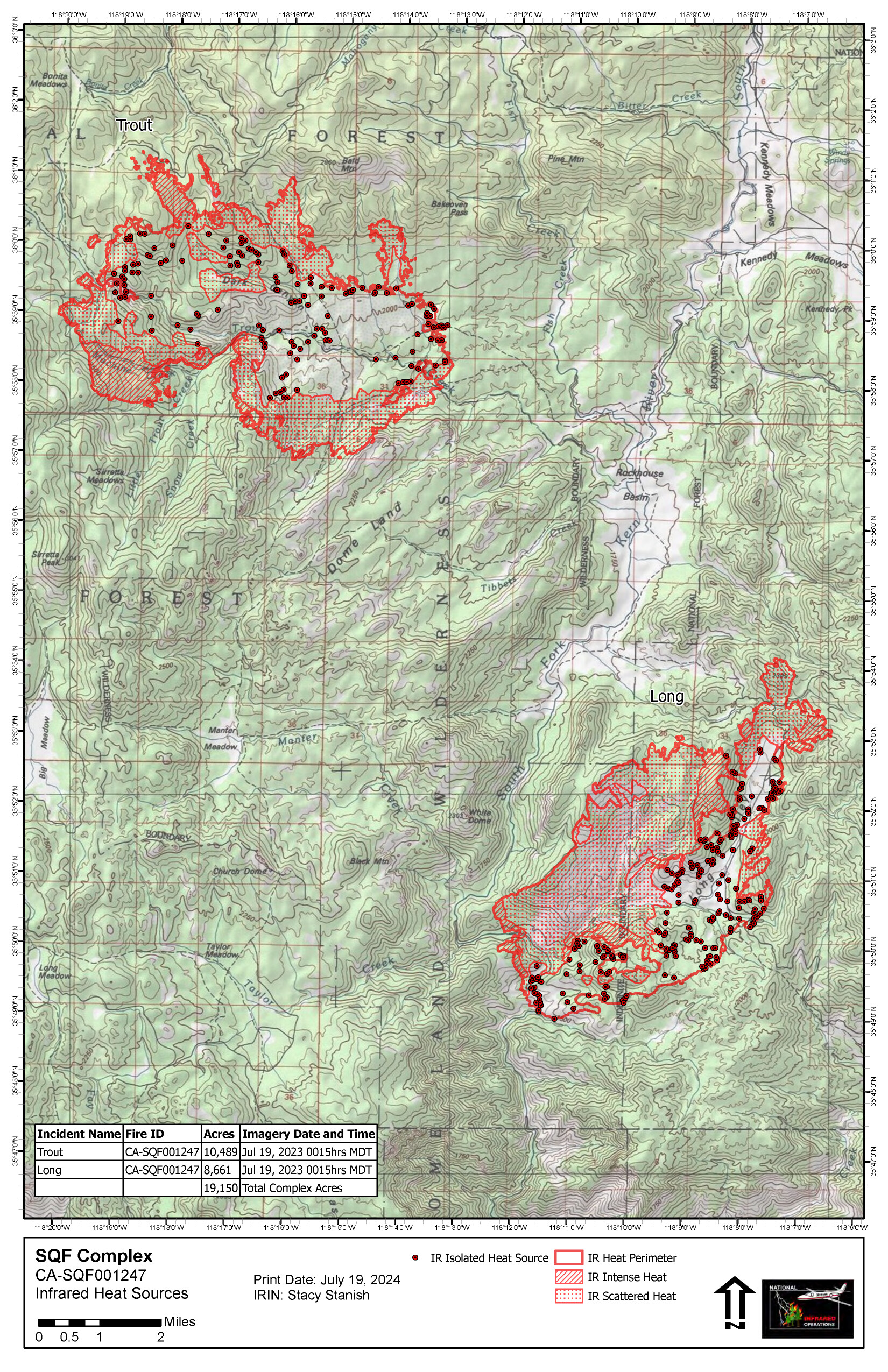
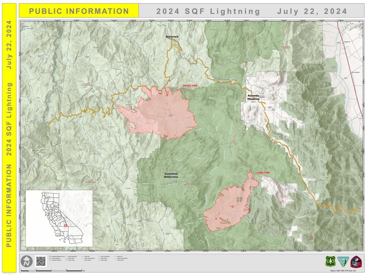
Long Fire: 8,856 acres - 0% containment
Trout Fire: 12,855 acres - 0% containment
Total Personnel: 711

Current Situation:
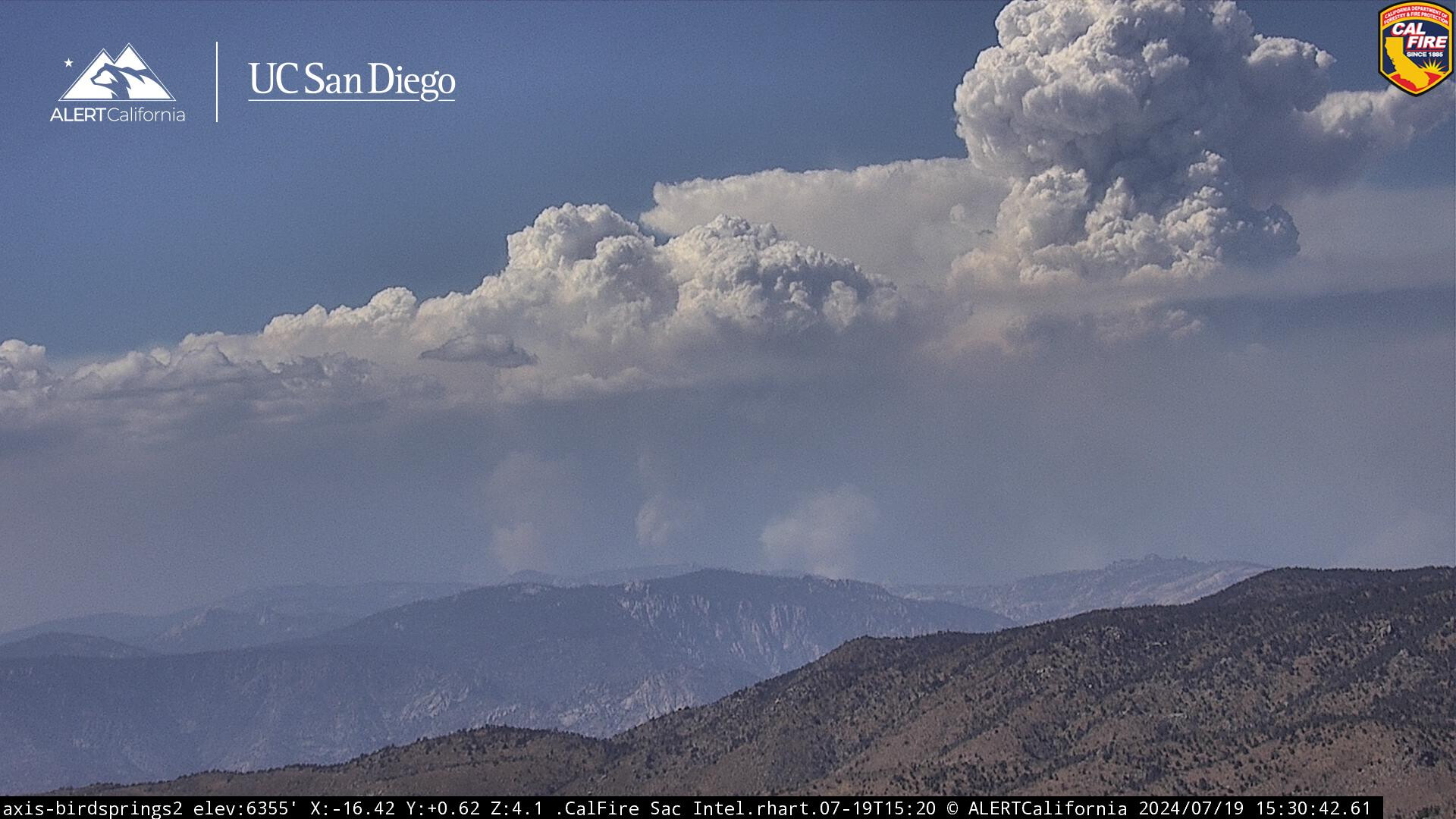
In all areas of both fires, fire managers are strategically directing specific actions and deploying equipment to meet the exact needs of each location. Last night, unmanned aerial systems were used to begin strategically burning portions of the Trout Fire’s northern perimeter to reduce fire intensity as it approaches Sherman Pass Road. Vegetation clearance is being established around structures near each fire, and a mobile retardant base has been established to allow helicopter retardant drops with faster turnaround times. This tailored approach ensures that resources are used effectively and that tactics can be adapted to the dynamic conditions of the fires.

Trout Fire:
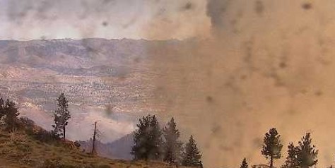
The Trout Fire experienced increased fire activity in the Machine Creek area Friday afternoon, which produced a large smoke column. However, other areas of the fire weren’t as windy, which allowed firefighters to work directly along the fire’s edge, resulting in minimal growth toward Kennedy Meadows. Today, firefighters continue to clear vegetation along Sherman Pass Rd. as the fire approaches. If necessary, strategic burns off Sherman Pass Rd. may be conducted to create a larger buffer ahead of the fire. Crews will also continue building control lines along the southern perimeter and Machine Creek area.

Long Fire:
The Long Fire showed diminished activity throughout most of Friday. This reduction in fire behavior enabled crews to make substantial progress in constructing control lines along the southern area of the fire. Today, firefighters will continue the direct line construction on the southern perimeter near the South Fork of the Kern River and Palome Creek. Along the northern edge retardant line has knocked much of the heat out of the fire ahead of crews building control line. These control lines are crucial in our efforts to contain the fire and protect surrounding communities and natural resources

Acorn Fire and Packsaddle Fire:
The Acorn Fire and Packsaddle Fire remain in a patrol status. Crews will monitor the fire perimeter ensuring there is no threat of flare-up or escape.

Weather & Air Quality:
A persistent weather pattern is forecasted for the next several days. No rainfall is expected. Temperatures will remain elevated above normal and relative humidity will near critically low levels. A daily smoke outlook is produced for the areas and communities affected by the 2024 SQF Lightning fires (tinyurl.com/452x2uzr).

Forest Closures & Restrictions:
Sequoia National Forest lands, roads, trails, and recreation sites around the Trout, Long, and Packsaddle Fires are temporarily closed under Forest Order No. 0513-24-12. Fire restrictions are also in effect under Forest Order No. 0513-24-10. Both orders, maps, and accompanying appendices can be found on the Forest’s “Forest Orders” web page: tinyurl.com/2en2d36k.

Evacuations:
Tulare County evacuation warnings have been issued for zones TLC-E274-B and TLC-E261-B, the area north of Canebrake Road, south of Sacatar Trail, west of Inyo County line, east of the South Fork and Kern Rivers.

#2024SQFLightning #SequoiaNF #KernCounty #TulareCounty

6 Likes

Old faithful handi-rest chemi standing watch. I’ll cry if that thing burns. Made in fresno back in the 209 days.

Screenshot_20240720_155051_Chrome~2

They have line running across bald mountain.
Screenshot_20240720_154939_Chrome~2

9 Likes

Long AA requesting
4 LATs
2 VLATs
MAFFs T2 & T6 will continue load and return.
Building some major mud line, if they get filled

Update @ 16:40 only 1 VLAT available has been diverted to new start NorthOps.
Request 2 Additional LATs for total of 6 LATs.

6 Likes

All 4 MAFFS(2,4,6,8), T-01, T-03, T-163.

They are hitting it hard while the can.

3 Likes

Copter 116 ( I believe a black hawk) and 77RA ( a chinook) lifted off Mariposa enroute Shafter.
Sounds like Shafter is the heliport for the Lighting Complex fires. One said Trout and the other said lighting complex. Both in route Shafter. Seems a bit south.

I saw these copters on base in Mariposa Saturday.

5 Likes

Shafter doesn’t make a lot of sense to me. Both Kernville airport and Inyokern airport are closer. But I’m sure there’s some sort of logical reasoning behind it.

1 Like

There are 13 helicopters they are utilizing for logistical support and water drops. Yesterday they were shuffling personnel from Kernville airport via helicopter. By road the only path to the area that is not affected by fire is the long way through Nine Mile Canyon.

4 Likes

Did they hold the Sherman Pass Road, looks like it?

1 Like

The Heat shows across Sherman Pass in the Caltopo, don’t know if its false or established fire:

https://caltopo.com/map.html#ll=35.97801,-118.32252&z=13&b=t&o=f16a%2Cr&n=1,0.25&a=mba%2Cfire%2Cmodis_mp

The cams from Bald Sequoia don’t show much activity. Flight radar showed 3-4 copters working the fire.

4 Likes

It is where “heavy” helibase is set up. I agree it it’s a long haul for aircraft. Logistically it is much easier to support aircraft and crews down in the flats. Have to support hotel rooms, parts and fuel. Not sure the reasons, SQF may have a land use agreement prearranged.

7 Likes

Video update from ICP at everyone’s favorite vacation area, Camp 9

https://fb.watch/ttk_BTdCjh/?mibextid=0VwfS7&fs=e&s=TIeQ9V

3 Likes

2024 SQF Lightning: Daily Incident Update (07-22-2024)

Long Fire: 8,908 acres - 0% containment
Trout Fire: 15,702 acres - 1% containment
Total Personnel: 900

Current Situation:
For over a week, firefighters on the Trout Fire and Long Fire have been using a variety of fire suppression techniques to lessen fire intensity, build control lines, and achieve complete containment. To accomplish this, crews are constructing control lines with hand tools and heavy equipment, extinguishing burning vegetation that could spread fire beyond the current perimeter; and sometimes conducting low-intensity firing operations to halt the main fire’s spread and intensity. Each tactic is strategically implemented to meet the unique challenges of different topography and vegetation. As a result of dedicated efforts, control lines on each fire are now being strengthened and are a step closer to being reclassified as containment line.

Trout Fire:
On the Trout Fire, firefighters spent Sunday night conducting strategic burns from Sherman Pass R. along Boone Meadow Rd. and 21 Rd. This was supported by a UAS (unmanned aerial system). During favorable nighttime weather conditions, the area between the fire’s perimeter and roadway were burned with deliberation and low intensity. Today, firefighters will continue to work off Sherman Pass Rd. to connect sections of control line that are approximately a half mile apart. Hotshots will be added to the east side of the fire to build handline while other crews look for natural barriers and favorable locations to build control line from Deadwood Meadow and Sirretta Pass to the fire’s edge.

Long Fire:
Fire behavior continues to diminish on the Long Fire as more and more sections of control line are completed. Several days of work are having an effect on keeping the fire from growing and acreage is holding at 8,908. Today, along the southern perimeter, where control line has already been established, crews will strengthen the line and extinguish smoldering vegetation. Between the head of the fire in the northeast and South Fork Kern River at the southwest perimeter, multiple teams of hotshot crews will work toward one another. Working through rocky terrain they will continue line construction and receive aerial support from helicopters dropping water and retardant.

Weather & Air Quality:
Showers and thunderstorms are forecasted for today. The most probable areas to see rainfall will be around the Trout Fire. All are watching the sky due to the increased potential for lightning strikes and outflow winds that could quickly create intense fire behavior. A daily smoke outlook is produced for the areas and communities affected by the 2024 SQF Lightning fires (tinyurl.com/452x2uzr).

Closures & Restrictions:
Sequoia National Forest lands, roads, trails, and recreation sites around the Trout, Long, and Packsaddle Fires are temporarily closed under Forest Order No. 0513-24-12. Fire restrictions are also in effect under Forest Order No. 0513-24-10. Both orders, maps, and accompanying appendices can be found on the Forest’s “Forest Orders” web page: tinyurl.com/2en2d36k. The Bureau of Land Management’s Bakersfield Field Office has temporarily closed Long Valley Campground, Chimney Creek Campground, and portions of the Pacific Crest Trail. View the emergency closure order here: tinyurl.com/4mprcb9b

Evacuations:
Tulare County evacuation warnings are in effect for zones TLC-E274-B and TLC-E261-B, the area north of Canebrake Road, south of Sacatar Trail, west of Inyo County line, east of the South Fork and Kern Rivers.

Current Fire Info - https://tinyurl.com/5n8v4jcv
#2024SQFLightning #SequoiaNF #TulareCounty #KernCounty

6 Likes

She sure looks angry today

4 Likes

8 Likes

It actually rained up there.

5 Likes