CA-SRF-Early August Lightning??

Large cell went through Willow Creek around 2am last night. Numerous starts on the east side of SRF along the south fork Trinity above and below Hwy299.

Bremer just east of Willow Creek
Boatman - Waterman Ridge east of Willow Creek
Campbell - above Salyer
Friday - west side of river from Salyear
Charlie - Hogback Ridge

HUU also has a couple starts right outside the SRF on the Kinsey Ridge area. SRA7 on Grouse Mtn and Prairie.

Jumpers on the SRF fires near WIllow Creek. AA120, C902 working SRA7/Prairie. T96 and Grass Valley T88/89 getting some coastal weather working out of Rohnerville on all these starts.

7 Likes

Storm rolled through in the middle of the night, Kym Kemp reporting at least 5 confirmed fires as of 0718

4 Likes

Friday fire is in the 2021 Knob scar, and 2003 Friday scar. All the other starts appear to not have fire history for a good distance.

5 Likes

Looks like 17 jumpers on the Bremer and another 7 jumpers but not sure which fire.

4 Likes

Type 2 IMT ordered (Long).

4 Likes

Which # Team is that?

2 Likes

Team 11 is going.
CAIIMT 11- 2022 SRF Lightning Complex. Tentative in brief 8/7 at 1000, Willow Creek, CA

9 Likes

Barry Ridge has decent 1 hour Timelapse of increased activity, looks like maybe 3 of these merging or at least in very close proximity. Hard to tell from the distance ALERT Wildfire

6 Likes

https://www.alertwildfire.org/region/northcoast/?camera=Axis-DeerHorn1

A little closer view…

6 Likes

Approximately 600 acres as of last night, reporting 12 fires in the complex with extreme fire behavior reported.

3 Likes

Extended freqs for the “SRF Bremer” not sure if they’ve burnt together, treating it as one name, a complex or what.

Air Tactics FM 166.900
A/G’s 164.8625 and 172.550 (unknown which is cmd or tac)
Rotor Vics 121.025 (TFR), 124.575

Also ordered up for “CNR August Support” unknown locations
Air Tactics FM 165.000, 165.8125
Victors 134.325, 123.875

2 Likes

This was yes mornin and they haven’t posted anything new yet. Today.

Six Rivers Lightning Complex UPDATE 8/6/2022 11:50am

EVACUATION ORDERS ARE UNDERWAY If you are located in a evacuation order area leave NOW.

Click the links below for up to date Evacuation Information:

Humboldt: Humboldt County Office of Emergency Services
Trinity: Trinity County Office of Emergency Services

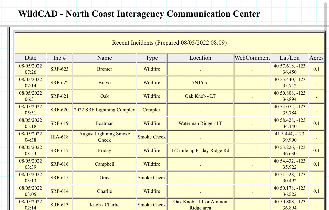
11 confirmed fires. A lot of resources really appreciate the support from our neighbors and North Ops. We are light on management, for the amount of resources we have. Fogler was able to send two operations to help. Additionally, CalFire has provided several Divisions, a Strike Team of engines and a few dozers to help provide support and leadership to help fill the gap until the Incident Management Team arrives on Sunday. Really appreciate our local Unit Chief (Kurt McCray) and the CalFire Regional office for augmenting some of our key needs.

We are making good progress on a few of the fires, but there are several that are challenging to address. We are working to keep them as small as possible and still working on keeping them out out of the larger community centers and from growing together to the extent that is safe and reasonably possible.

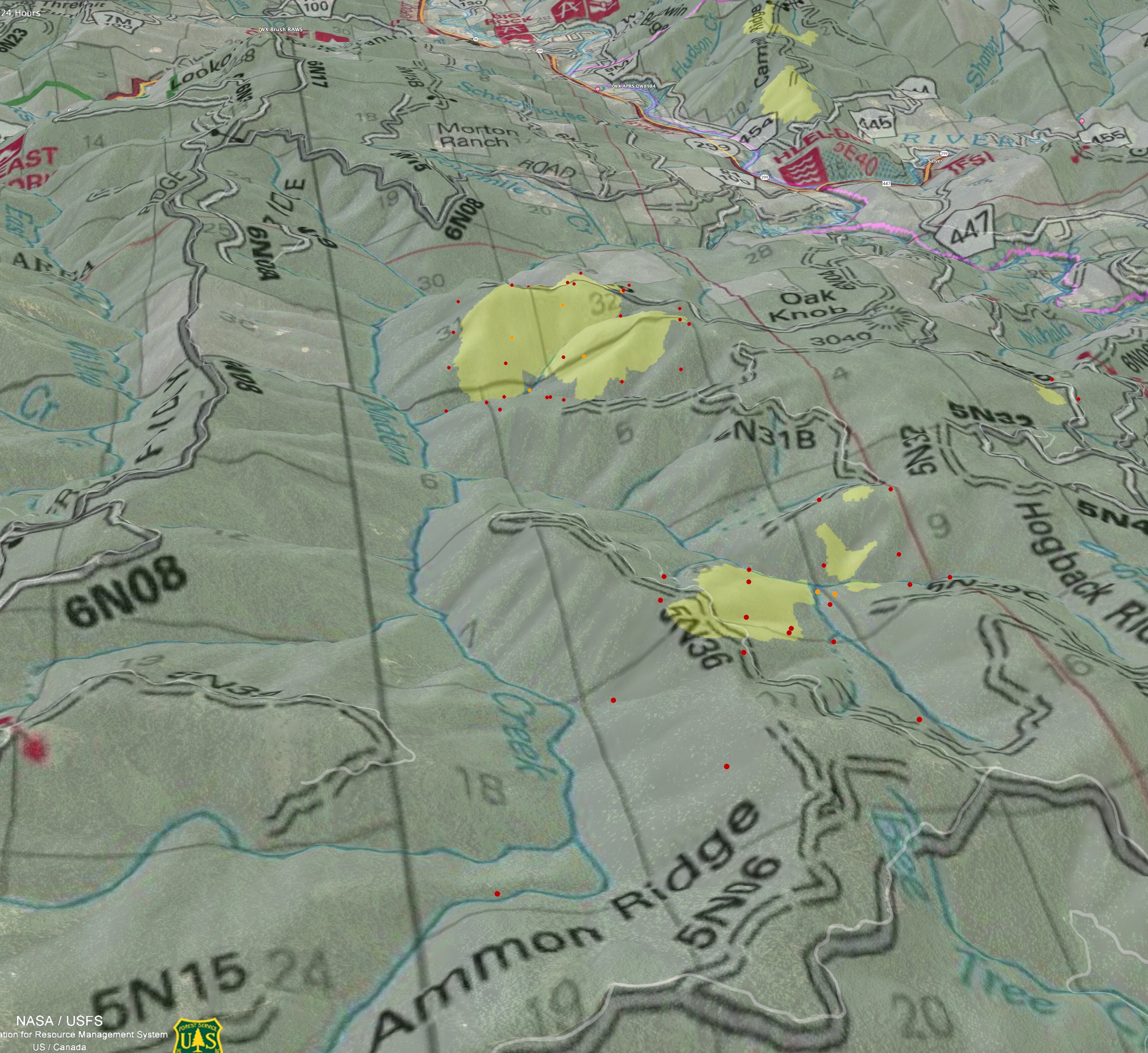
WATERMAN: Approx. 75 acres. Fire is located northeast of Willow Creek on Waterman Ridge Road 7N02 Forest Route 4.

CEDAR: Approx 80 acres. Hose lay around fire. Multiple resources on-scene, engines, watertender, and hotshot crew. Additional resources in-route. Fire is located near Waterman Fire.

BREMER: 15 acres. Four engines and one hotshot crew. Fire is located northeast of Willow Creek on ridgetop above the Bigfoot Subdivision.

CAMPBELL: Approx. 100+ acres. Fire is seeing a flare up and larger column. New evacuation orders for Salyer Heighs, Salyer Loop Road, Campbell Creek Road. Fire is located south of Willow Creek on the west side of Campbell Ridge above Campbell Ridge Road. Mad River Hotshots on scene. (Bravo and Campbell fires grew together over night. Now one fire.)

FRIDAY: Fire is located south of Willow Creek ½ mile up Friday Ridge Rd from Hwy 299.

OAK: 200 acres. Fire is located south of Willow Creek. Near FS Road 5N31 and 6N20.

CHARLIE: Contained. Hose lay and hand line around fire. Located south of Willow Creek near the Oak Fire and along FS Road 6N20.

PRAIRIE: Contained. Cal Fire jurisdiction. Located east of Maple Creek, near Rooster Rock and Snow Camp Mountain. CalFire has stopped the forward progress of the Prairie Fire.

#sixriverslightningcomplex

5 Likes

https://www.alertwildfire.org/region/northcoast/?camera=Axis-BaldJesse#

Starting to increase in activity.

4 Likes

Crossing it with a couple of other cameras, that looks like the Oak Fire. Looking at topo maps of the area, it looks like it has a lot of room to run.

4 Likes

Intel is a little slow to gather on this one. I geo-referenced a piece of the SRF map into Google Earth, mixed in some FIRIS, some VIIRS and MODIS 24hr centroids, found 4 closest weather stations, pink county line between Humboldt and Trinity. Might help anyone local who does have scanner access to reference forest roads etc. Especially on that Oak.

Get an idea of the terrain looking north up the Madden Creek canyon below Oak fire. Slight dogleg at the bottom at Ammon Ridge. MODIS hits goes down Ammon Ridge, not sure if smoke column or fire.

Weather Sat 430pm
WX Brush Mtn RAWS 78F 47RH WSW 4G18 (between Oak and Hwy299)
WX APRS DW8984 87F 50RH WNW 5G12 (in Willow Creek directly below Campbell)
WX PGE Humboldt Manzanita Ranch 86F 36RH NNW 8G16 (on the 230kv line, 9mi SE of Oak fire, shows influence up the South Fork Trinity canyon)
WX PGE 4N06 74F 56RH NW 4G12 (8mi south of Oak, behind Grouse Mtn, on the 230kv line and forest road 4N06)

1800 edit:
My Oak Fire might be the Friday fire, and Oak is the unlabeled to the south. I doubt it, but SRF keeps putting out conflicting location info on Oak and Friday. It’s an intel mess out there. Anyone on the forest or team care to help?

2200 edit:
Oak is Oak, and the unknown fire is now called Ammon fire. It was forgotten/missed in the paperwork/hidden in the smoke :man_shrugging:.

11 Likes
4 Likes

As of 1900 8/6 (no update yet 8/7): 1101 acres, timber and brush, 0% contained. Extreme fire behavior with group torching and running. Structures are threatened with Evacuation Orders and Warnings in effect. Road, area and trail closures are in effect. Type 2 CA team 11 (Fogle) is assigned, tentative in-brief planned for 8/7 . (per ONCC).

per news release: Evacuation zones can be found at community.zonehaven.com. An evacuation center has been established at Trinity Valley Elementary School, located at 730 Highway 96, Willow Creek. For more information and up-to-date evacuation information go to humboldtsheriff.org/emergency, or Humboldt County Office of Emergency Services or Trinity County Office of Emergency Services.

5 Likes

Inciweb has it up, as of this morning.

Locally, kymkemp.com has info with maps and photos. Her site is also linking to loal gov’t resources for both Humboldt County and Trinity County.

5 Likes

Why is there so little information on these fires?

2 Likes

Assuming you are asking why limited posts and Intel/photos/ play by play?

SRF, Although the SRF is completely accessible by normal routes and modes of travel, it truly is like an island. Island with limited connectivity as we would call in the modern world. Areas west of Weaverville/ Hayfork (hwy 3) and east of Berry Summit on the 299 corridor have limited cell cervice because of God forsaken terrain and lack of population.

To the north on the 96 corridor, more of the same with some com networks provided by grants through the local tribe(s).

To the south on the 36 corridor, more wild rivers And lack of population.
Intel just doesn’t come out of here. As once you go on a tour there,your there, and well… There’s a reason it was/is called the emerald triangle! And where many of the reported sightings and videos of Mr. Bigfoot originate. :grin:

22 Likes