
Looks like quarry will be managed
3 Likes
Crew reported that the Quarry had grown by 1/3 an acre.
Crews are also staffing the River Fire.
UPDATE @20:50 Crews have pulled out from the Quarry Fire mapped at 4.8 total acres.
Heading to quarters.
Long day…
5 Likes
Multiple Lightning Caused Fires Being Managed as the Quarry Fire
Benjamin Cossel, Public Affairs Officer, Stanislaus National Forest
W: 209.288.6261 | C: 209.916.5919 | Benjamin.cossel@usda.gov
Inciweb Link: Castf 2023Stfquarry Fire Information | InciWeb
SONORA, California Sept 15, 2023 – Following a tumultuous series of weekend storms resulting in more than 38 ignitions on the Forest, fire personnel with the Stanislaus National Forest are currently managing the Quarry Fire to achieve multiple resource objectives. The Quarry Fire is located off Forest Road 3N01, east of Bourland Creek and approximately four miles east of the Emigrant Wilderness Border.
Of the other fires across the forest, three (Pilot, Hamilton, and Bar) are out, 14 fires are listed as contained, 15 in control status, eight in patrol status and two (Dome and Sheering) on the Summit/Mi-Wok district are currently staffed.
The lightning ignitions were originally detected on September 9, and district fire managers immediately began work to ensure these naturally ignited fires stayed within pre-determined boundaries. The Stanislaus National Forest’s Wildland Fire Module Crew 2 and four smoke jumpers are currently assigned to the fires.
“Our main objective is to manage the fire for resource benefit while keeping it away from sensitive historical and archeological sites and any other potential items at risk,” said Summit/Mi-Wok Fire Management Officer, Shaun Craig.
“Allowing natural fire to spread in areas where it can be safely and effectively managed helps restore natural fire return intervals, increasing forest resiliency and aiding in reducing catastrophic wildfire risk to our communities,” said Stanislaus National Forest Supervisor, Jason Kuiken.
Kuiken noted that every fire – prescribed or wildfire – has a containment strategy developed using a full spectrum of management actions that consider fire and fuel conditions, predicted short- and long-term weather conditions, values at risk, resource availability, land management plans and designations, smoke impacts, and the potential for successful consumption of fuel loads.
“Every management strategy identifies places suppression resources need to prioritize activities based on values at risk. However, containment strategies may include identification of natural barriers or locations where fire could be ecologically beneficial,” said Kuiken.
Smoke may be visible from Highway 108, Rim of the World Vista Point and the potential for temporary road closures may be in effect along Forest Service Road 3N01. Individuals traveling in the area are encouraged to use extreme caution and drive slower than normal as fire equipment moves in and out of the area.
7 Likes
Quarry is 9 acres now per wildcad
5 Likes
Update, Quarry Fire, September 19, 2023
The Quarry Fire is located on the Miwok Ranger District, Stanislaus National Forest, off Forest Road 3N01, east of Bourland Creek and approximately four miles west of the Emigrant Wilderness Border.
Today crews brought fire across the ridgetop near Forest Road 3N16 to allow it to slowly move down towards Forest Road 3N01.
Crews successfully burned 20 acres bringing the total acreage of the Quarry fire to 29 acres.
The optimal conditions today allowed burn out operations to consume accumulated fuels resulting in very little smoke impacts.
Allowing natural fire to spread where it is effectively managed will increase forest resiliency.
There may be residual smoke in the morning along the Highway 108 corridor.
5 Likes
https://ops.alertcalifornia.org/cam-console/2178
If we get any kind of N/NE wind this could get a little interesting.
6 Likes
here’s to hoping that doesn’t happen
4 Likes
They put a lot of fire on the ground.
4 Likes
A quick measurement on the camera fire on the ground is a good mile long. Just based on near IR signatures.
5 Likes
I was just on the Ops.alertcalifornia and no cameras for Mt. Lewis and Strawberry. Icons gone.
Info?
Thanks Be Safe
3 Likes
Both cameras went dark at 0357
6 Likes
136 acres for the quarry this morning a division chief and a additional hand crew has been assigned sounds like a type 3 team will mobolize
7 Likes
They’re back online.
6 Likes
4 Likes
Quarry Fire Update
Thursday, September 21, 2023
Stanislaus National Forest
Incident Management Team (Type-3)
PIO Contacts: Phyllis Ashmead, phyllis.ashmead@gmail.com and Eugenie Moore, eugenie.moore@usda.gov
Fire Statistics:
Location: The Quarry Fire is located on the Miwok Ranger District, Stanislaus National Forest, off Forest Road 3N01, east of Bourland Creek and approximately four miles west of the Emigrant Wilderness Border.
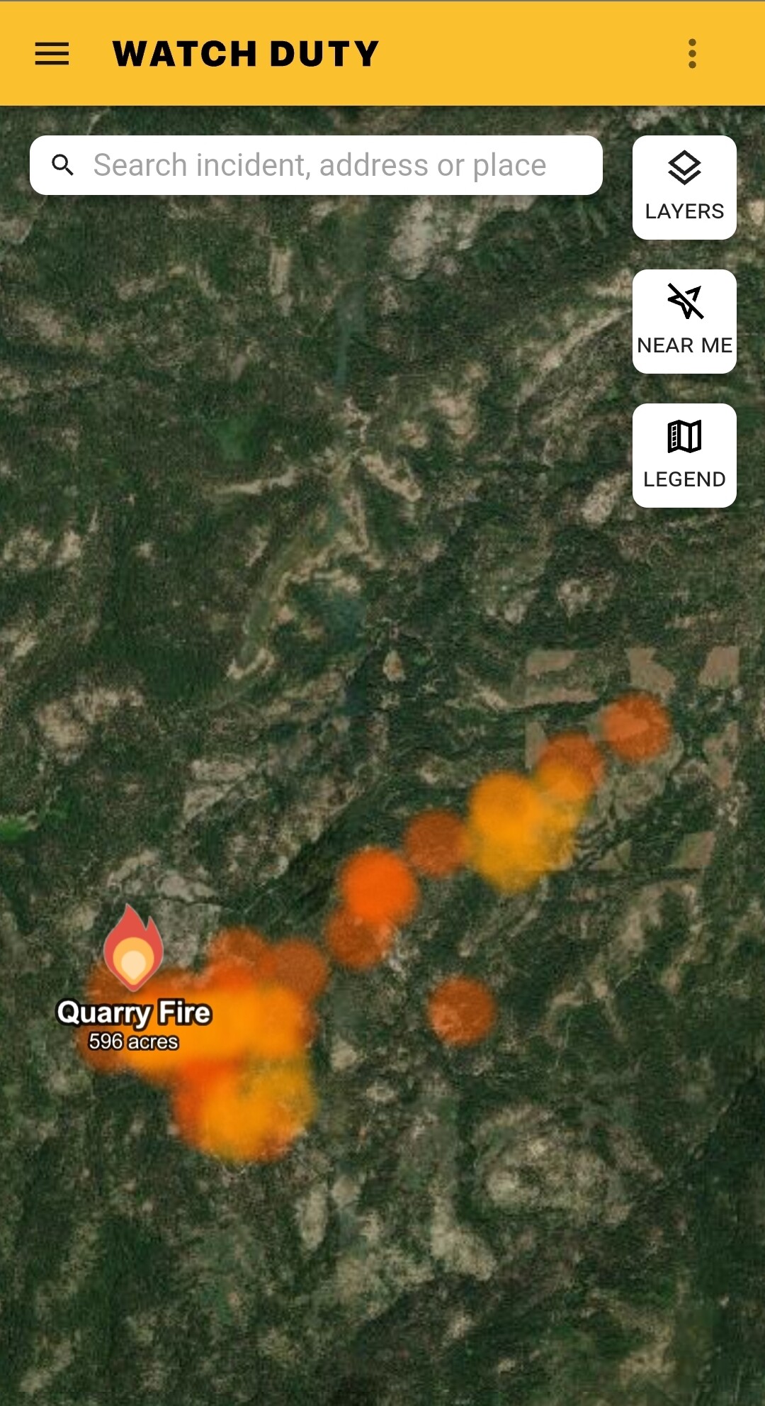
Acres burned to date: 596 acres.
Cause: Lightning
Total Personnel: 74 Injuries: 0
Background: The Quarry fire was one of many fires ignited by lightning strikes across the forest on September 9, 2023. District fire managers immediately worked to ensure these naturally ignited fires stayed within predetermined boundaries. Fire personnel with the Stanislaus National Forest are currently managing the Quarry Fire to achieve multiple resource objectives.
These objectives include benefits such as reducing concentrations of dead ground fuels, re-establishing multigenerational timber stands, improving wildlife habitat, promoting vegetation diversity, and re-introducing fire into fire adapted ecosystems.
Today’s Activities:
Today, favorable weather conditions allowed crews to expand the fire area, burning east along Forest Road 3N01, southwest from the ridge near Forest Road 3N45Y and east along Forest Road 3N21.
By the afternoon the fire started consuming well, resulting in a mosaic effect of burned and unburned vegetation which will increase habitat diversity on the landscape.
Crews also scouted and prepped other areas to protect natural and cultural resources in future burn areas.
With hunting season in full swing, the public is asked to avoid active fire areas. Watch for signs that indicate the roads in the area may be temporarily closed.
Crew 2, Crew 3, Engine 332 will be onsite all night.
6 Likes
looking like a real good burn in my uneducated opinion. temps are in the low 70s the next few days too. I’ve had condensation on my car the past few mornings. Just my personal observations.
5 Likes
Quarry 900 acres
5 Likes
Quarry is now 1532 acres.
4 Likes
Is it out? Over 4.6 inches of rain on Cooksie Mountain.
3 Likes
No Ariel ignitions planned for tomorrow
3 Likes