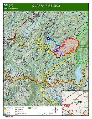
Does anyone have info on how big the planning area is for the Quarry?
Latest fire spread probs shows little or no growth expected the next 7 days. 1000 fires shows a final avg size of 5286 acres. The incoming precip and cold wx along with pre-existing line construction would seem to back that up. Pretty sure all the aerial ignition work was completed ahead of tonight/tomorrows front.
NIFC reported 5557 acres last night
@Stanislaus_NF FB page says this this morning
Quarry Fire Update
September 30, 2020
The Quarry Fire is located on the Miwok Ranger District, Stanislaus National Forest, off Forest Road 3N01, east of Bourland Creek and approximately four miles west of the Emigrant Wilderness Border.
Acres Burned Today: 819
Acres Burned to Date: 5,517
Total Personnel: 114
Cause: Lightning
Background: The Quarry fire was one of many fires ignited by lightning strikes across the forest on September 9, 2023. District fire managers immediately worked to ensure these naturally ignited fires stayed within pre-determined boundaries. Fire personnel with the Stanislaus National Forest are currently managing the Quarry Fire to achieve multiple resource objectives.
These objectives include benefits such as reducing concentrations of dead ground fuels, re-establishing multigenerational timber stands, improving wildlife habitat, promoting vegetation diversity, and re-introducing fire into fire adapted ecosystems.
Current Activities:
Crews completed firing on the eastern flank bringing fire down to Reynolds Creek. Favorable burning conditions produced good consumption of heavy dead and down woody material. UAS (Unmanned Aerial System) conducted reconnaissance for future burning opportunities.
On the western flank of the fire, crews on the ground and crews flying the UAS brought fire down to the 3N27C road, filling in the unburned areas.
Fire professionals are managing fire behavior and intensity to provide for multiple resource benefits including reducing concentrations of all fuels, re-establishing multigenerational timber stands, improving wildlife habitat, promoting plant diversity, and re-introducing fire into fire adapted ecosystems.
Closures:
Soft closures are in effect to provide for the safety of the public utilizing public lands as well as fire personnel working in the area. The soft closures are an encouragement for the public to stay clear of the area, to find alternate routes to their locations and to provide fire personnel the widest berth possible as they go about their mission. With the public’s cooperation, we will continue to monitor the number and duration of each, recognizing that fire personnel and public safety is the focus.
As of September 30, 2023, the following soft closures are in effect:
• 3N21 where it meets 3N16
• 2N71 where it meets 3N16
• 3N21 where it meets 3N01
• 3N22 where it meets 3N01
• 3N34Y
• 3N01L
• 3N01I
• 3N01H
• 3N16
• 3N01 between Bourland Creek to Reynolds Creek
• 3N01 at 3N16
• 3N16 at 3N94
• 3N01 at 2N05X
Smoke:
Smoke impacts from the Quarry Fire, the prescribed burns of the Experimental Forest, Dry Meadows and Beardsley Burn units on the Summit Ranger District will cause smoke to settle in low lying areas. Check out the fire and smoke map at fire.airnow.gov for more information.
Quarry Fire Update
October 1, 2023
Acres Burned Today: 40
Cause: Lightning
Injuries: 0
Acres Burned to Date: 5,557
Total Personnel: 138
Current Activities:
There was very little growth on the fire’s perimeter today, with rain and drizzle falling most of the day. Crews worked on clearing hazard trees near roads and trails, and gathered down fuels for pile burning.
Closures:
Soft closures are in effect to provide for the safety of the public utilizing public lands as well as fire personnel working in the area. The soft closures are an encouragement for the public to stay clear of the area, to find alternate routes to their locations and to provide fire personnel the widest berth possible as they go about their mission.
With the public’s cooperation, we will continue to monitor the number and duration of each, recognizing that fire personnel and public safety is the focus.
As of September 30, 2023, the following soft closures are in effect:
3N21 where it meets 3N16 3N34Y 3N16
2N71 where it meets 3N16 3N01L 3N16 at 3N94
3N21 where it meets 3N01 3N01J
3N22 where it meets 3N01 3N01H
Smoke:
Smoke impacts from the Quarry Fire, the prescribed burns of the Experimental Forest, Dry Meadows and Beardsley Burn units on the Summit Ranger District will cause smoke to settle in low lying areas. Check out the fire and smoke map at fire.airnow.gov for more information.
Quarry Fire Update
Friday, October 6th, 2023
Stanislaus National Forest
Incident Management Team (Type-3)
PIO Contacts:
Eugenie Moore - eugenie.moore@usda.gov
steve lyon - slyon@nps.gov
Fire Statistics:
Location: The Quarry Fire is located on the Stanislaus National Forest, Mi-Wok Ranger District, off Forest Road 3N01, east of Bourland Creek and near the Emigrant Wilderness west of Cherry Creek.
Acres Burned to Date: 5,797
Cause: Lightning
Containment: 33%
Total Personnel: 101
Injuries: 0
Background: Fire professionals using Unmanned Aerial Systems (UAS, also known as drones) are managing fire behavior and intensity to provide for multiple resource benefits including reducing concentrations of all fuels, re-establishing multi-generational timber stands, improving wildlife habitat, promoting plant diversity, and re-introducing fire into fire adapted ecosystems.
These UAS flights have a light footprint to bring fire to sensitive areas with minimal impact on the wilderness.
Current Activities: No fire movement today due to recent moisture. Crews made improvements to holding lines, including using natural features such as granite outcroppings to improve effectiveness, in anticipation of further fire spread later this week when weather and fuel moisture improves.
Fire professionals are managing fire behavior and intensity to provide for multiple resource benefits including reducing concentrations of all fuels, re-establishing multigenerational timber stands, improving wildlife habitat, promoting plant diversity, and re-introducing fire into fire adapted ecosystems.
Closures: Soft closures are in effect to provide for the safety of the public utilizing public lands as well as fire personnel working in the area. The soft closures are an encouragement for the public to stay clear of the area, to find alternate routes to their locations and to provide fire personnel the widest berth possible as they go about their mission.
With the public’s cooperation, we will continue to monitor the number and duration of each, recognizing that fire personnel and public safety is the focus.
As of October 6, 2023, the following soft closures are in effect:
2N71 where it meets 3N16
3N21 where it meets 3N16
3N21 where it meets 3N01
3N22 where it meets 3N01
3N17 where it meets 3N29
3N29 to 3N29C
3N16
3N34Y
3N01H
3N01J
3N01L
Smoke: The amount of smoke in the air is carefully planned for. Burn Bosses are in close alignment with and get approvals from the Tuolumne County Pollution Control District each day to burn the maximum amount of acreage that will not negatively impact air quality to an unsafe level. Additionally, firefighters monitoring smoke are staged around the vicinity of the fire to adjust tactics to minimize smoke impacts.
If possible, minimize outdoor activity if you are sensitive to smoke. Smoke does tend to settle in low-lying areas in the evenings to the mornings, so camping and recreating in this vicinity is not advised. To check air quality, visit fire.airnow.gov.
More Information:
INCIWEB - Quarry Fire Info - Castf 2023Stfquarry Fire Information | InciWeb
Stanislaus National Forest – Official Website - Stanislaus National Forest - Home
Engine 332 assigned is back from R&R from the quarry fire and is now assigned the peak and water house fire use fires.
Quarry
Acres Burned to Date: 6,553
Cause: Lightning
Containment: 41%
Total Personnel: 64
Current Activities: Yesterday, precipitation and cooler temperatures resulted in low fire activity. Hand crews and fire engines were actively patrolling the fires edge and mopping up in areas where heat and smoke were found. There was very little fire growth.
Waterhouse is 55.6 acres
Peak is 112.5

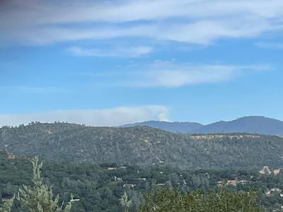
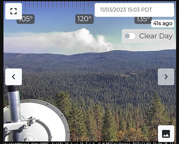
We have a steady south wind here in Sonora. Quarry fire a little active today, generating a lot of smoke.
Quarry is now officially contained per STF. In Patrol status.
no recent updates on Peak or Waterhouse.


