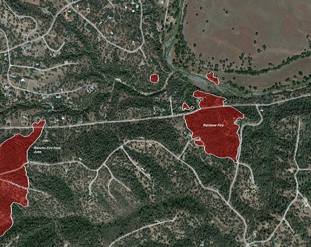
CA-TGU-Rainbow??

Rainbow Ridge Road, Rancho Tehama.

AA bumped order to total of 4 S2, 1 LAT and 2 copter.

IC 10 addl engines immediate need. Evac orders. Grass oak woodland rapid rate of spread. No size heard. On road…

100 acres, 5 addl dozers 4 addl crews

Scanner Northern Sacramento Valley Fire

3 Likes

https://www.alertwildfire.org/region/shastamodoc/?camera=Axis-Flournoy

1 Like

https://www.alertwildfire.org/region/shastamodoc/?camera=Axis-RoundMtnPaskenta

1 Like

Isn’t this basicly where the rancho fire was a few weeks back?

I believe you can see the rancho scar on the cams to the West and South of the plume.

1 Like

New Start:BTU

https://www.alertwildfire.org/region/shastamodoc/?camera=Axis-OrovilleCaStParks

Correct me, but looks like two different fires, cameras are not lining up and looks like @EPBL41 New Start is the correct BTU location. Different than Rainbow.

2 Likes

Greenbrier incident in BTU, forward progress stopped

6 Likes

Thank you.

T94 being diverted from this fire to a fire in SKU

3 Likes

Start of Rainbow is east just under a mile as the crow flies from start of Rancho…

Mapped at 30 acres by FIRIS. Those extra 70 acres from IC’s report on condition must have been smoke acres… this area is certainly tinder dry and not a place we want any fire. Insane WUI and one way in and out. Evacuees were turning west onto Rancho Tehama “away” from the fire, only to get stuck with no through roads. Tehama Sheriff dispatcher was google map sat viewing a private unmaintained dirt road that would get them to the Stagecoach Road system and out, but fire behavior dissipated enough local deputies said to just shelter in place for now at the end of the road.

7 Likes