
Not that big, just checked state draw down , should be able to meet need with state engines
4 Likes
State should be able to fill at least 23 STC in house
3 Likes
I’ve heard word of LG OES Type 3’s getting mobilized too
25 T3 strike teams ordered
1 Like
XCO3025C en route to fire at 20:00
OES WT 31 en route 21:00
3 Likes
So the map posted earlier I believe is still somewhat roughly accurate with what I’ve been hearing, just a bit longer with the northern end reaching Sec 12 near Halley Spring. That’s the head as of sundown. 7-8 miles south of Hwy 36.
When they reference Hammer Loop, that’s the road loop that goes around Rocky Point to Hammer Place. Not sure how much it’s gotten into the loop on that left flank, they’re still getting intel on that. Had some residents trapped in some homes out there needing extrication.
Tonight around midnight the 15-22mph SE winds will shift to the NNW roughly 8mph. a complete 180 basically. They are anticipating this and putting a LOT of resources in at the heel of the fire now including hoselays, crews and iron. Focusing on getting a fat line secured on both the north and south sides of South Fork Cottonwood Creek (which cuts across the bottom third of the fire), on both the east and west flanks of the main fire. With the wind shift, not much continued spread up to Hwy36 for tonight.
Tomorrow winds forecasted to move upslope about 5mph, then shift to an east wind in afternoon 4-9mph.
10 Likes
STEN XYO 4275C en route for briefing at 0700hrs
OES 4801C enroute from Sacramento
2 Likes
Grizzly Incident Support GIS module en route
1 Like
XMY ST2175C responding from Monterey County
OES 2870C en route
XAL 2001C en route
0410 NWS Discussion for the Northern Sac Valley (clipped from the point forecast). Looks like conditions may be moving in a favorable direction. The 0700 briefing will tell.
DISCUSSION… A departing upper trough over the Pacific Northwest will allow high pressure to build temporarily over the north state today ending the isolated shower and thunderstorm threat that we have seen over the last couple of days. Daytime highs today should come in similar or just a bit lower than Thursday but still a few degrees above normal for late summer. Daytime temperatures will see a bigger drop over the weekend as a Pacific weather system passes through to the north. Daytime highs Saturday and Sunday are expected to come in a few to several degrees below normal. Parts of the weekend will see a fair amount of cloud cover as this system moves through especially Saturday but, at this time, precipitation is expected to remain north of the forecast area. A fairly strong delta breeze can be expected on Saturday as the trough pushes into the Pacific Northwest coast with coastal stratus likely into the delta region and possibly into the central valley Saturday morning. Another upper trough will move into the Pacific Northwest on Monday bringing even lower daytime temperatures to the CWA. Daytime highs Monday are forecast to run anywhere from a few to as much as 10 degrees below normal. As with the previous system, precipitation is expected to remain north of the forecast area.
1 Like
4100C out of nevada county in route. BR23 BR57 BR89 E52 E5464
1 Like
Per Cal Fire Twitter:
#RedBankFire off Hammer Loop Road and Petty John Road, West of Red Bluff in Tehama County is 6,500 acres and 5% contained. Evacuation warnings and road closures in place.
Air show is starting up. Crane off of Helibase enroute. AA240 overhead requested 1 ASM and 4 Type 1 tankers to the fire.
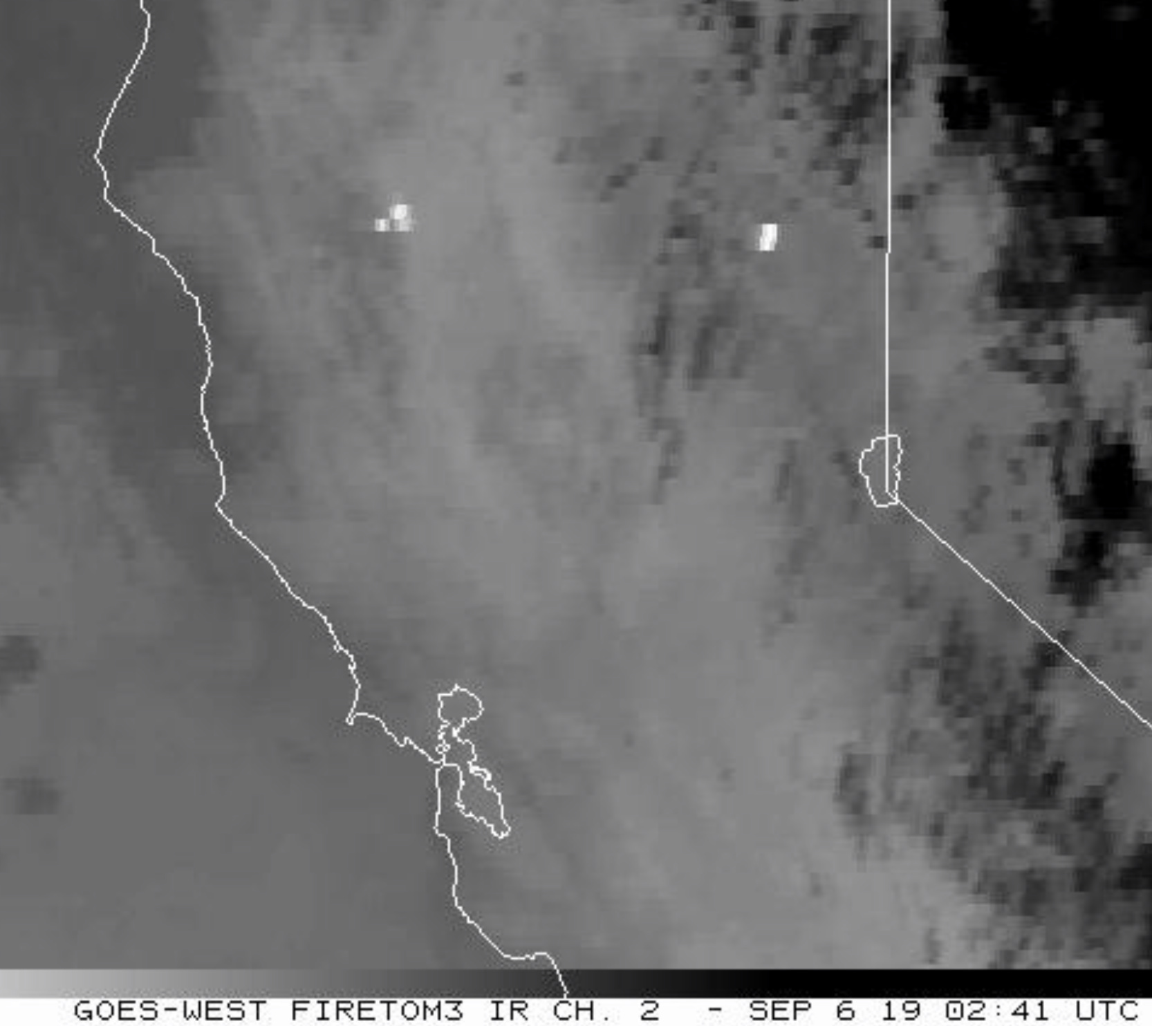
Fire is looking REAL good this morning. Winds did the shift to the north as forecast, but was also minimal to none. Lost a LOT of heat on GOES17, bringing PNF-Walker back as the hottest thing going at the moment. SHF-South (the fire on Tomhead) has more heat than this one at the moment.
scancal.org/live.html has the updated Air Ground and Air Tactics FM for the day. I’m steering it remotely, with FreeScan remote which is somewhat blind and delayed, so it’ll take a bit to make sure Air FM is working properly. It has a smattering of tacs as well but only what I have preprogrammed as TGU tacs.
Inversion is lifting and both Red Bank and SHF-South have columns starting to lift.
2 Likes
When you say the fire is looking “Good” is that meaning it’s loosing steam or growing? Some of us on here can take “Good” either way Hahahah.
6 Likes
At this point, it’s definitely good for the pocket. However in the intel context, my “good” is it’s got the wind knocked out of it currently, very little smoke coming up, and behaving well enough for Operations to kick some ass today. We’ll see what happens when the wind and temps pick up.
The SHF-South behind this is putting up quite the column now and it’s moved quite a bit up from my vantage.