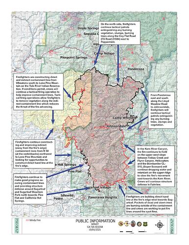
CA-TIA-Windy?? (Was SQF-Windy?)

Thanks apx8000 -

Coincidently I just looked at that 2130 update. Been watching the south end of the fire creep east towards Mineral King , a favorite area of mine so hoping the crews can contain that s/e flank.

As for the tankers, I was watching as they departed Fresno thinking they were headed to the south end of the complex, but instead they followed “leed71” once they got over the Sierra around 7k ASL.

1 Like

There are two very common paths above Isabella. One is the Isabella refueling track which is very easy to spot as it is an oval. Usually the tanker is broadcasting but hardly the a/c that’s refueling. Which is common practice in R-2508.

The other is the low level route which starts just south of the lake and basically follows the river up to Owens valley.

I do know during the French fire some pilots were still flying the low level.

MAFFS 4&6 we’re actually flying thru prior to their use this year and them being station at MCC. My buddy has pics on his Instagram with their fire paint schemes and numbering.

Just some extra trivia about the already intriguing area around this crazy fire.

5 Likes

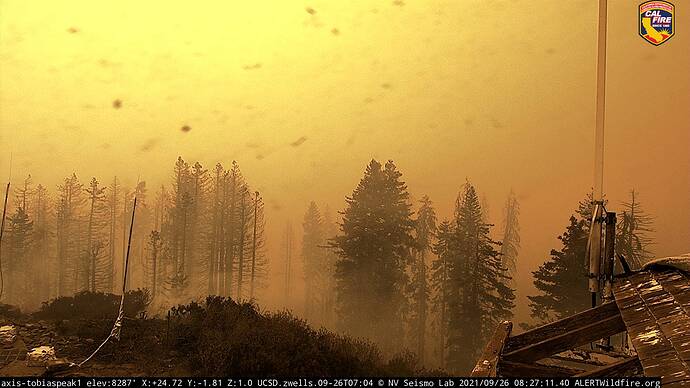
The fire has overrun Tobias peak lookout but it’s still there. Check out the 12 hr. @ALERTWildfire.
http://www.alertwildfire.org/sierra/index.html?camera=Axis-TobiasPeak1&v=fd40742

Sidenote if you don’t properly secure the fire resistant wrapping it’s just going to blow off when the fire approaches.

Screenshot_20210926-073035~2

11 Likes

The portable repeaters. Bet the coax melted. They don’t use plenum rated/fire rated coax. That wouldn’t be lowest bid. Hardware Boxes might have held up?

I can hear Cmd12 in Fresno… it works! Maybe they wrapped the antenna mast and cable? I see a drooping aluminum wrap at bottom of mast.

10 Likes

they wrapped the cables, the poles were in the ground, so no guy ropes needed. Everything still working

6 Likes

AA51 is over the incident at 20:00 asking ops about activity on the fire. Sugarloaf was the highest concern. Secondary is Hot Springs.
Did they get night ops copters or this is just IR?

Getting setup for perimeter readings and get that intel to Div. A and J.

4 Likes

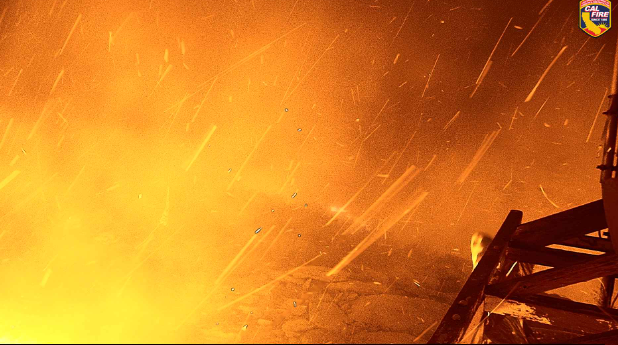
Those cams at Tobias Peak sure are showing lots of activity.

Night vision turning off due to so much light from active flames. Not good.

2 Likes

Going to be plenty of flare ups around Tobias for a while. It looks like the fire is pretty well established in the cedar burn.
http://www.alertwildfire.org/sierra/index.html?camera=Axis-ShirleyPeak2&v=fd40742

Fire front on Tobias: SQF Windy 9/26 Tobias Peak Burnover - YouTube

4 Likes

West winds have surfaced. Cameras and trees are getting pushed pretty good. Cant really see any identifiable columns building yet. Good luck to those holding the lines.

4 Likes

Intel 24 just flew the fire again. No major change in perimeter last two days. Spot fire in Bull Run Creek, which is farthest south so far.

6 Likes

Hope they can stop that spot easy. That is a snake infested mess!

6 Likes

Anyone have a QR code for this incident. I have a granddaughter & son-in-law working as Line Medics there?

2 Likes

The QR code will only open the IAP. Here is the link to the FTP server with it.

https://ftp.wildfire.gov/public/incident_specific_data/calif_s/!2021_Incidents/CA-TIA-003058_Windy/

2 Likes

Watching the briefing this morning it sounds like they are planning on going direct on most of the fire. The weather has been favorable not a lot of heat on much of the perimeter. Good news.

12 Likes

Chief discussed using Scoopers for the Kern in this morning’s Ops Briefing.

3 Likes

91,237 acres and 52% contained this morning. Still warm and dry. Forecast has the possibility of some moisture next week, but too far out to be accurate. In the interim still some areas to watch.

3 Likes

A post was merged into an existing topic: CA-KNP-Complex???

Anybody have a burn severity map of this yet?