State ID:CA
3 letter designator:SQF
Fire name:Windy
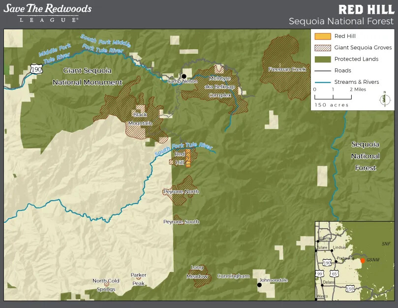
Location: Red Hill Grove of redwoods near Crawford Camp
Reported acres: 2
Rate of spread: MROS
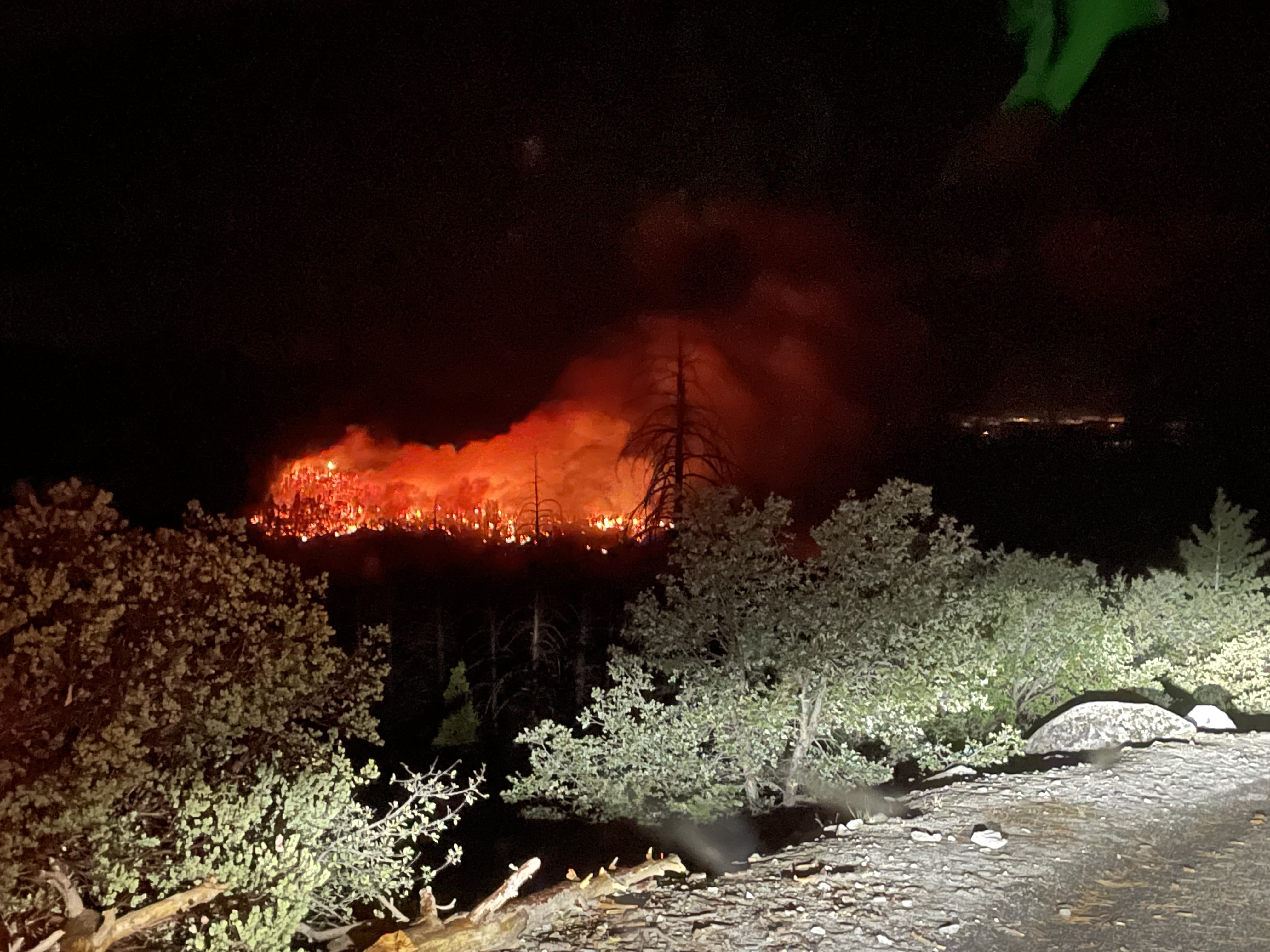
Report on Conditions: gusty winds driving fire spread, spotting
Structure threat:unknown
Resources: SQF 2 engines, 2 crews, BC
Hazards: severe thunderstorms and down strikes
Weather: severe thunderstorms
Radio channels: SQF ch.4 170.55
Scanner link: MAP : CalTopo - Backcountry Mapping Evolved
Webcam link:ALERTWildfire | Sierra-Foothills (Run a time laps to see lightning-maybe fire glow)
Agency Website:
6 Likes
Crews are pulling back due to erratic fire behavior with the thunderstorms. Will wait until storms pass.
Heat might show at day break on the caltopo so, refresh later.
Probability of more starts likely, due to little moisture.
7 Likes
Tobias peak is showing it plus a spot or separate fire.
http://www.alertwildfire.org/sierra/index.html?camera=Axis-TobiasPeak1&v=fd40740
4 Likes
BC reports 10 acres. Has crested the top of the hill is backing down hill.
Towards Windy creek ?? Might access out of Cholollo Camp ground.
This is just one fire out of what might be 5 additional.
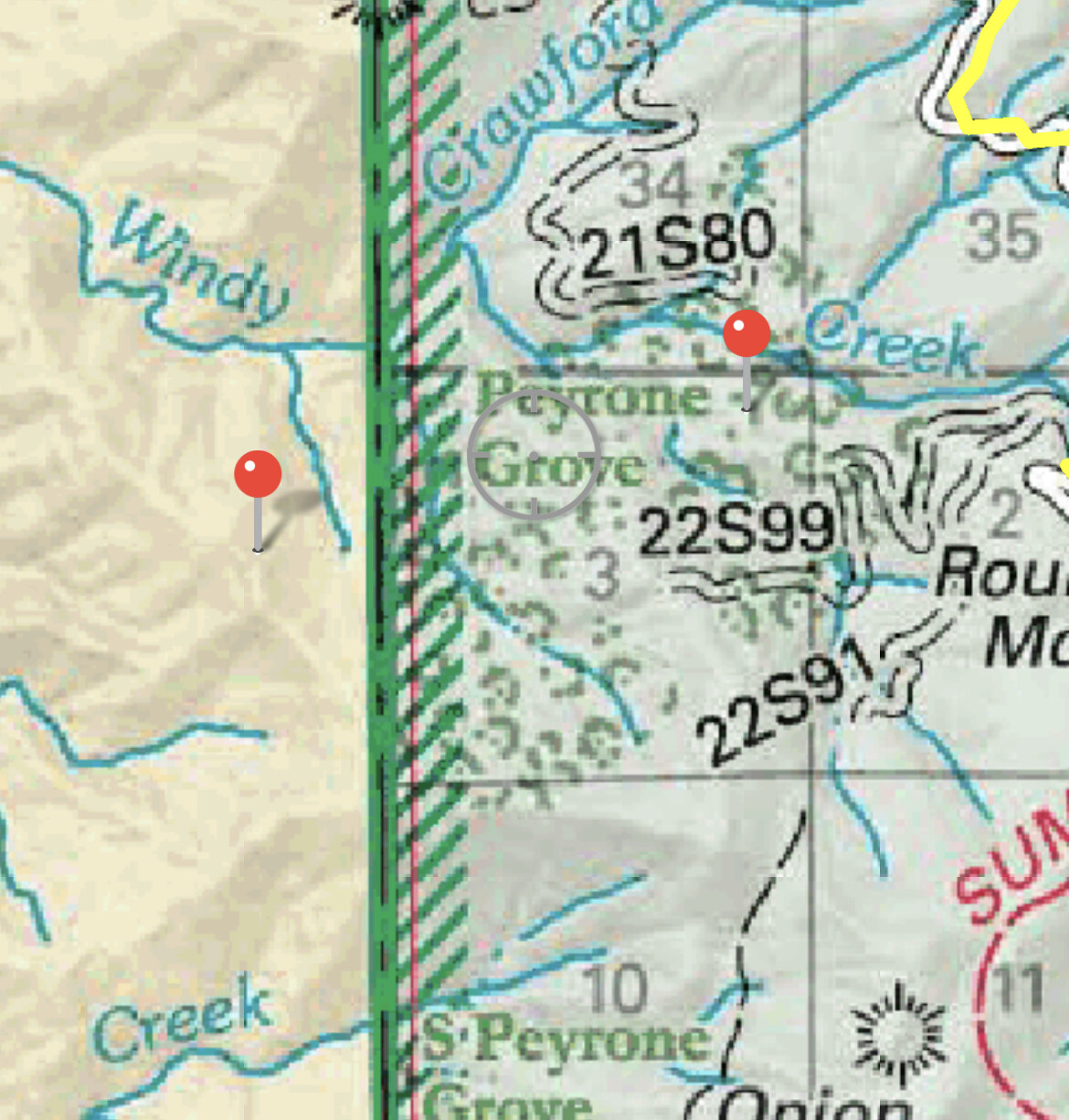
Some fires split off on ch.2 SQF, Peyrone incident.
Looking at Wildcad which just came up with the following fire names within a few minutes of each other:
Windy (on TIA, SQF line), Millwood, Peyrone, Crawford, and Methuselah… so far @ 20:50. No lat-long for any posted. You can drop a pin on caltopo for red hill, approx= 36.06 -118.62
http://www.wildcad.net/WCCCICC.htm
Complex in the works??
Orders being placed for early up aircraft and additional ground crews.
6 Likes
No fire history in this area that I am aware of, Windy Creek/Windy Gap. Back side of Slate is ripe. Huge fuel load. Redwood groves that have been preserved and no logging for a long time (since the 40’s/50’s) and fir stands with lots of standing dead and down. Access from Peppermint for the Windy Creek fire, off 190/Western Divide… Not sure about the others.
4 Likes
Heat signature already? RAMMB/CIRA SLIDER: Satellite Loop Interactive Data Explorer in Real-time with GOES-16 and Himawari-8 Satellite Imagery
Recent history: Giant sequoia forest preserved in landmark conservation deal
1 Like
Lots of traffic on Forest ch.2 169.900… access and staging Crawford Rd.
Fire is bumping Crawford Road. Maybe same as 21S94?? It’s bumping some road on the down hill run…Crawford side not accessible.
Talk of combining into Windy Complex… thought that would happen.
I am missing all the resource requests. They include 3 copters, AA and 2 tankers early up as soon as possible.
Going use BC91 to place orders through and drop “Peyrone” fire as separate and combine the two.
UPDATE EDIT 23:45
Another fire found “Caldwell” due east of Windy.
Pretty sure all resources could not safely engage or find safe egress to the fires.
Returning to Springville work center and return at dawn.
3 Likes
Showing some heat now! Will run into the Castle and Pier Fires to the north, South and west, could be interesting!
Rogers Camp is approximately 3.5 miles air miles North!
2 Likes
Yep… it showing on caltopo.
Smoke is showing above the horizon:
http://www.alertwildfire.org/sierra/index.html?camera=Axis-TobiasPeak1&v=fd40740
1 Like
Windy and Peyrone possibly the same fire. It/they were approached from 2 different sides by incoming resources who were all in the dark. The Lat/Longs eyeballed by ground resources last night were similar
At least 5 separate suspected lightning fires found as well. 4 near the Western Divide Hwy above, and another off the Crawford Rd closer to the Windy/Peyron incident.
estimated Peyron Lat/Long by ground resources last night: 36°3.120’, -118°36.723’
6 Likes
Last night they wanted to eliminate Peyrone Name and combine to Just call them Windy. Wither it was two or just one start.
SQF just started their lighting plan.
SNF picking up starts from last night too.
STF had two last night as well. This will be going on all day.
7 Likes
SQF showing Peyrone as a false alarm on WildCAD/Web. SQF with Crews committed to Crawford (which is very close to the Peyrone Grove)BE-5 E-23 E-24 SCORP-1 and TIA committed BC-92 E-694 to Windy.
2 Likes
Crawford came up late last night and I didn’t catch any details about it. Was after they patrolled the Windy and were talking about a fire below Dome Rock near hwy 190.
Heard equipment this morning responding to Crawford. They were saying crews couldn’t get into Crawford Camp and the wind driven fire made it unsafe. Maybe they renamed Windy to Crawford??
2 Likes
The fire on 190 near Dome does not show resources on WildWeb and it does show two separate fires, Crawford and Windy and the location of Crawford Camp is tough to access with complete brush coverage in excess of 15 foot tall.
5 Likes
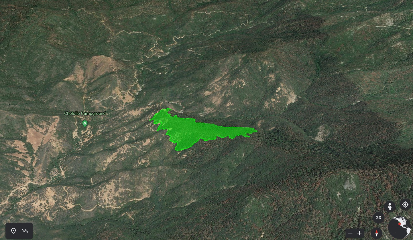
Windy just mapped by Intel 24 at 115 acres with active fire behavior.
6 Likes
I now hear AA over the Windy with tankers 73,74.They are flying this incident on
Air-43 167.700. AA430 enroute for relief at 15:00. Just added this to my scan list and caught this traffic.
Sounds like command traffic is saying this is a walk in fire. Two hand crews arrived in the last hour.
Relief AA request in for lead plane @ 15:15. Going to bring in a big air show??
Peppermint fire is contained. FYI
6 Likes
BC21 advising Windy IC that there is a thirty acre fire on the reservation that the heal is in TIA but the head of the fire is coming onto the forest.
Made it sound separate from the Windy. I don’t see other heat on caltopo:
https://caltopo.com/map.html#ll=36.04861,-118.65028&z=13&b=t&o=f16a%2Cr&n=1,0.25&a=mba%2Csma%2Cfire%2Cmodis_mp%2Cwxd_wspd-01
1 Like
Update on Crawford Fire: approx 3/4 acres at 36°4.462’ N, 118°35.650’ W. Took much of the day to access but scratch line is in and it got pounded with aircraft as well.
5 Likes