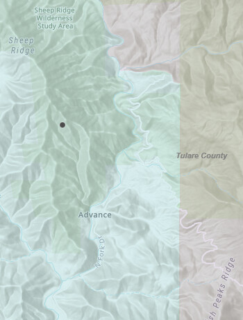
Got a couple helicopters with AA and 4 tankers working in the sheep ridge wilderness study area.

3 Likes
This has been burning for about 2hours in a remote location and access problems.
Exact I don’t know. Command is on CDF Command 1 tone 14- 151.355.
Aircraft on CDF A/T 23- 151.3025, CDF Tac 40- 151.475 for ground crews
4 Likes
Who’s WSA? BLM?
2 Likes
I’m pretty sure it’s BLM land
4 Likes
When in doubt of DPA use the following link and it’ll tell ya ![]()
https://nifc.maps.arcgis.com/apps/webappviewer/index.html?id=f62c0156e48047f59791293aa794b0f3
4 Likes
If it’s on Sheep Ridge in the study area it will BLM ownership but State DPA, west of the North fork. NPS / FED DPA is east side of the north fork, USFS / FED DPA is north of the fire a little ways
5 Likes
AA reports boxed by retardant, completing some double up.
10 Acres grass and brush.
2 Hand crews walking in. No road access.
4 Likes
Yep, but not sure if it’s in the Study area. Been a while since I’ve dealt with those boundaries. Back in the day we (CF ) were on most all dispatches to that area along with the NPS, but it’s been years. I’m ancient lol. I’m not up on current cooperative agreements anymore.

2 Likes
Either way, the hike in “ain’t pretty” ![]()
7 Likes
Holding at 16 Acres. Per AA.
7 Likes
They sent C-609 out of Columbia along with Tanker 82 & 83. I know 83 is back. I was wondering if this is a fly in or hike in show. Any access to get resources into that. When I saw it was sheep Wilderness figured it was gnarly ground.
Never mind reading the post gave me the answer.
4 Likes
C-609 back at Columbia. They stated the flew in cut an LZ and shuttled four hand crews in.
Airforce had pounded it pretty hard in the morning and afternoon They said it was steep, oak woodland, grass and brush. Not going to be a picnic tonight for the hand crews cutting line.
9 Likes