California Fire News & Weather

Sheds. This is a map of watersheds around El Capitan. The orange dot is Los Coches Creek gauge station. The color indicates ‘below normal’. As the crow flies to El Capitan Dam, in Cleveland National Forest, the watershed breaks, no less than, three times. The Creek, in fact, turns sharply north and approaches the reservoir on the north, not the southwest side.

I hazard that this is another example of riparian areas with complex waterflows with consequential fuels developments for summer. I think there will be some product next week from Boise on the three month outlook.

2 Likes
2 Likes

Tool: EcoAtlas: South Coast - Map

Includes sediment toxicity reporting.

1 Like

Abstract vegetation typology for a section of the Transverse Range recently featured in a photograph from Fire Aviation and an article in the LA Times.

Flying smarter to manage wildfires - Fire Aviation

2015-2022 Santa Anita Dam Spillway Modification [links to damsafety.org].

2019 Bobcat Fire burn scar areas [links to CIIMT1 arcgis wrapup].

Downstream (and up chimney) scrub oak, woodland/riparian montane, warming snow then drains through steep wash. Difficult topology as ff know well. Helipad. Owned by LA County Flood Control since Oct 2015. Surfer helo.

2 Likes

2020 Bobcat Fire Post Wildfire Debris Flow Hazard Assessment

2020 Bobcat, Ranch2 and Colby are loosely collected as 2020 San Gabriels Complex. After the fact, data from current situations and efforts can be compared to what was assessed previously. Clearly, the 2020 San Gabriels Complex cannot be blamed for all the dam-jams across the range, but it should be clear that risk assessments provide solid starting points for ongoing work and mitigation.

How does the assessment perform against events? Still early to say, over the long term, but the impact on Santa Anita Dam is clear and unambiguous. Recent projections predict that it will take 2 years to clear the current loads. Although the reddest parts of the map are on the southern exposure, Highway 39 on the northern exposure is as often closed as open, (Highway 1 on the Big Sur coast is another), and this will be a problem going even unto Spring as some hazards aren’t even accessible, yet.

Tool: CA Dept of Conservation: Recent Landslide Hazard Assessments

Includes a link to a crowdsourced recently Reported Landslides Map:
Reported California Landslides

4 Likes

image

2 Likes

Firefighter sucked into storm drain and swept to sea, officials say

"HONOLULU (KHNL/Gray News) - A firefighter in Hawaii was critically injured Friday after being sucked into a 4-foot wide storm drain and swept to sea during heavy rains, authorities said.

KHNL reports the firefighter was helping to clear out the storm drain near Waiapo Street in Kihei when he was sucked in. He was then carried about 800 yards by storm waters to where the drain emptied into the ocean.

Officials said the firefighter was tracked to where the storm drain would end up, and he was pulled out minutes later. He was found unresponsive but gained his pulse back after medical personnel performed CPR on him.

The firefighter was taken to Maui Medical Center, where he remains in critical condition.

An investigation into the incident is ongoing, officials said.

Copyright 2023 KHNL/KGMB via Gray Media Group, Inc. All rights reserved."

2 Likes

I’m obviously about some things that seem to be dead issues, here. Perhaps, when high fire season comes, there will be things to learn and share on a national level. For now, you sleep.

So, I’m glad the federal firefighters got some recognition, some health insurance, and some pay. We were all pulling for it. Sad news about Bill Gabbart. It’s good to see the Guard developing a strong fire program.

And, of course, it’s good to see happy Corpmembers. Go County.

Remember, when your instincts fail, trust your training.

ghost7 [medium.com/@xk051]

1 Like

After 30 fire seasons, my non-researched, anecdotal opinion is that winter weather is a poor predictor of how fire season is going to be.
If we have especially hot, dry windy weather in the summer, we’ll have an especially busy fire season. If we have a mild summer where heat doesn’t usually come with winds, we’ll have a relatively slow summer. This is the case no matter what happened in the winter/spring before.

9 Likes
1 Like

Is there an FRA hazard map for homes surrounded by national forest ?

1 Like
1 Like

https://www.sacbee.com/news/california/water-and-drought/article272271843.htm

1 Like

Had some nice mammatus clouds about 5pm with a few snow flakes.


6 Likes
2 Likes

Wind has been gusting 30-40 here at Millerton lake today.

5 Likes
2 Likes

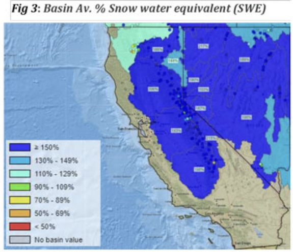
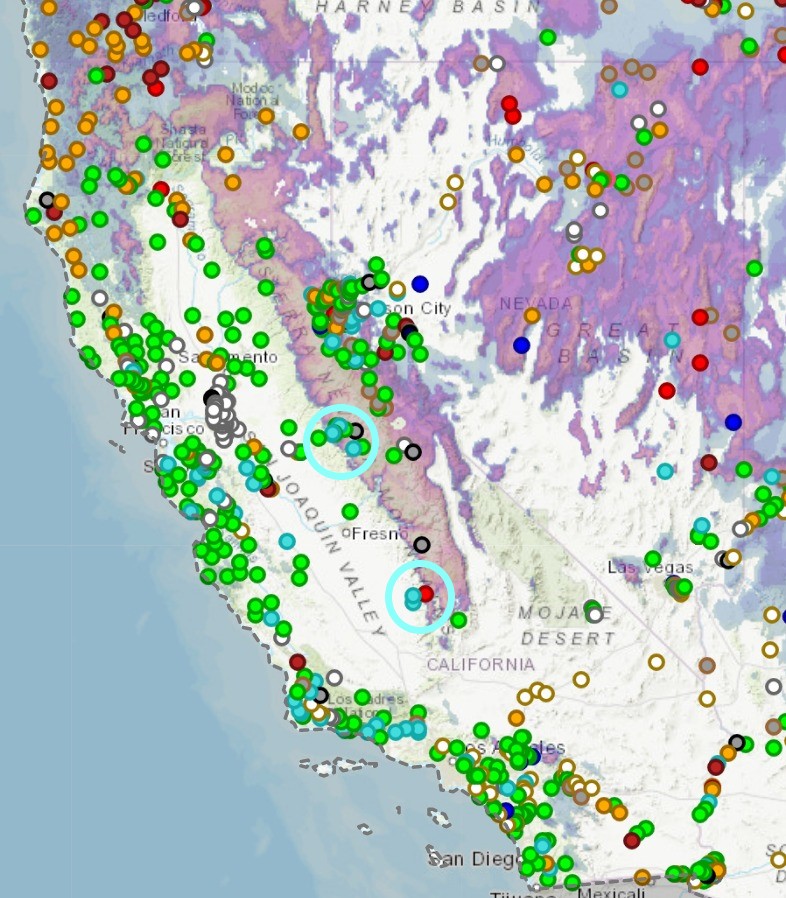
Two places, Madera foothills, more or less, where streamflow is above ‘normal’. Flow has been above normal, particularly around the circle I drew on the south end of the Madera foothills, more or less. I think we should still expect this flow to be above normal because we got, like what, 130% above nominal snowpack this year.

Before the drought argument, where you say that’s 130% minus the previous deficit, its not minus that deficit because that snow is still there and will runoff. We should, I think, expect increased runoff without having to stipulate that it is increased and unaccounted snowmelt, over and above the increased snowpack, and its probably still too early for that.

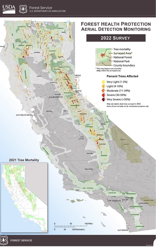
In my layman’s view, this indicates that even a nominal (normal) runoff is going to look unusual, particularly where other circumstances, dead and down trees, altered water flow due to flood damage, or alteration of the channel, are factors.

These factors have to be accounted for before declaring a specifically unusual runoff pattern of unusual melting. If it gets warm and stays warm, it will melt faster, but, again, there isn’t much of a mystery there to solve.

In addition, the wildfires were at higher elevations, to be sure, but so was the three years of drought that contributed to Dixie and Caldor, which I think may account for a majority of those elevation numbers, particularly Dixie, which is especially noted for how far east it went.

2 Likes
2 Likes