All,
I’m curious to what the fuels are looking like up and down the state in your areas. So Cal got a late season storm a few weeks back that dumped 6+ inches of rain. It produced another grass crop on top of the one that never burned last year. With the recent warming trend the past 14 days, the grass is turning nicely. Still a few weeks out for any light IA.
2 Likes
The Alert Wildfire cameras are an interesting way to get a feeling for what is going on with the drying of the fine fuels. I had a breeze through the cameras yesterday. Just as you say Flapjack, SoCal looks considerably greener than many places in the north. And indeed, there have been a few grass fires showing up over the last two weeks.
2 Likes
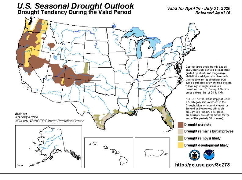
May 2nd, 2020
- Department of Water Resources conducted its final snow survey of the water year at Tahoe’s Phillips Station and the results provided a depressing outlook to the state’s water prospects for the immediate future. The survey recorded 1.5 inches of snow depth and a snow water equivalent of 0.5 inches, which is 3 percent of the May average for this location.
While the snowpack in Tahoe is paltry, the statewide outlook is a little better at 37 percent of the May average.
“March and April storms brought needed snow to the Sierras, with the snowpack reaching its peak on April 9, however those gains were not nearly enough to offset a very dry January and February,” “The last two weeks have seen increased temperatures leading to a rapid reduction of the snowpack. Snowmelt runoff into the reservoirs is forecasted to be below average.”
Dry conditions in October and November were followed by precipitation in December that measured 120 percent of average. Very dry conditions returned to much of the state in January and February, with March and April storms leading to the snowpack peaking at just 66 percent of average on April 9.
The state’s six largest reservoirs currently hold between 83 percent (San Luis) and 126 percent (Melones) of their historical averages for this date. Lake Shasta, California’s largest surface reservoir, is 94 percent of its historical average and sits at 81 percent of capacity.
4 Likes
The northern 1/2 of the state is dry and the northern 1/3 is really dry. FM in the brush in some areas are running around 92% and dropping- 80 being critical.
There are escaped controlled burns almost everyday in the foothills above 2500 feet- the timber litter is burning.
Grass is beginning to cure below 1000 feet, and this weeks heat should kick off the grass crop below 2000 feet.
In many areas the Manzanita already flowered. In my neck of the woods at 2100 feet-the Buckeye is starting to flower. It usually drops its leaves on a normal year around the 4th of July or a week or so after. In 2008 it did it on Memorial day- we know what happened then…
Most fuel moisture readings are suggesting that things are 5-6 weeks ahead of schedule- so we will see. Watch the Buckeye and the Poison Oak… those are your visual indicators…
13 Likes
Thanks NorCal, great assessment.
1 Like
http://www.wfas.net/index.php/national-fuel-moisture-database-moisture-drought-103
Here is the National Fuel Moisture Database website to see all the different sites that track fuel moistures.
4 Likes
Took a drive from Sac up to Ft Bragg across to Willits on the 20 back down the 101 towards the north bay…I know where i will be spending this summer on assignment…
4 Likes
Been keeping bees in Ione and Placerville for last few months with plenty of grass and vegetation growth. Decent honey crop and heavy rains in March and April in Placerville has made for some very tall grass. A storm in late March along Highway 88 blew down a lot of branches on previously treated prescribed fire from about 4,000 feet to 6500 along the 88 corridor where the highway follows the ridge. It is all so green and beautiful on the 88, 49, and 50 between Jackson and Placerville as of now, but when it drys out there is a heavy fuel load.
1 Like
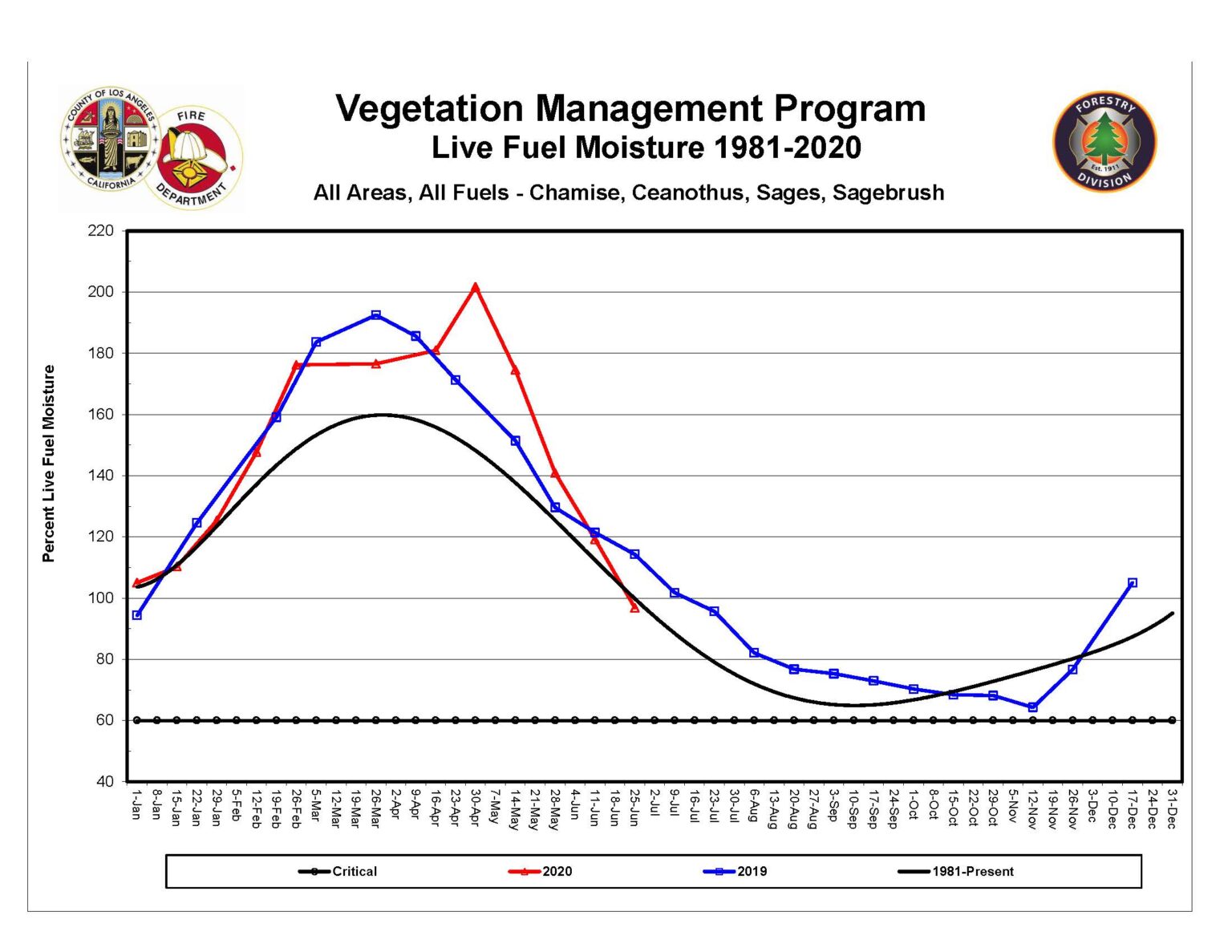
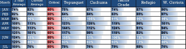
LA County fuel moistures have dropped below the historical trend line, following an above normal peak and later than average peak. The fuel load this year is empirically much larger based on relative greenness and the late spring rains.
The cause for the large drying of the fuels has been very amplified weather across the entire US, the amplified pattern caused above normal N-NW winds across the region, including a rare very late season NE Santa Ana wind event. The pattern has also left a decreased amount of marine layer and ‘may gray’ or ‘June gloom’ days leading to further drying of fuels.
https://fire.lacounty.gov/wp-content/uploads/2020/06/All-Areas-Graph.pdf
4 Likes
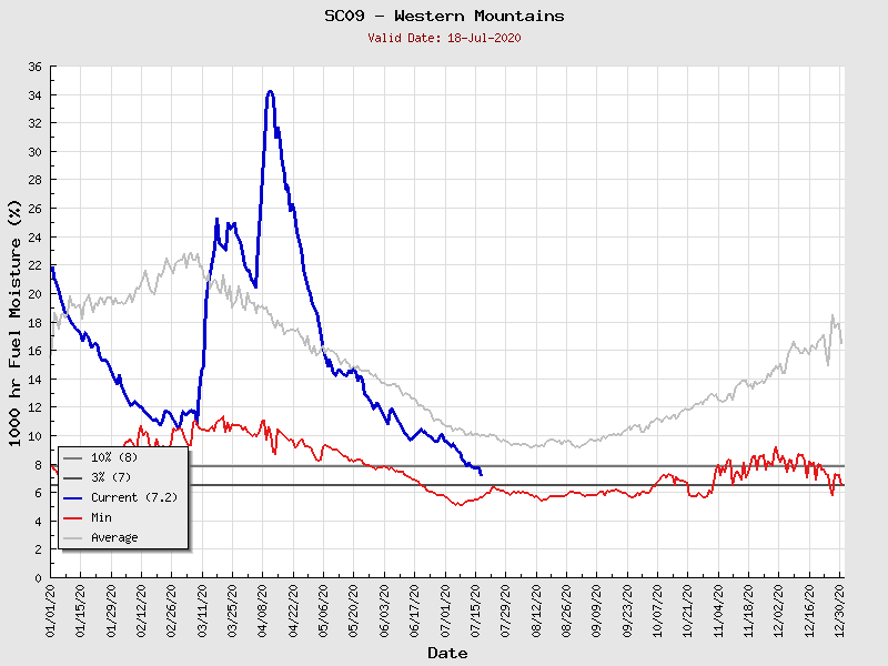
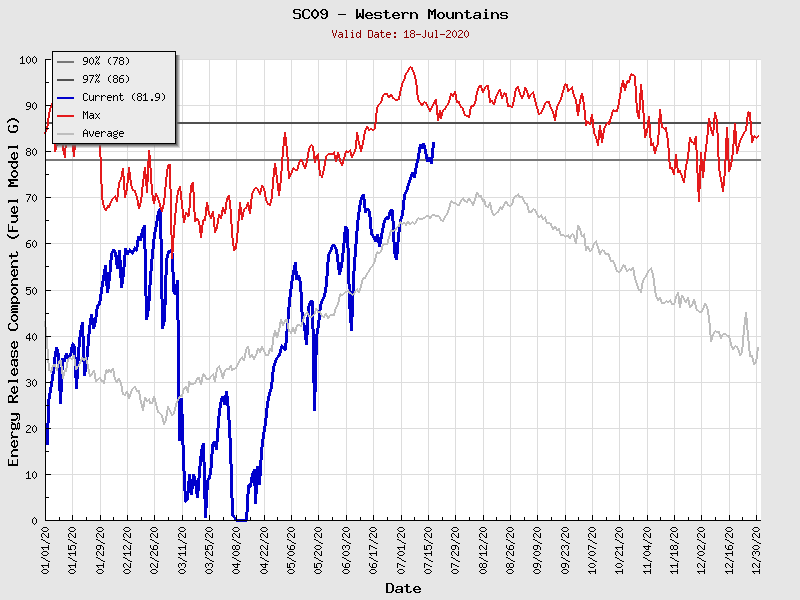
This year has been parabolic, this is reflected in almost every zone with the later than average and higher than average fuel moisture and then intense drying. 1000 hr fuels are now at or just above critical stage in many areas. This zone is approaching the record driest 1000 hr fuel moisture.
Energy release components also continue to increase and approach the record highs.
Santa Barbara county average Live Fuel Moistures are running at 76% which is 33% below the 3 year average. Just above critical.
4 Likes