Private message and I can get it to you.
made a down and dirty updated tutorial for making geopdf into geotiff for google earth or atak. Working on a google earth tutorial for the tiffs.
Here is ftp site https://ftp.nifc.gov/public/incident_specific_data/
Here is tutorial
https://drive.google.com/drive/folders/1PI9iCqo4Y7rAmTdbJEO2smpfRPKxSpN5?usp=sharing
Updated some tutorial stuff I added another document on using geotiffs in Google Earth.
https://drive.google.com/drive/folders/1PI9iCqo4Y7rAmTdbJEO2smpfRPKxSpN5?usp=sharing
Some new videos on ATAK -
Here is a video of AA51 footage in ATAK from the other night on the Rowher incident. DPA layer turned on and the perimeter polygon. Additionally 3D on so you can tilt the map.
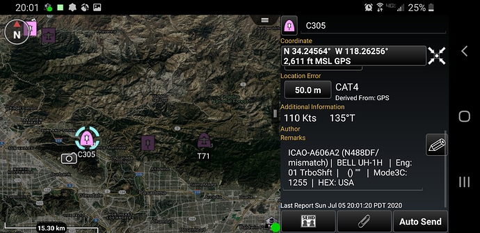
Another cool thing about TAK is the ability to port in ADS-B broadcasting from Aircraft. This updates about every 3 seconds. Here is a screen shot of a new solution we are working on. This is aircraft on the Soledad fire in Los Angeles County. You can see its bringing up CAL-FIRE Copter 305. You get a lot of metadata with it as well.
Just an update. I have been fielding a bunch of questions on ATAK.
Its Android only for now. iTAK coming soon. Its on its second attempt and looking like this time its gonna go.
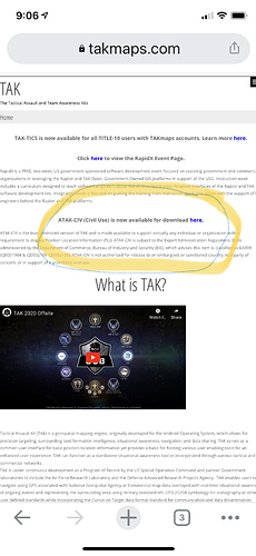
www.takmaps.com you can download ATAK-Civ and that gets you full version. You have to register with a .gov account to get extra plugins for now. You really dont need them right off the bat. Hoping all of this on the playstore within the year.
AJ, thank you for taking the time to inform us! Please keep it coming!
how about early august i do a little webinar on it, just about finished with grad school and then will have the time,. if you need help in this thread there are links to help guides on atak, youtube videos etc,
ok I have read through the thread, how do I go about aquiring ATAK?
Go to takmaps.com and download it. I will do a webinar in first week of august to help everyone through it. There are resource links in the thread about video sources for training and some of my agencies power points.
Appreciate it, started the registration, just looking for the download link
It right there above the video its in blue letters.
Thanks, tried that and got a warning, i will sort through it, thanks for all the help
A webinar of this gem would be quite useful. Such a powerful tool.
a strong YES to a webinar!
Webinar it is! Until then there is good stuff on this youtube channel https://www.youtube.com/channel/UCbiFR6MiKBtUOMdn5SbXE-g/videos
So as far as mapping is concerned check this out if you want.
Here is a link to a google drive folder for mapping examples for TAK.
https://drive.google.com/drive/folders/1GuY-MVWnlo3vlM7FEiDn8Nd3H_AXMpKn?usp=sharing
I added the Numbers incident data this morning into a data package.
A Data Package is a zipped folder that can have multiple items. In this Data Package is the IR topo map produced from last nights flight and the IR KMZ file of the heat signature. Its listed as a zip file and says DP in the title.
Download the zipped file to your device. Do NOT unzip it.
In ATAK go to the import tool, browse your device to find this DATA PACKAGE and import into your device.
Its going to ask how to import. Choose Data Package -
Now you have a couple ways to find the map data.
Go to the DATA PACKAGE area of ATAK open it up and you will see the DP there and open it up and click on any of the maps or the kmz it will fly right there.
You can also go to the overlay menu and choose Image Overlay which will have the map product or the File overlay and it will have the kmz.
Give it a try and see if it works for you.
I also added a folder with the AlertWIldfire Cameras. use the import function to bring in the cameras. to play the camera click on the camera icon. you will get a radial menu. Then press play button.
This program takes some getting to know but once its your daily driver for intel you will enjoy it.
See you guys on a webinar in early august and I will continue to make some maps for the larger fires. You can also make your own maps. In this thread there is a link to a turorial on how to convert the fire pdf maps into tif maps for ATAK to use.
AJ
Thus ATAK seems really awesome but very overwhelming. I have not delved into the tutorials yet but was wondering how user friendly it is for non-techies. I’m good with Avenza and navigating the FTP site. I’m single resource and my dept is newly reintroduced to the T3 game.
Like anything the more you use it the more comfortable you become. You dont have to use it for anything more than a map if you want or you can explore a lot of the geospatial tools and plugins.


