Like anything the more you use it the more comfortable you become. You dont have to use it for anything more than a map if you want or you can explore a lot of the geospatial tools and plugins.
1 Like
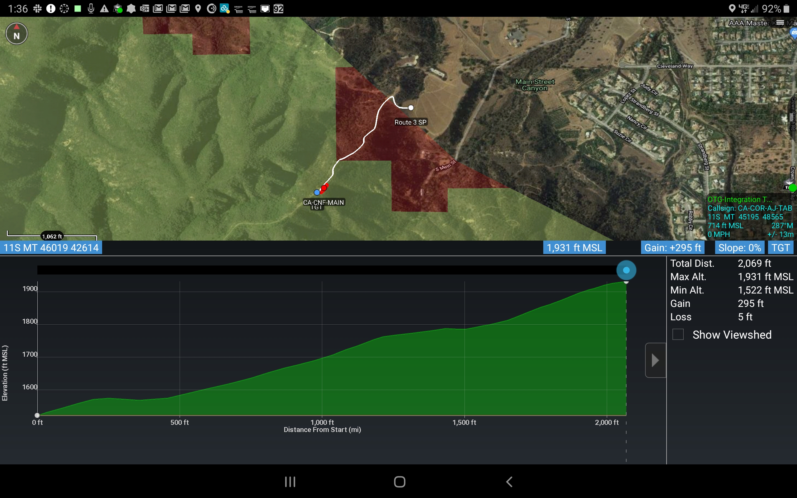
Cool use for ATAK. Last night we had a small fire outside of our city on the Cleveland. It was after hours and CNF was on a call back. We showed up first and two type 3 crews hiked in a little under a half mile with tools and saws to get to work on it. We knew we needed to get a hose line up there to mop it all up. The question always is how far is the hose lay for the crews that are bringing that in. The “Route Tool” in ATAK can allow you to draw a route back down to where your pumping operation is and give you the length of the hose lay and your elevation gain. Here is a pic from last nights fire. We had LTE so we mapped it in ATAK and exported a KMZ. and emailed the CAL-FIRE BC in charge of operations the file as well as some screen shots showing the DPA. Lots of cool stuff built in this for wildfire
4 Likes
updated the alertwildfire camera data package as they have added some more cameras.
You can load this one and delete the other one.
Also dropped a KML for repeater site info.Its from the same database that force readiness uses. Hit the icon and then the radial menu will come up. If you select the icon that looks like a pad of paper you will get tone info etc. What I really want is an ATAK plugin that acts like the tone/zone on force readiness
https://drive.google.com/drive/folders/1GuY-MVWnlo3vlM7FEiDn8Nd3H_AXMpKn?usp=sharing
Does anyone have a link for all the WX stations that Edison and PG&E are putting in in conjunction with the alert.wildfire cams?
1 Like
Decent LTE coverage on the HOG with Verizon on the line. Two of our ATAK users from Corona Fire being able to exchange data, location etc.
1 Like
This video shows a geospatial tif image of a small grass fire we had recently. We used Pix4D React software for processing the imagery collected from one of our saus platforms. We flew the incident, processed the imagery right there in the field on a laptop, and then shared the imagery over LTE into our ATAK network. From flight to end user was 20 minutes. Yellow border is city boundary and red shading is RRU-SRA.
1 Like
Hi all, schools out for the rest of my life now and as promissed Im going to look for a day sometime this month when things calm down to do a webinar on ATAK. Until then there are tons of videos published right on youtube on how to use the tool. I have loaded DTED for CA, AZ, CO and WY on to the google drive. DTED is digital terrain elevation data, it gives you that 3D view in ATAK. There is a video tutorial in the youtube site on how to import this data into ATAK. I am still uploading the files so give it some time for the DTED files to show up. I also made a tinyurl to get to all the data. I will continue to support incidents the best I can. Ultimate goal is for this to be a standard in GEO-OPS.
4 Likes
Forgot to mention there is a news release of some sort on August 4th on iTAK 2.0. I will be sure to share with you what we find out. iTAK will get this in the rest of your simple minded hands…j.k. I have an iphone too. Im typing this from a Mac as well. I have em all lol. Im pretty excited about this getting much more of an audience in wildfire and public safety in general.
2 Likes
New AlertWildfire Camera data package for ATAK.
2 Likes
Also totally forgot within a data package you can have a pdf file (by pdf I mean like a readable document like the IAP not a geospatial pdf map, ATAK uses geotiffs). So total one stop shopping. All your maps, kmls, videos, documents in one download right into TAK. I will start adding the IAPs tomorrow when I build data packages. If you want to check it out I posted an updated one for the Apple with the IAP in it. It uses the same file name so be sure to delete the original off your device then add this one.
2 Likes
Well looks like not a lot released on iTAK today, looks like more to come in a couple weeks.
1 Like
Well, as a IOS user, I would say that the release of 2.0
Is pretty significant. Been looking forward to being able to touch and feel the product but didn’t have the capability.
1 Like
Oh yeah its going to open up a tool to you that your gonna love. Its Avenza on steroids and can be connected to other users in a group. Even stand alone without connectivity to other users its a slick tool. Cant wait for it to get in more peoples hands.
4 Likes
What is the name of the app for iOS?
iTAK its not out. I will let you guys know when its released. The whole suite of products is called TAK (Team Awareness Kit) for the civilian side and (Tactical Assault Kit) for the DoD side. ATAK is Android, iTAK is for iOS aka Apple.
4 Likes
Uploaded CA DPA kmz to the data folders at https://tinyurl.com/TAKMAPS
This came from FRAP, I noticed some things like the entire chino hills state park not showing up as state DPA in ArcPro I will look into that more but I think its a pretty decent data set. For now it should work pretty well for CA users.
1 Like
I was able to download iTAK from the APP store this afternoon. Is this an old version?
Please send me a screen shot I do not see it on app store, and spoke about it today with the tak product center and it is not released and still in development at this point.
There is an app called iTAK in the Apple Ap Store but it is for a different developer.