If it doesnt have this logo its not what your looking for 
3 Likes
Thanks, The APP I downloaded was from SITREP, which also uses iTAK as a label.
NOT what you want. I will be waiting for your word of the iOS release.
1 Like
AJ, I apologize if the answer to my question is in one of your sources……but, after you import a map like the DPA then close the app out do you always have to re import every time you close and open the app? Anyway to save all your imports?
Where did you import aircraft tracking from?
@FSFF once you import anything its on your device you dont have to import again. The only thing that would say need to be “refreshed” are things that reach out to the web to get their realtime info like for example you can bring in modis as a kml network link. If you want to get the latest you would tell the program to refresh that link. Once you program the link its always there but you will have to tell it to “stream” when you want it to.
Aircraft is done using ADSB and right now the FBI is working on a more robust hardware solution to make it more stable. The way it works is the ADSB receiver picks up the aircraft callsign and then it pushes that info into a TAK server. In order for you to see that info you must be connected to that TAK server in some fashion or there is another option where you take that same hardware and hook it to your ATAK device there is a plugin for ATAK where it will broadcast the aircraft info out over a TAK server.
A bit about networking. ATAK will work peer to peer so if your on the same wifi network you will see other ATAK users. So you could use a VPN service to see other users miles away from each other if they were using LTE but on a shared VPN.
USFS is working on a TAK server for evaluation to try out for feasibility. If you are dying to try to be connected there is TeamConnect for ATAK which is what my FD uses. 100 bucks a year a device and you can have devices connect to each other.
4 Likes
Great news story from our friends at CoE. Hopefully this is coming to California.
1 Like
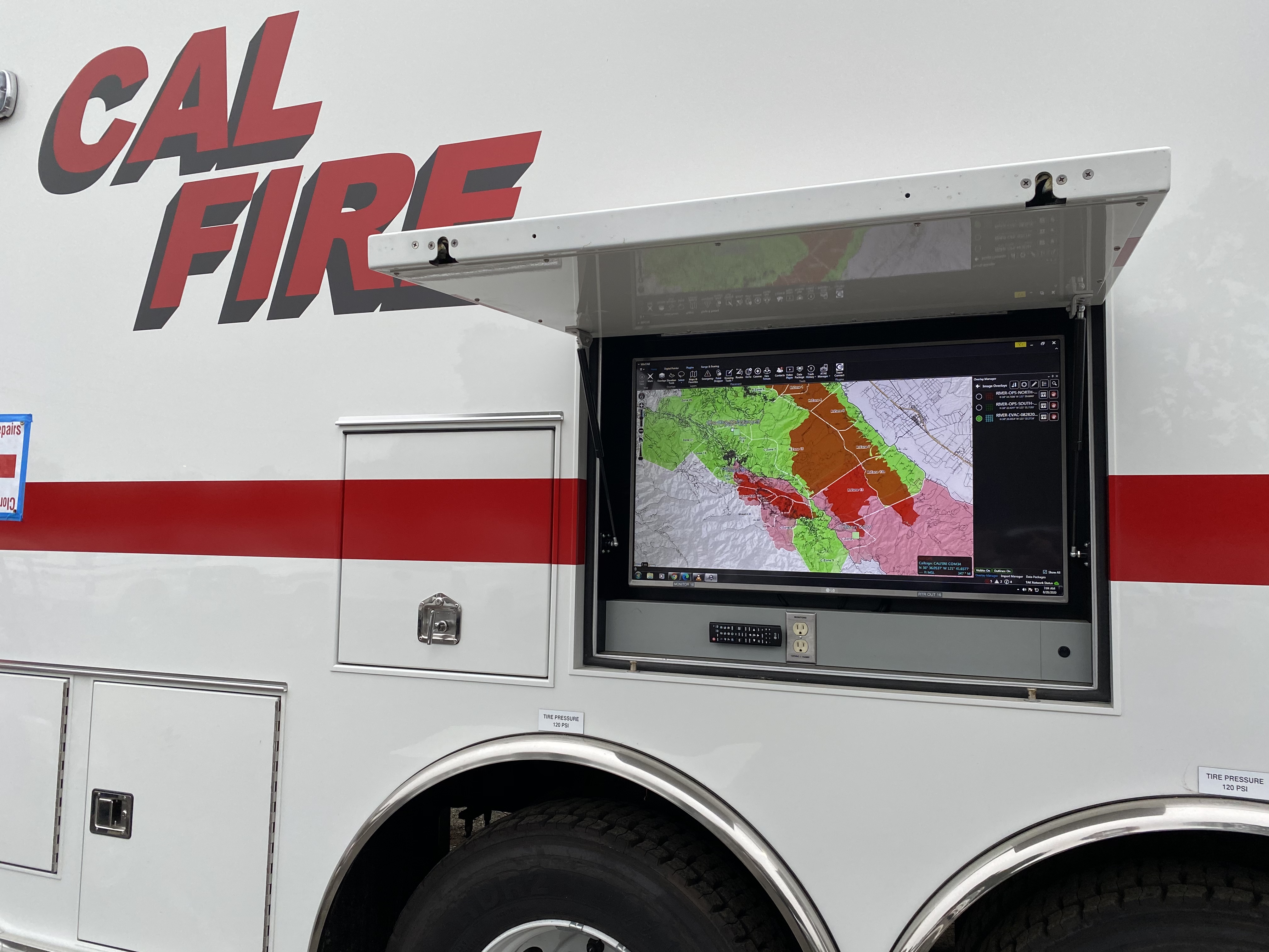
Hey ATAK users I uploaded some geospatial video and the ops map from the Thomas Fire. Go to the Video folder and download the DP-Thomas Fire file. Dont unzip it. Then import into ATAK.
This is the first ops map of the incident and whats cool is you can play the video and the aircraft position will show as wells as sensor point of interest aka SPI on the map. Gives you an idea of what can be done with geospatial video. You can also click on the SPI and have it drop bread crumbs. In the next version of ATAK out very soon you can change the color of the breadcrumb. That was a direct change from the wildfire community so we can change depending on your basemap of choice. Its currently white which is difficult to see if you have it over an ops map. If the sensor operator is tracing the fire edge and able to live stream the video you could map on the fly. Enjoy.
4 Likes
Been working with AJ and Conner the last few days in ATAK and I must say, the possibilities are endless. In camp, intel has the opportunity to become much faster. I am looking forward to some of the tools available out on the line as a STEN in the future. Thanks AJ and all those involved in getting this to the field.
5 Likes
It’s been a pleasure working @eng1ine and the rest of the folks on the LNU and BEU fires testing out ATAK. Hoping to see the real time situational awareness tool set grow for us with shared geospatial intel. You guys working on Comm 34 knocked it out of the park with ATAK running on an amazon firestick!
5 Likes
Any updates on when this will be useable with iOS?
2 Likes
I think probably late this year early next year. DHS really wants to get this right and they are not gonna rush it. Nice thing is this time around apple is involved. We just have to wait for now but seriously go buy an android tablet and tether to your phone. I have watched 10 people do that in the last 2 weeks. Make sure you get one with a compass and gps radio.
Another tidbit to remember is as of now TAK will not take a geo referenced pdf. The maps must be converted to a geotif or the GIS shop has to export as a tif. This does not take long but just beware.
4 Likes
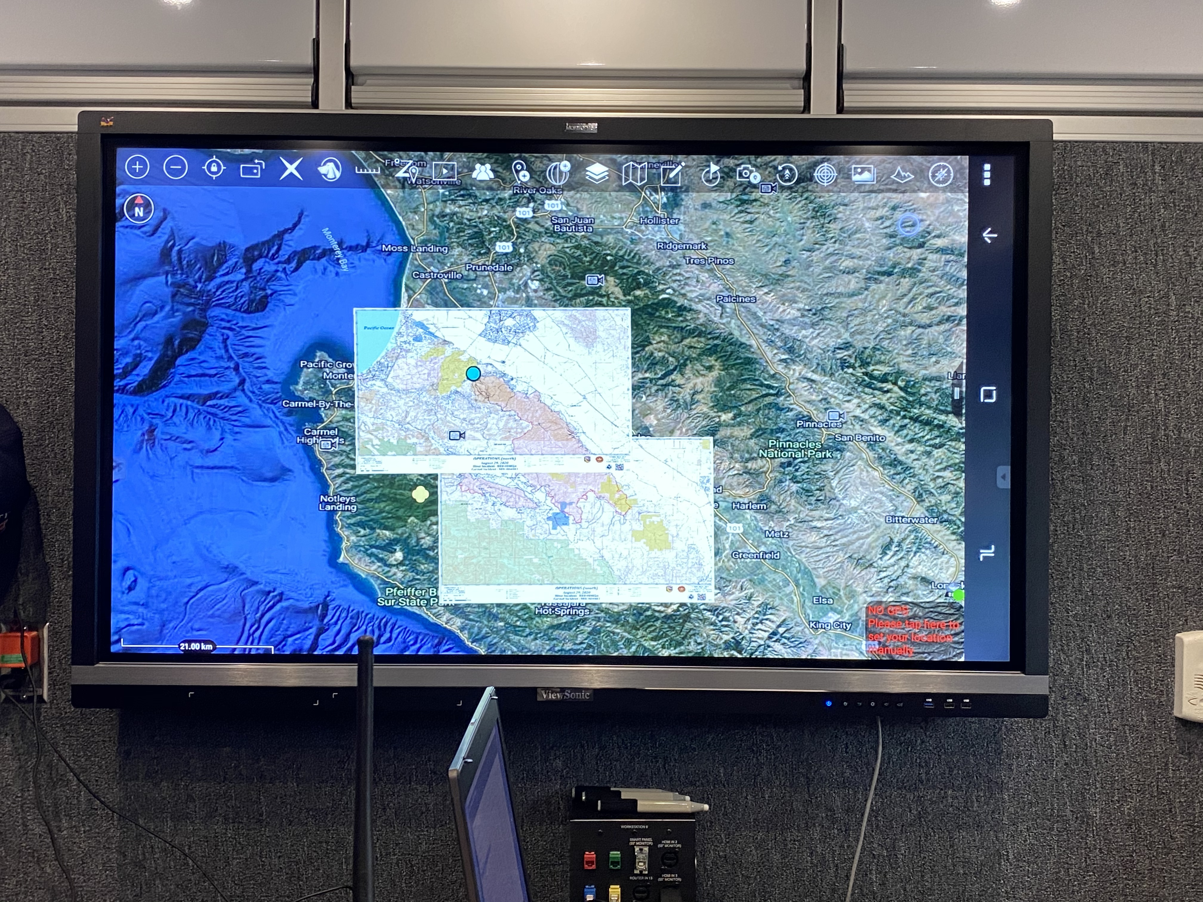
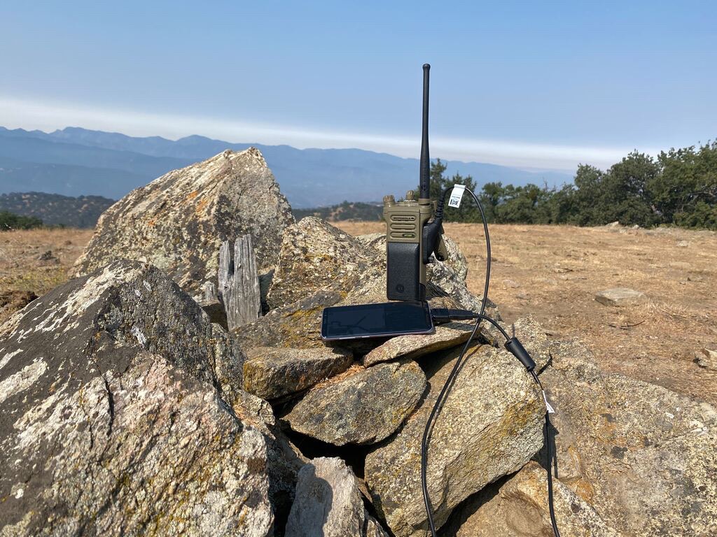
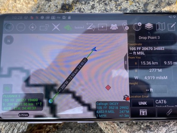
We had some cool success this past week working with @DC3075 testing ATAK in cellular denied environments and using VHF radio to send positions, polygons, points and chat. Here is a couple pics and a video of the set up. This is done over a Motorola APX Radio using a side program running on the Android device called Plugnix from KeySquare Labs. It’s done using digital P25 protocol. The cool thing is the data channel doesn’t have to be the same as your voice channel. With dual and Tri band radios the possibilities are pretty cool. The next step is testing over repeaters. We got 12 kilometers direct line of sight passing the data. Basically if you can hear someone on a direct channel you would be able to see them in ATAK.

9 Likes
This is a Service Bulletin from BK Technologies on the Sortware for the KNG SERIES RADIO. 5 .6 software is CORRUPT and it needs to be downgraded to 5.5.9 or less.
BKSB-1057 5.6 Software Issue.pdf (246.0 KB)
3 Likes
Here it is! ATAK now on the Play Store.
6 Likes
if you want to be able to clone on a Calfire incident, you better be running 5.5.3 the RELMS software page that says CF.
3 Likes
And then there’s this –
1 Like
This is aimed at smaller drones that do add to the fight but IMHO we need more Type 1UAS with long endurance with data links and or more manned aircraft for 24 hour ISR with data links. I would
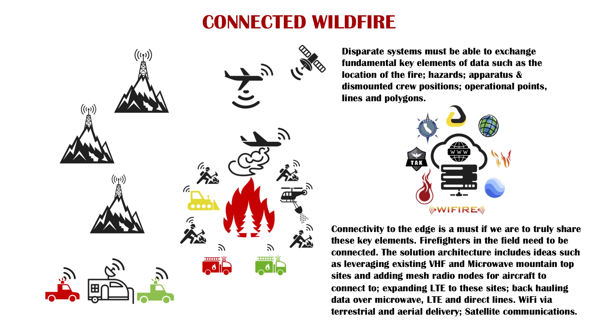
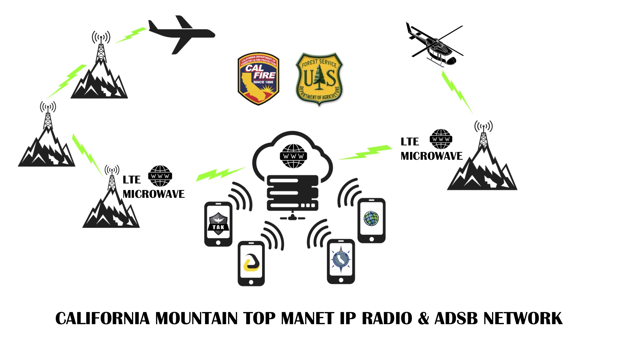
love to see a mountain top network of data links using L/S band radios on our existing repeater sites with a way to back haul to the web. No need for a data van to have to chase down an aircraft to get data. We could use the sat comms we have now but bandwidth is expensive for sending stuff like video. Lots of new sat networks coming on line though like starlink. However the radio thing could totally be done now as we have so many radio sites already. Made some schematics up a few weeks back.
5 Likes
Another big part of this is forecast modeling. So having the aircraft/satellite sensors, with weather data feeding modeling programs that can output a visual reference of where the fire will be going in certain time frames. We can take this output and export it to on scene commanders to help with their operational decisions for control and evacuation purposes.
2 Likes
That would certainly be an interesting mesh of public, and private infrastructure. (speaking for California) The only microwave network around for that is the state’s, and I’m sure that would be a pretty penny to jump onto. And then what would the handoff be between aircraft and mountain top? You have the state OV-10’s but federal ships and extended are typically contract aircraft. Adding external video capabilities (and/or mesh networking avionics) to those is a huge private undertaking. Courtney Aviation out of Columbia can pull video off and I think it’s a mixture of of cell and sat, but haven’t seen much demand on that this season. If they put it on the OV-10, how does that change their mission profile? They’re in a hard bank putting the aircraft in whatever position is needed to choreograph the airspace, now they need to worry about camera angles? Who wins the backseat pilot on that? ATGS or the IC on the ground? This is where that UAS at a dedicated orbit would be nice.
As much as this pains me to say this, a lot, this sounds like an excellent opportunity for expanding First Net deeper into the forest. There’s your already established private/public relationship. Bandwidth is there. Heck, site it on some state or federal towers and make it First Net only, or do that backroom trade deal ATT and feds have where public can be served off the cell as long as First net has full priority on bandwidth. Imagine that extra ounce of call/texting support in a Camp Fire evac situation deep up a river canyon in a beetle killed forest on a holiday weekend…  Imagine all that disgusting cell equipment and bottom-dollar install quality in the way of our state and fed radio techs.
I’m rarely a debby downer, and I sound like one here. There’s just, a LOT, of hurdles here. I’d fully support whatever, but for our terrain for now it sounds more like a Starlink goal…
4 Likes
@norcalscan thanks for your response all valid points.
- I would never task an ATGS for ISR. This needs to be a separate aircraft manned or unmanned top of the stack out of tactical aircraft traffic
- Courntey is pushing video but because of bandwidth they cannot push live unless connected to their mesh radio on their van hence my proposal for the mesh network radios as the hand off between aircraft and ground node. We could put these mesh radios on on our existing infrastructure so we can have good coverage and potential to build out the backhaul. USFS AA-51 and the Cobras also capable of video. AA-51 does video clips and sends them out via email and they are narrated. Pretty nice SA product but they have to get back to send it out. If they had high bandwidth could send it airborne. Cobras have a mesh downlink using persistent systems MPU5 solution.
- Airborne cell has potential and there are companies that can provide it to everyone on the ground and even push band 14. So like you mentioned this aircraft could be dual purpose overhead. Build the connectivity bubble and also send data. But they have to be overhead so if they have multiple missions the ground folks loose their network if they were in a cell void. I really think companies like Somewear labs is the answer for the dismounted position location. They have a plugin for ATAK and it can send position, chat, points, lines, polygons.
- Your not a debbie downer all things require 360 views, pros, cons but the discussions need to be had. If it is mesh radio the hardest part will be which solution we put on the mountain tops. The airforce does this over wide areas with persistent systems. Silvus also very popular.
4 Likes