
We can make a new thread called “Open Source Intel” or as the cool kids say OSINT. This will help out @beel who just wants some mapping info.
4 Likes
Any of the map data is only as current as the instant it’s captured. Much less accurate the instant it’s published. A lot less when it’s read. The published evacuation zones are good until they are updated.
When y’all start stating your need as your inner geek or station down time, I’m thinking Nunya. You got no business squeaking and agency bashing so loud for that.
Already inaccurate right after they post it? Then that sounds like undue risk to the pilot and an unnecessary mission to fly.  Why do it?
Tune out those few idiots that are agency bashing, they aren’t worth it, and it’ll help to see the bigger picture some of us are talking about amongst the parallel arguments/efforts/noise happening here.
1 Like
Any perimeter info, including FOBS and even flight data, on any incident is only as good as the instant it’s gathered. Is that not obvious? It can help with examining actual spread rates vs predicted, but as a justification for making that info instantaneously public, I don’t see the need when the entities with the info are using it to make officially released, public info available.
If an agency expands it’s access to info voluntarily or by court order, more power to you, but to complain about it here, meh.
And I hope your prepared when maps you’ve prepared and a website has published for you can be shown to cause someone to make a decision that has a negative outcome.
So I can understand some of that. I guess my follow up then would be why the flat out anger from some members when they don’t get updated maps daily on an extended or major incident? I mean if it’s a hobby then treat it as such. I like to golf but I don’t throw a tantrum when it rains.
5 Likes
Which then circles back to the other valid points being made in this thread, where one state agency provides the exact data some of us are looking for, within 10min of capture, even with a 15sec video narrative on twitter for crying out loud, while another plane 1500’ separation is simultaneously mapping, (and continues to map 3-4-5x a day) whose data was piped into outputs like caltopo and others until just a few months ago.
Round and round this thread goes, the same arguments and questions over and over, with the same low-effort shutdowns and in some cases a perception of holier-than-thou.
1 Like
I wholeheartedly agree - and I think there’s some parallel arguments in this thread that unfortunately dilute the voice of the adults in the room.
My direct answer to you, is what I stand by, with passion, and back it up with countless hours, days, weeks of service and action. The last two paragraphs were more tongue-in-cheek with the noise here and the typical WFI rowdiness of needing those maps to armchair QB the IC (or the IMT if one was ordered, which look to the 4th or 5th post in an IA thread for the IMT order status…)
5 Likes
Understood. And you answered my question so I appreciate that. I defiantly think it’s sad how quick agency bashing still shows up in this day and age and often over such trivial things.
1 Like
I’m not saying I know the specifics of this aerial mapping, I do know contracts for this kind of service may start out with one kind of release of info available during beta, then once out of trial stage and into production may switch to cost per audience size, etc.
BLM used to have a price to play for lightning data. No grudge on BLM, just saying.
1 Like
@bootstrap and @norcalscan i have just a couple questions;
- who is agency bashing? Identifying how one agency shares data is a fact. Identifying the barriers to said data is a fact.
- Inner geek? Only geeks use map data?
- Data is only good the instant its collected? All data becomes stale?
- Please explain a scenario where someone makes a decision off a fire perimeter that is shared to the public that cause a negative outcome because the same argument could be made to agency personnel as well. So maps arent good?
2 Likes
That’s an excellent point I hadn’t thought of. I don’t know specifics of the subscriptions for my agency either but that may very well play into it. Also, I’m not sure Courtney is out if the testing phase.
I’m regards to why sometimes it seems ok and other times it doesn’t to say, post a picture of a burning house, we’ve all been in the room or been the one who’s said, “welp f$&! It. It’s already out in the wild.”
1 Like
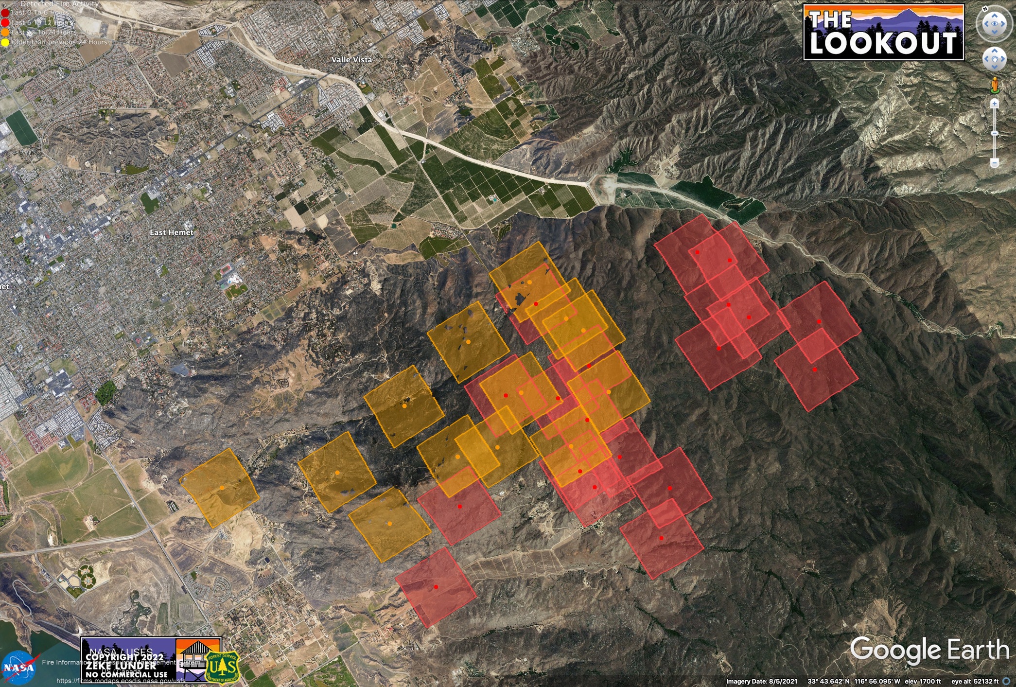
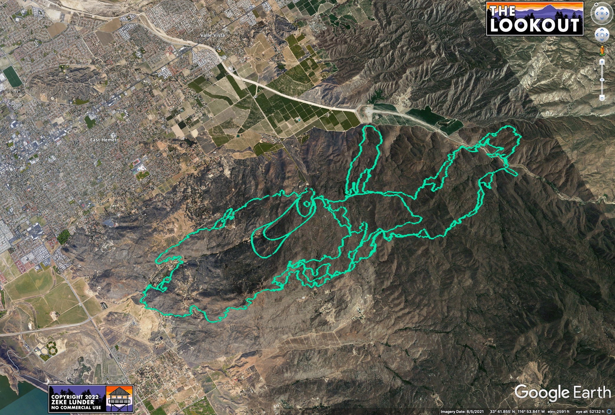
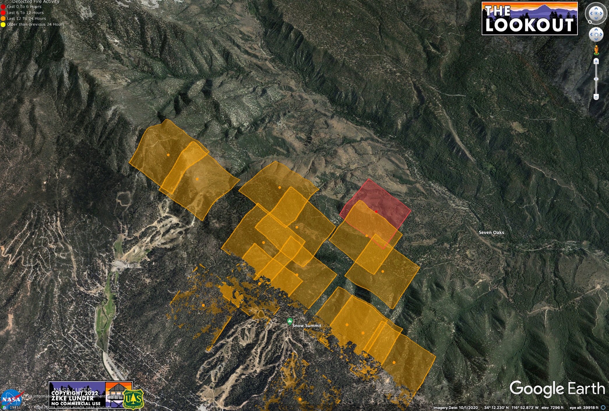
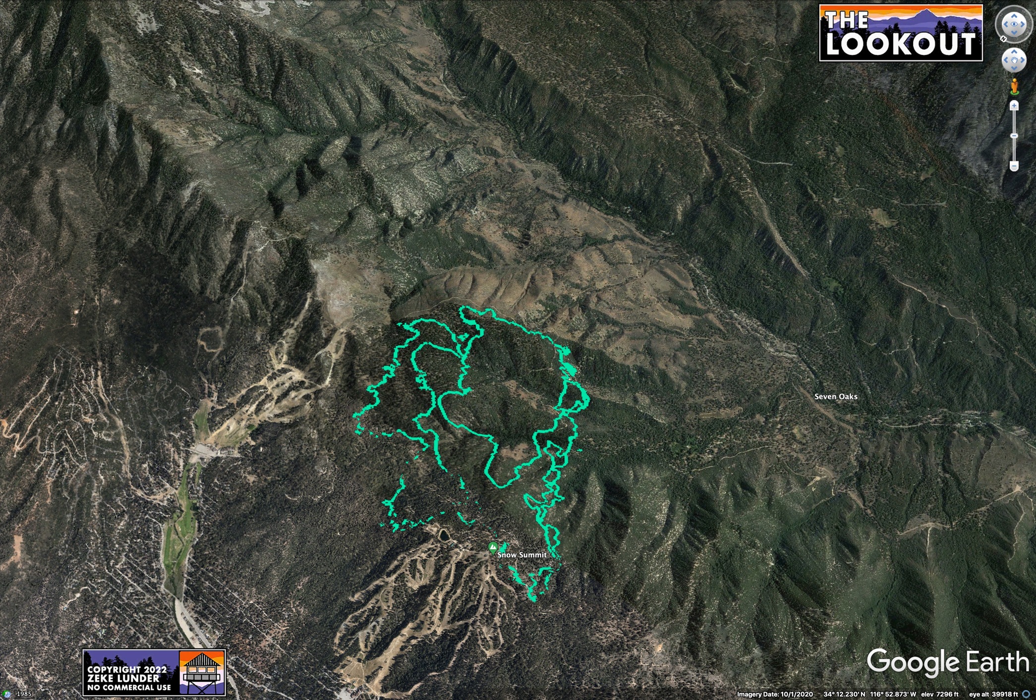
I think the maps tell the story pretty well. Here are two views of the Radley and Fairview Fires - both from publicly-available data captured this afternoon. The green line is FIRIS, which is the type of data some of us would like to see CAL FIRE releasing from their contract ships. The other maps are from MODIS, which is one of our only other options for automated fire data.
The media (including me) are going to publish maps of the fire using best available info.
Which imagery better serves the public? Do you think the Sheriff, animal rescue, inbound contractors, and evacuated public are better served by the images taken from deep space or the ones that are accurate within a few yards? What are the drawbacks of giving the public better data (that they are paying an arm and leg for, BTW)?
During McKinney Fire, the MODIS info was off by TENS OF THOUSANDS OF ACRES. People were panicking, and maps of this data were shared hundreds of thousands of times. Current MODIS of Radley Fire makes it look like the end of the world for Big Bear.
4 Likes
So part of the issue here may also again be budget. Cal Fire being ummm large, things are always more expensive to change. Or it could just be personal preference on the people releasing the maps.
You also make good points as well though regarding how you use the intel.
1 Like
@2ndLine1stWord I can tell you for a fact it is not a budget constraint for any agency. It is a policy/culture type decision. Nothing more. I do think things will change.
3 Likes
It makes a huge difference whether a mistake happens using info in house (fire personnel) vs public.
The info has to be vetted to be valid. Can’t tell you the number of times I’ve been out hiking for hours, searching for multiple spots over the line with a map from an IR flight and never find the spot. Whatever it was (hot rocks?) that looked like a heat signature wasn’t where it was supposed to be.
Can’t think of how many times I’ve read on here, be careful what you say, there’s a lot of experts on here. Once that’s established, you’re on the hook for the products you publish and you dont have boots on the ground vetting the raw data. No big pockets to save your butt. This tech, so far, is too young that an accident hasn’t happened yet.
I’m not hating on anybody for nerding out on this stuff. That was a reason given above for want of data. Push the boundaries of this stuff! Go for it! IMO, this professional forum isn’t the place to voice frustrations when the info isn’t released and you have no idea why. As an active firefighter, use your professionably available routes for answers. If that doesn’t work then maybe, it’s need to know, or nunya. Hell there’s tons of notes involved in decision making that go into the doc box that aren’t immediately public, or may never be.
When I’ve been out on recon/mapping flights, for whatever reason the pilot cut corners, or swung wide and I’ve had to estimate actual line when I got back to Sit. Just making the point of vetting and validation. I guess if media wants to contract its own flights, they own the data and use it how they will.
1 Like
One huge piece missing in this dialog is the law enforcement side of the fire response. Law is catching up (as in Fire is nearing the finish line and law just passed the first water station) in scaling their initial response to these large fires on day one. On multiple incidents this year already, and plenty in the past few years, there is a literal wall blocking information flow from fire discipline to law. Sometimes it’s accidental, others it’s ineptitude on one or both sides, and in others it the typical politics.
Speaking from the rooms where it happens at the Dixie to some recent 2022 lightning bust incidents, law has been in the dark as to where the fire has been, or is headed to, and their local tech gurus in the dept or their SAR team know where to find FIRIS (or at the time, the Courtney data) in SarTopo etc. and it was a palpable sigh of relief and immediate switch in attitude in the ICP as soon as that hit the projector screen and they can finally act with a definitive purpose vs reactively scrambling.
So there’s a lot of coinciding wins and benefits not often seen outside the inside-baseball of the fire discipline, advantageous to the community at large. It’s not all about the hobbyist.
Very large (tens of thousands) populations have been evacuated based solely on finally getting a recent legit perimeter from an aircraft. The sheriff was hesitant on the big red GO button because the data was sketch, not wanting to disrupt entire communities unnecessarily, but talk about slamming the button when aircraft data serendipitously arrived.
edit: changed palatable to palpable, nothing tastes good in an ICP…
4 Likes
@bootstrap gonna go on a little rant here.
If you don’t think I have not rocked the boat, asked the hard questions you don’t know me very well. The reason FIRIS is the way it is with an open KML network link is because I specifically asked for it and it was approved. The idea being that all responders and the public should know where a fire is at. Just like a hurricane. There should be nothing secret about the perimeter of a fire.
So I hear this argument a lot about IR data needs to be vetted? And by whom would vet this intel before sharing it? How does one look at IR data and determine if it’s accurate or not? Please enlighten me? Perhaps I am missing something about using remote sensing. An IRIN takes NIROPS line scan data and interprets it, uses the old perimeter as guide, and makes the new map. They can spot some anomalies, heck I have even got phone calls from the IRIN asking about a location they saw way outside the line, we sent a crew, it was a homeless person with a camp fire. The sensor being used does make a large difference with accuracy. Walked people into spots on the Camp Fire with an airborne sensor at night using the Scan Eagle. Spots that would have gone undetected.
Comparing the accuracy of you being on a flight with a GPS and a pilot swinging wide versus the data that comes from a TK-9 sensor and interpreted by an airborne sensor operator is comparing a fine point marker to a paint roller. Maybe thats what is missing here. Understanding the accuracy of the sensor on AA-51, FIRIS, Courtney.
So we have had FIRIS for two plus years, mapping fires, sharing it publicly while still airborne. Anyone had an issue with it? Anyone seen any bad things happen? Still waiting for a real example of a negative outcome of what could happen if someone made a decision using a public perimeter from an IR flight.
@norcalscan made a good point, its not just the firefighters going to these incidents its law enforcement as well that can benefit from less barriers to the information. These incidents are cooperative in nature, not everyone is from the same agency, so why would we make it hard to get an update perimeter in everyones hands including the public. We would rather have them use products from NASA FIRMS like @pyrogeography shared?
I will end with, this is a professional site and this is a professional discussion. My agency had multiple units on fires right now and the most open and easily accessible data on fire perimeter for them comes from FIRIS. I am confident other agencies will follow in their example.
6 Likes
Is anyone else having problems with the FTP site? I am getting an error “You cannot visit ftp.nifc.gov right now because the website uses HSTS. Network errors and attacks are usually temporary, so this page will probably work later.”
So a quick explanation of MODIS. MODIS stands for Moderate Resolution Imaging Spectroradiometer, the key words being Moderate Resolution. It’s a roughly 500 pound satellite orbiting 437 miles above the earth in a polar orbit. The satellites are over 20 years old and were designed to have a 6 year life expectancy. If I read NASA’s data correctly, they were never designed to give the quality of resolution and geo referencing even remotly comparable to Firis. If you look at the pictures comparing MODIS data to Firis data you can see the difference in the data. MODIS resolution, depending on which sensor you’re talking about is between a tenth of a mile and a half mile. Thats why the MODIS data quality cannot be compared to FIRIS. Two different operational objectives and for fire Modis is a good quick and dirty reference to where the heat is but beyond that it has little use for the boots on the ground. Pyrogeography nailed it in his post, but without all the technospeak.
NIFC FTP url was changed a while ago, they probably dropped the redirect. The new FTP is at: Index of /public/incident_specific_data