Both arguments have points. It has always been a priority to protect property owners from finding out about losses through the grapevine or by some errant picture. Rumors have always posed problems also. Remember intelligence is turned into information.
How many times have politicians and armchair chiefs called and said they saw 100 homes burning on the TV when in reality they only saw 10 homes from 10 different angles.
Or worse yet an unamed fire department broadcasting on Facebook live as the PIO drove through a neighborhood actively burning and pointing out street names and clearly able to read addresses. BAD FORM.
When I was still working and in leadership positions on a team the social media thing bit us several times. Engine crews posing for pictures in front of a burned home and posting on the dreaded Facebook. Had a mess to unscrew that when the family who was evacuated saw it and was understandably twisted.
This is an animal we will need to continue to evaluate and figure out how to wrangle information before we even can confirm or deny its existence. It is here to stay however and I am still not sure pictures of a glowing neighborhood immediately getting out publicly is good for anybody.
I don’t have the answers but I am keenly aware of why these practices existed.
I will take you up on the offer. However, not until Dec 2023… perhaps before as the department is on probation. But, at least we can set a date. Look forward to a spirited exchange of thoughts.
This is what the dialog should look like. We prefer not having to delete posts or put people into the penalty box. This proves that the conversations can be civil and constructive on both sides of the issue. Let’s keep it that way, shall we?
So I have an honest question. Not badgering anyone or anything at all, in fact I’m hoping to learn something.
-
Why do you guys care about the maps and perimeters of fires you’re not assigned to? I’m currently on a fire and outside of my area I hardly care about the numbers.
-
Why do you guys care about the IAP for fires you’re not assigned to. Outside of radio channels IAPs are all so generic and the same.
I can think of a lot of reasons, but the main thing is, perimeters and IAPs are being published in almost real time in many/most instances, with apparently little effort by the team, and yet there are a few where they are being withheld with no apparent rhyme or reason but lame reasons being given that do not withstand any scrutiny.
I appreciate that but it still doesn’t really explain why you care other than info that is released by PIO. Again, I’m honestly curious.
For your first question, updated perimeters during the IA phase when evacs are going hot and heavy and the entire community hasn’t really become aware yet? That’s the gold to help those of us with a trusted voice amongst a lot of people to turn those heads, help them become aware, help sober them up to the decision to get out if needed. It supplements the current archaic systems and bypasses some of the bureaucracies that the “officials” have access to and trudge through, many of which I am intimately familiar with. That’s what my interest is, is the FIRIS and Courtney perimeters during a time of aggressive growth into a populated area. That’s also WatchDuty’s primary goal, to consolidate all the disparate intel out there, build a solid picture of reality from that, vet amongst peers, then publish in hopes to get people aware and out if needed. When everyone is out, everything after that is icing on the cake.
Other mapping such as NIROPS and such certainly tickles the fire intel nerd in many of us, or those that are stuck in the station not responding, as well as serves the incident itself. AJ is a HUGE proponent of usable, current, actionable data in the hands of every firefighter, strike team leader, DIVS, etc.
As for IAP’s, I agree other than getting the 205/220’s to help update community scanner listeners, they don’t provide much else tactical details other than maybe seeing mentions of firing ops planned for a DIV that night (which then provides context to tomorrow’s maps), or a certain FBAN or IMET warning of what might come later in the shift…and appease those who are wondering if they’ll finally Get The Call or is a Team ordered yet?
edit: added a line
@2ndLine1stWord I am speaking for operations first, public second. This is not about any specific incident this is about intel flow as a whole. We have 2 fires burning in so cal right now. Both flown by FIRIS and AA51. FIRIS is openly accessible to responders and the public via KML link. The AA51 data is not. You have to have an EGP account to go get it. It’s the exact same KML data of the perimeter. Heck both programs are using the same contractor. This is not about “me” its about “us”.
What is wrong with sharing the perimeter of a fire? Should we shut down the NASA FIRMS program? Thats my biggest argument is NASA shares 375m to 1k meter resolution data to the public and nobody gives a crap about that. We have the opportunity to add better context with accurate mapping in much better spatial and temporal resolution but outside of FIRIS we don’t. 2 years plus of FIRIS missions. Has anyone seen a problem with it?
We can make a new thread called “Open Source Intel” or as the cool kids say OSINT. This will help out @beel who just wants some mapping info.
Any of the map data is only as current as the instant it’s captured. Much less accurate the instant it’s published. A lot less when it’s read. The published evacuation zones are good until they are updated.
When y’all start stating your need as your inner geek or station down time, I’m thinking Nunya. You got no business squeaking and agency bashing so loud for that.
Already inaccurate right after they post it? Then that sounds like undue risk to the pilot and an unnecessary mission to fly.  Why do it?
Tune out those few idiots that are agency bashing, they aren’t worth it, and it’ll help to see the bigger picture some of us are talking about amongst the parallel arguments/efforts/noise happening here.
Any perimeter info, including FOBS and even flight data, on any incident is only as good as the instant it’s gathered. Is that not obvious? It can help with examining actual spread rates vs predicted, but as a justification for making that info instantaneously public, I don’t see the need when the entities with the info are using it to make officially released, public info available.
If an agency expands it’s access to info voluntarily or by court order, more power to you, but to complain about it here, meh.
And I hope your prepared when maps you’ve prepared and a website has published for you can be shown to cause someone to make a decision that has a negative outcome.
So I can understand some of that. I guess my follow up then would be why the flat out anger from some members when they don’t get updated maps daily on an extended or major incident? I mean if it’s a hobby then treat it as such. I like to golf but I don’t throw a tantrum when it rains.
Which then circles back to the other valid points being made in this thread, where one state agency provides the exact data some of us are looking for, within 10min of capture, even with a 15sec video narrative on twitter for crying out loud, while another plane 1500’ separation is simultaneously mapping, (and continues to map 3-4-5x a day) whose data was piped into outputs like caltopo and others until just a few months ago.
Round and round this thread goes, the same arguments and questions over and over, with the same low-effort shutdowns and in some cases a perception of holier-than-thou.
I wholeheartedly agree - and I think there’s some parallel arguments in this thread that unfortunately dilute the voice of the adults in the room.
My direct answer to you, is what I stand by, with passion, and back it up with countless hours, days, weeks of service and action. The last two paragraphs were more tongue-in-cheek with the noise here and the typical WFI rowdiness of needing those maps to armchair QB the IC (or the IMT if one was ordered, which look to the 4th or 5th post in an IA thread for the IMT order status…)
Understood. And you answered my question so I appreciate that. I defiantly think it’s sad how quick agency bashing still shows up in this day and age and often over such trivial things.
I’m not saying I know the specifics of this aerial mapping, I do know contracts for this kind of service may start out with one kind of release of info available during beta, then once out of trial stage and into production may switch to cost per audience size, etc.
BLM used to have a price to play for lightning data. No grudge on BLM, just saying.
@bootstrap and @norcalscan i have just a couple questions;
- who is agency bashing? Identifying how one agency shares data is a fact. Identifying the barriers to said data is a fact.
- Inner geek? Only geeks use map data?
- Data is only good the instant its collected? All data becomes stale?
- Please explain a scenario where someone makes a decision off a fire perimeter that is shared to the public that cause a negative outcome because the same argument could be made to agency personnel as well. So maps arent good?
That’s an excellent point I hadn’t thought of. I don’t know specifics of the subscriptions for my agency either but that may very well play into it. Also, I’m not sure Courtney is out if the testing phase.
I’m regards to why sometimes it seems ok and other times it doesn’t to say, post a picture of a burning house, we’ve all been in the room or been the one who’s said, “welp f$&! It. It’s already out in the wild.”
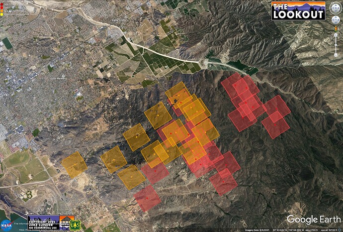
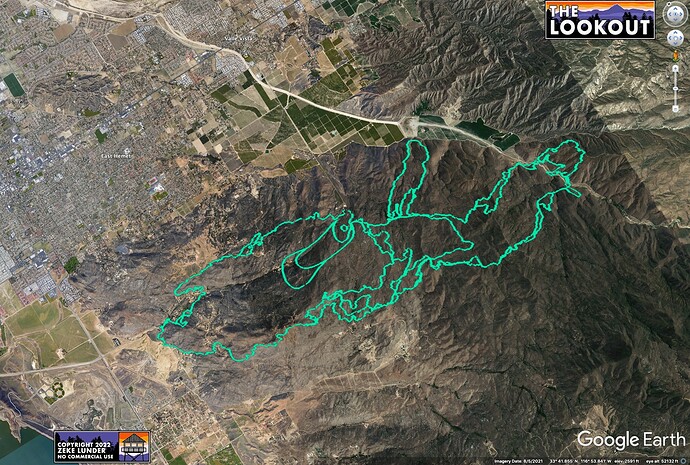
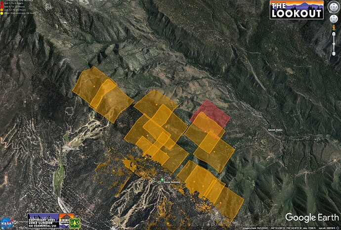
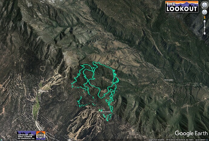
I think the maps tell the story pretty well. Here are two views of the Radley and Fairview Fires - both from publicly-available data captured this afternoon. The green line is FIRIS, which is the type of data some of us would like to see CAL FIRE releasing from their contract ships. The other maps are from MODIS, which is one of our only other options for automated fire data.
The media (including me) are going to publish maps of the fire using best available info.
Which imagery better serves the public? Do you think the Sheriff, animal rescue, inbound contractors, and evacuated public are better served by the images taken from deep space or the ones that are accurate within a few yards? What are the drawbacks of giving the public better data (that they are paying an arm and leg for, BTW)?
During McKinney Fire, the MODIS info was off by TENS OF THOUSANDS OF ACRES. People were panicking, and maps of this data were shared hundreds of thousands of times. Current MODIS of Radley Fire makes it look like the end of the world for Big Bear.


