I think they were asking for like road or neighborhood?
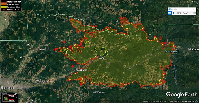
You could check this map. The red hot spots aren’t immediate, up to 12 hours old.
But the red perimeter should be pretty accurate.
Looks like the south, SE, NE, and north heat conglomerates are on logging land. I can’t find many residential that look threatened.
Is you were asking about structures surviving, the map is not necessarily an indication of loss just because the fire had come through.
Hope their property fared ok.
Sorry, 515 48th street, springfield is the address
Article about fire spread in industrial tree farms during this fire. http://eugeneweekly.com/2020/09/24/fanning-the-flames/
Mostly accurate. Not much of an Ingalsbee fan TBH, but mostly accurate.
Not a bad article from the Oregonian, discussing PNW East Wind events and recent fires.
Weyerhaeuser, SPI and the like are surely going to feel this financially. What are they going to do about it I wonder?
Hire more lobbyists.
They have incurred large losses. You, I and they know that lobbyists are not going to do anything about losses. How can they afford to have their main resource burn like this?
SPI has had fire on over 65,000 acres in California alone this year.
The costs get passed down the chain, wonder who is at the bottom 


Insurance Companies
Lol  !!! Its all of us who buy the insurance from the insurance companies for our homes and business!
Exactly!!!
We all pay to keep insurance profits intact, for sure. I’m pretty sure you can’t insure standing timber/plantations. Correct me if I’m wrong, though.
IDK but I do know ranchers can insure grass
I still say lobbyists are the best investment these companies can make in their future.
$27MM at the federal level does not sound like a lot of lobbying to me.


