It’s nice to have the dust temporarily suppressed on my dirt road driveway, but the duff still crackles underfoot in the woods. I sleep well even when I don’t rest easy. Prediction is hard, especially about the future.
3 Likes
I dont think its over. I think theres some complacency thinking it is because this season hasnt been the “normal” like youd typically see. Not many lightning busts, some shots of moisture, just enough to keep things mellow. Because of those factors everything thats started has been hit hard and fast because resources arent commited to multiple large fires within the state. Incident management teams and resources from all over california have been deployed to the northwest, and there was still never a draw down. I think that because its been slower than whats expected, id call it a lull, but not done. Still have a bit of the year left.
6 Likes
Hmmmm until we get any substantial moisture before a santa ana wind event or sundowner event its aint over. We will see what el nino brings.
10 Likes
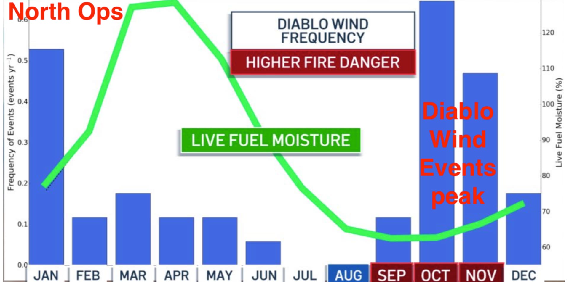
From Grok AI: Diablo events peak in October, right when live fuel moisture bottoms out. That overlap is why North Ops still treats October as the highest-danger month even in a strong El Niño year.
How a very large El Niño changes the Diablo picture
Diablo winds need a specific setup: high pressure over the Great Basin / Pacific Northwest plus a coastal trough. Strong El Niño typically works against that pattern. The jet drops south, more storms come down the West Coast, and the classic Great Basin high is less persistent. Research on Diablo climatology finds the opposite of this year’s setup is the dangerous one: La Niña years (especially with certain QBO phases) produce more frequent and drier Diablo events. El Niño years tend to produce fewer and somewhat weaker ones.
That does not mean zero Diablos. North Ops still lists offshore winds as the big wildcard west of the Crest, and their September–December outlook keeps a watch on October for “heightened potential at times” even while calling overall significant-fire potential normal after September.
Month-by-month for North Ops (including East Bay / Danville)
- Rest of September: Fuels are already near seasonal lows. Any early Diablo or gusty northeast event hits dry grass and cured brush. Outlook already has above-normal potential on the northeast and far eastside.
- October: Highest combined risk on the chart. Live fuel moisture is at its annual minimum and Diablo frequency is at its annual maximum. El Niño should reduce the number of events versus a La Niña year, but one solid multi-day Diablo while fuels are still critically dry is enough. This is the month to treat as classic fire weather.
- November–December: Two things start working in your favor. Live fuel moisture begins its slow climb (green line on the chart), and El Niño’s wetter, more active storm track is expected to kick in. That both raises fuel moisture and disrupts the high-pressure pattern that produces Diablos. Fire potential is forecast normal statewide by then.
Practical takeaway for the East Bay
Stay at full readiness through October. The El Niño is likely to cut the number of Diablo days and bring earlier wetting rains than a dry year would, but the calendar peak of those winds still lands on the driest fuels of the year. After the first couple of soaking systems in November, the combination of rising live-fuel moisture and fewer offshore events should drop the risk faster than usual.
2 Likes