I am not looking at the actual incident numbers every day like some of you are able to do - so cannot definitively know there is more activity for this time of year…
What I can say is - I cannot ever remember my emails blowing up with this many WORKING FIRES in April…I mean yes, occasionally one gets going at any time - but severl PER DAY worth an IA thread? Not that I remember…
I know I know - so what? But at least I put in the DISCUSSION thread - LOL!
It does seem early, but I don’t think its unprecedented. I think our visibility is quite a bit greater than in the pass. We didn’t use to have the ability to see the fires like we can now. I think this adds to our perception of the fires. None of the resource orders today were grand, or out of the norm. The crews running most of todays fires didn’t sound real stressed either. We have more resources to know that they are happening so we are more cognitive of them. I could be wrong though.
I would agree that we have a lot more awareness due to the cameras and SM, but if you look solely at the empirical data, this should be no surprise. The ERC, 100 and 1000 hour moisture levels are at record levels. We are trending at less than 50% of normal precip and on the heels of a dry year and only two years out of a 5 year drought. When you look at the ERC’s and FM levels, you see that the graphs show that we are at mid July levels, and the visible results are evident. Fires are growing and going beyond large spots- this would have been normal in mid to late June- when things were “Normal”…
I would expect that the acceleration will continue and we will see some fires going extended in May and June, with some major incidents coming in July…
Kind of scary when you consider the effects of a potentially increased monsoon season, could be a long summer for the Sierra’s…
The XSA operational area is declaring fire season on May 3. That will increase the 1st alarm to 2ea T1 engine, 1ea Wildland engine (T3 or T6) and a BC.
It’s safe to say the 1hr fuels in the area bone dry and browned out well over 2 weeks ago.
I can’t find the article now. But I read that due to high ocean surface temperature in the tropics and the same blob as last year it’s supposed to be increased. Yet was last year a more intense monsoon or did we just get our asses kicked by one giant multi day system?
Coastal lightning is often, if not almost always caused by tropical remnants. Without getting too much into it, the wave which causes the required lift may not be tropical, but if there is sub tropical moisture available, you will almost always get lightning.
Strong La Nina’s can cause a more intense monsoon, or even Atlantic Hurricane season. Some of it has to do with sea surface temps but also other factors, AO and PDO…
The joke in the SW has been there has been a “nonsoon” the last two years, hence the fire activity beyond July. We will have an idea by lat June, to early July where the Monsoon is.
Cooler SST off of California, could produce more onshore winds, and at least a strong marine layer near the coast. We will have to wait and see. What is for sure is the average outbreaks of lightning. If you march it out, we are overdue for an outbreak along the Sierra’s…
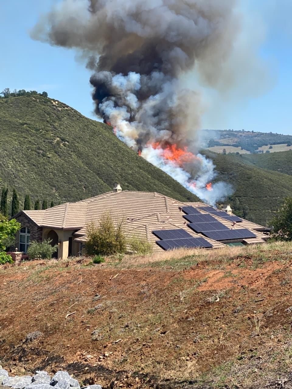
So, on the way too early thought process… Look at the smoke, brush contributing heat rather than absorbing it, fire making sustained runs in heavy brush fuel model, without much grass, more inline with late July than May 1…
Same thing with TCU-Campo fire made a run in the Brush Field. Interesting side note on about fifteen acres two weeks ago on a fire near Mountain Ranch TCU-Costa. Fire on the N to NE aspect burned clean and consumed 10 to 100 hr fuels. Dead snags, brush and ground litter etc. Grass was still green and had a hard time burning but the down and dead fuels consumed and with a little spotting going on… That just tells you how dry it is for this time of your.