New satellite warns of wildfire: GOES-17

This week NOAA was to officially throw the switch on the GOES-17 satellite, also known as GOES West. (GOES is an acronym for Geostationary Operational Environmental Satellite.) It’s been up and feeding back pictures in test mode since March.

The bird carries an imaging device that has triple the color range and four times the resolution of previous satellites scanning the western U.S. landscape.

Though it’s designed primarily as a weather satellite, it can also spot wildfires virtually as they’re starting.

It’s a “game-changer,” according to Paul Wloszek which built the on-board Advanced Baseline Imager.

“And it does all of this from geostationary orbit, which is 22,000 miles away,” Wloszek said. A geostationary satellite rotates in sync with the Earth, rather than making periodic “passes” over the planet. Essentially, it stays parked in the same spot, focused on the same area.

One thing all of this adds up to is the potential for much faster response when wildfires break out.

“Even 10 to 15 minutes before the first 911 call comes in,” says Wloszek, “first responders know that there’s a hotspot or a fire starting to happen.”

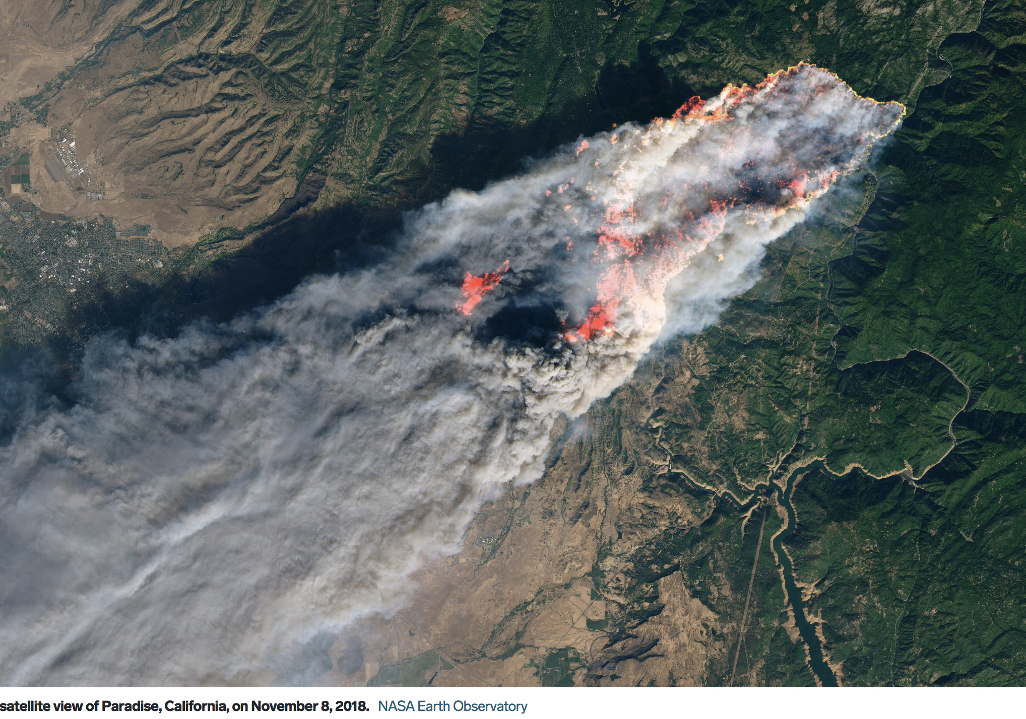
He says it’s not just theory; they’ve already seen it happen at a fire in Colorado, with images from its sister satellite, GOES East. Launched in 2017, it was the first to have the advanced imager. It captured distant images from the Camp Fire in Butte County, even from its position over the eastern half of the U.S.

Forecasters can also call up new views every 30 seconds, which is about as close to full-motion video as a satellite will deliver.

“It’s like you’re watching a movie from space of how it’s all evolving,” says Wloszek, "which really allows unprecedented situational awareness for first responders on the ground.

“What’s important about all that,” he said, "is not only can it detect it earlier, but because they can do 30-second updates, they can actually track the progression of the fire in real time."

The bird can even “take the temperature” of a growing fire, to determine where it’s burning the most intensely.

With it’s better image quality, GOES West will also offer advantages to weather forecasters; it can distinguish between clouds and smoke. The satellite is part of a “constellation” of orbiting eyes, which is set to get a new addition, GOES-T, in 2020.

This new satellite is the same resolution as GOES 16, which was operational for the 2018 season. It was useful for seeing how active the various fires were across the day, but it is still fairly low resolution - the fire and other infrared bands capture 2km pixels, so even if you have updates every 30 seconds, the pixels are still over a mile wide, and you don’t get any intel that is usable at a tactical scale.

Probably the most useful thing about the GOES imagery is if thre is enough heat happening to show up well on it, it tells you you have a real ass-kicker of a fire going. Also, it was interesting during the season to see some fires not doing much on it - one fire later in the season on the Shasta-T got a Type II team on it, but the GOES imagery wasn’t showing any heat, and it was a good clue they were going to have a big demob pretty quick. On a couple big fires you could see active burning through the night, so it let you know there was poor humidity recovery in that part of the world. So it is really useful information at a landscape scale.

The image shared in the post above is from LANDSAT, which has 30 meter resolution.
LANDSAT is great for seeing fires, but it only passes overhead every week or so, and we just happened to get lucky it was going over when the Camp Fire was taking off.

Here is imagery from GOES 16 of the Camp Fire.

1 Like

NWS has been using GOES 16 for hotspot notifications in the great plains with pretty good success, often spotting fires and notifying appropriate agencies before any prior reports come in. I would suspect it will prove even more valuable in some of the more rugged and remote areas of the west. If it can pinpoint a new start, early on, to within a KM or so, long before it’s putting up enough of a smoke column for a public report, that could be valuable. In the plains, a new start is usually going to be visible for several miles, and there’s probably someone within that distance…in the wilderness areas, it could be many miles to the nearest person looking, and having that earlier warning could be tremendous. Will be some bugs to work out, but great tool.

Related, one thing I learned in watching it is to be very cautious trying to interpret it to judge size of fire…some that didn’t look that large wound up being hundreds of acres or more, some that looked much, much larger wound up being a lot smaller. But, you know there’s a fire there, and can see that it’s growing in size or intensity, maybe both, and initiate an early response.

1 Like

From Wiki: GOES-17 can collect three times more data at four times image resolution, and scan the planet five times faster than previous probes.

GOES-17 has the same instruments and capabilities as GOES-16 (currently serving as GOES-East), and will complement its work by scanning a different area of the world. GOES-17 will become GOES-West and cover the west coast of the continental US. These two satellites are expected to monitor most of the Western Hemisphere and detect natural phenomena and hazards in almost real time.

Its capabilities will allow better:

  • fire track and intensity estimation
  • detection of low cloud/fog
  • tropical cyclone track and intensity forecasts
  • monitoring of smoke and dust
  • air quality warnings and alerts
  • transportation safety and aviation route planning
  • advanced monitoring of atmospheric river events that can cause flooding and mudslides

The article is conflicting: GOES 17 has four times image resolution of any previous satellite and then the article says GOES-17 has the same instruments and capabilities as GOES-16.

1.) What is the difference between the new GOES 17 and older GOES 16 satellites?

2.) What is a good link for an active GOES 17 site?

I found this: (http://rammb-slider.cira.colostate.edu/?sat=goes-17&z=0&im=30&ts=2&st=0&et=0&speed=130&motion=loop&map=1&lat=0&opacity[0]=1&hidden[0]=0&pause=0&slider=-1&hide_controls=0&mouse_draw=0&follow_feature=0&follow_hide=0&s=rammb-slider&sec=conus&p[0]=band_01&x=5000&y=5000)

I just went to one of the GOES 16 sites, https://weather.cod.edu/satrad/exper/ and it has a banner at the top that says GOES 17 imagery is in development, ETA Jan 2019. Of course that may be delayed, with the shutdown.

Were they ever able to solve the cooling problems with that satellite?

GOES 16 is also new - GOES 16 and 17 are the same generation.
The earlier GOES satellites (12-15) had 4km resolution on the IR bands.

Last I heard they would prioritize sensors based on time of day and/or need to help with cooling. So something like every other IR band at a time, instead of the whole bank of sensors etc. Or they would limit some sensors to longer timespans between use. I know on GOES16, and some of the 17 data I can get 5min intervals on the online portals I use. I wonder what the refresh really is for the higher priority users. The GOES17 data I have seen various sensors have gaps in their timeline. If you scrub across a 4 hour window you can see certain sensors giving 5/10 min intervals, then take a “nap” and then continue on 30min later or similar; clouds jumping ahead etc. Granted it’s still in experimental phase so we get what we get.

I just recall seeing the camp fire 5 minute intervals from ignition on various GOES16 sensors and from 22k miles out, it was insane just 20 minutes in.

Thank you for this explanation and information. It is really helpful to know what
goes can really do vs the hype.