Norcal, thank you for a very informative and detailed explanation of our wx in NOPS. For a guy who isn’t an IMET, you are pretty spot on. Sometimes the wx explanations can get pretty deep. Thanks for bringing it down to a level the typical fire service professional can understand. From my 2 cents, I think your posts do address the topic of this fire wx thread…
It’s a very positive thing that we still have power. Most people’s electricity bills are between $500-$1,000 dollars last billing cycle and the state is about to dish out $500 million in refunds… So my intuition is very much correct. Irregardless of causality/policy causing the high bills, the long duration and high levels of heat have made individual households and businesses electric bills almost unaffordable to the point of bankruptcy. We need to continue to manifest positive outcomes rather than doom.
I’m fairly certain it’s still summer and we’ll see a few more warm/hot days yet with with some ‘fire weather’. Won’t be long and Fall will settle in followed by cold rain and snow… Then come Spring/early summer we’ll start it all over again. It’s been that way for a ‘few’ hundred years now… Easy guys 

Because there’s going to be wind 15-25 mph in northeast Cali and northwest Nevada for a duration of 3-6 hrs on Monday.
https://forecast.weather.gov/showsigwx.php?warnzone=CAZ071&warncounty=CAC035&firewxzone=CAZ278&local_place1=15%20Miles%20E%20Eagle%20Lake%20CA&product1=Fire+Weather+Watch&lat=40.6184&lon=-120.4559
Funny how it happens year after year with a cycle. It always cracks me up how we report it likes it’s groundbreaking that we hit 100+ in the summer and it gets really windy in the fall. Then we have this deluge of water that ends it all.
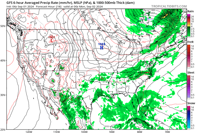
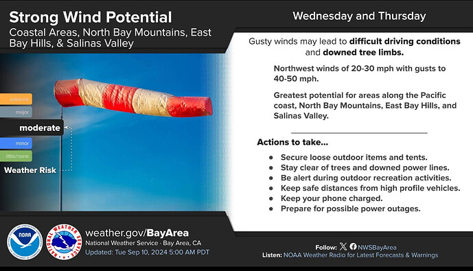
Forecast looks to remain on track for the early and mid week period. Cool down across NOPS today to average and below average temps. The area of LP will track north of Ca over Monday. This will take us across NOPS to below normal temps and an increase in RH. Winds crank up though… and will be gusty across the expected areas of the Bay Area, Central Valley and Shasta Valley and Modoc. East side will see some wind as well. That area has the potential for some strong down slope winds.
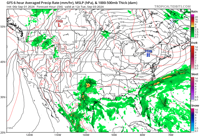
By Monday night the LP trough swings inland and moves east. This will usher in the first change, weak offshore flow will begin late Monday-Wednesday am. Peak looks to be Tuesday. This weak flow will bring warming temps and lowering RH. Temps bounce to above average for the middle of the week, with temps in the valley over 100 for much of Wed-Friday.
Some low RH will be likely. A thermal trough will establish and keep RH recoveries poor at night and overnight minimums in the Foothills will be on the mild side.
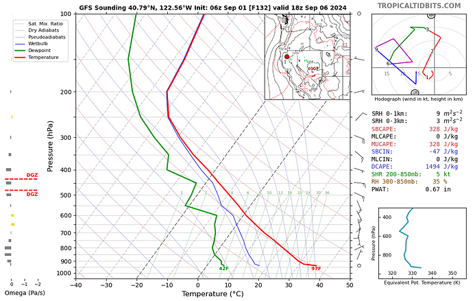
One new wrinkle in the models appeared this am… possible convective activity by the end of the week. This is shown on a couple of models… but I would still consider it fantasy land but more on the legit side of fantasy land.
As one of the IMET’s I respect always says in am briefings… “In fire weather it is the Delta( change) that we look for”.
This week and Fall in general is about the Delta. A lot of changing conditions through the next 7 days.
Yup… weather happens every day, every week and every year. The Chinese warrior Sun Tzu said famously…" if you know yourself and you know your enemy in 100 battle’s you will be victorious 100 times". The advances in meteorology allow us to cheat…we get to predict what type of fight we will be in.
Attached… 3 graphics. First gradients showing 4-6 mb onshore flow on Monday, then the reverse flow to offshore by Tuesday/Wednesday.
Last… sounding for some moisture by Friday. This shows the spread between the DP and temp. This is a single sounding but shows an inverted V profile which would indicate storms could be on the drier side. Steering level winds look to be moderate which could indicate faster storm motions. I would keep that in the "fantasy land " category. Perhaps someone with more formal education than I have can weigh in on that period.
Coming back from Wyoming last night about the Bear River Reservoir road on HWY 88 it was 67 Degrees at 0100. That’s around 6000 FT.
Fire season is still on for NOPS. Here’s the predictive services fresh seasonal outlook:
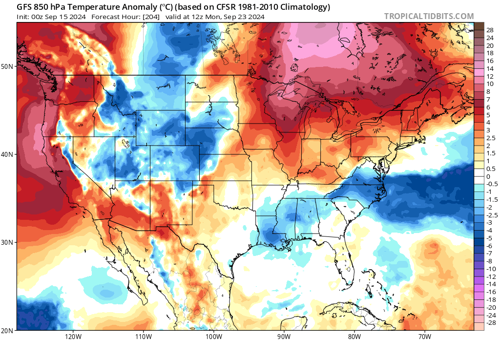
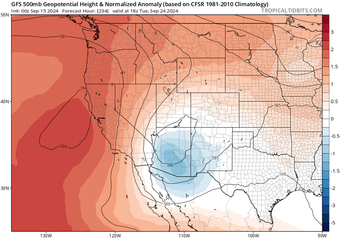
Forecast models are in very good agreement that a heatwave will impact California including Northern California starting next weekend. Surface high pressure building into the Great Basin in conjunction with a large height gradient from the amplified north pacific high pressure and an inside slider to the east will lead to downslope warming with light to moderate offshore Diablo winds. Significant drying of fuels is set to occur with fire weather related threats.
GFS demonstrated height gradient through normalized geopotential height anomalies
There are still model variations on how sharp this trough will be, which will dictate how strong offshore winds could get. The GFS is sharper than the ECMWF, and thus right now it should be expected that a solution occurs somewhere in the middle… with moderate offshore winds above 2000’ and VERY hot temperatures for this time of year.
CAZ015-016-066-160430-
Northern Sacramento Valley CA-
Northeast Foothills/Sacramento Valley CA-
Central Sacramento Valley CA-
834 PM PDT Sun Sep 15 2024
…STRONG THUNDERSTORMS WILL IMPACT CENTRAL TEHAMA…NORTHWESTERN
BUTTE…NORTHEASTERN GLENN AND SOUTH CENTRAL SHASTA COUNTIES THROUGH
930 PM PDT…
At 834 PM PDT, Doppler radar was tracking a cluster of strong
thunderstorms along a line extending from near Gerber-Las Flores to
near Richfield to 7 miles northwest of Orland. Movement was southeast
at 10 mph.
HAZARD…Pea size hail.
SOURCE…Radar indicated.
IMPACT…Minor hail damage to vegetation is possible.
Locations impacted include…
Red Bluff, Corning, Orland, Tehama, Gerber-Las Flores, Dairyville,
Richfield, Vina, Henleyville, Artois, Nord, Bluegum, Rancho Tehama
Reserve, Cottonwood, Los Molinos, Black Butte Summit, Black Butte
Dam, Hamilton City, and Black Butte Lake.
PRECAUTIONARY/PREPAREDNESS ACTIONS…
If outdoors, consider seeking shelter inside a building.
&&
LAT…LON 4042 12198 3980 12189 3950 12231 3977 12240
4007 12246 4040 12233
TIME…MOT…LOC 0334Z 316DEG 18KT 4011 12208 3995 12220 3982 12230
MAX HAIL SIZE…0.25 IN
MAX WIND GUST…<30 MPH
And this Flash Flood Warning for you know where…
https://www.facebook.com/photo/?fbid=932662415556758&set=a.246737254149281
Just me or does it really feel - dare i say it - “Fallish” this a.m? The nops got some wet stuff & there was no shortage of electricity in the sky either…
https://www.cnrfc.noaa.gov/precipMaps.php?group=nca&hour=24&synoptic=0
It’s one of the 2 or 3 short false falls we get every year
Temps warm back up by monday
