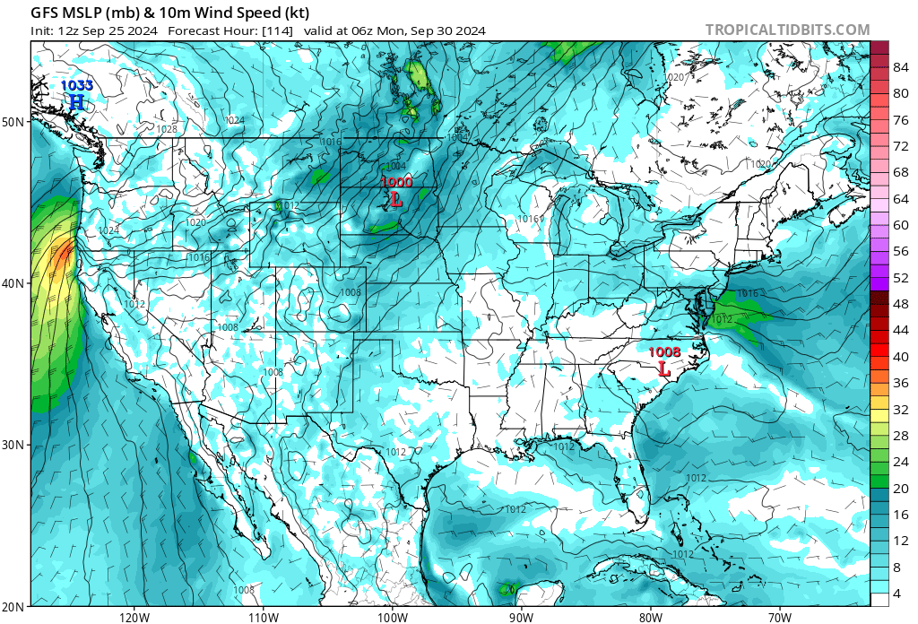
Warm and dry this week, some max temp records tied and broken yesterday. Ridge breaks down today and strong onshore flow returns through Friday before another ridge builds in.
We may see a repeat of the heat and low RH Sunday-Wednesday. Perhaps the first moderate strength offshore wind event. The HP will remain to the NW and not slide east rapidly into the GB. This should keep the winds on the moderate side and mostly restrict them to the area north of Sacramento.
Even with that fact some gusty winds will be possible at night and early in the am. The heating of the day and the normal diurnal pattern will limit north winds south of about Chico each day, but the winds will return at night. The winds will be more pronounced in the canyons especially the favored areas like the Pit, Feather and American.
Of note… Hurricane Helene looks to be a major Cat 3 storm as it makes landfall. The upper atmosphere is ripe for tropical development… not much shear to tear it apart. Right now the models have it moving north and then east across the SE and then moving offshore and gaining some circulation again but getting caught up in the jet stream and moving out off the east coast. The models do show another similar strength hurricane taking an almost identical path by late next week… tis the season.
Active hurricane seasons usually coincide with warm dry autumn’s in the west.
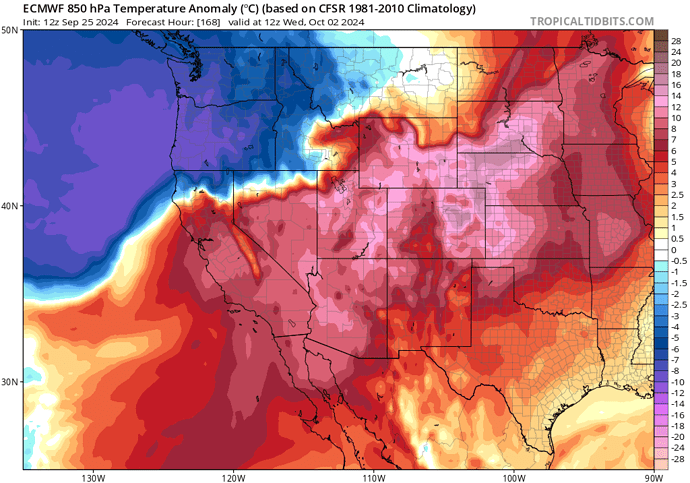
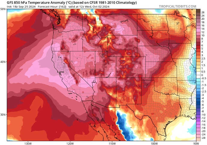
Forecast models are in very good agreement that a highly anomalous high pressure system with offshore winds will develop over all of California next week Saturday-Thursday with philosophical differences between the GFS and ECMWF. The 12z EC brings in a deeper trough and surface cold front over the Williamette Valley after highly anomalous ridging, the trough drives stronger offshore winds as it is further west with greater upper level support. Temperatures start off 8-15 degrees above normal. The GFS is further east with the surface cold front, and the ridge is directly overhead tilted with height towards the surface high pressure over the Great Basin. This causes the ridge to break down a lot slower and amplify more than the EC solution. The ridge drives the winds but temperatures are off the charts hot and heights/thicknesses would reach all time records for the dates. The most reasonable assertion is a solution somewhere in the middle occurs. This is because the GFS rushes troughs and cold airmasses and the ECMWF is likely playing into a bias of showing an early season trough a little far to the west. The sypnotic set up is only about 96 hours away and thus I would not expect the philosophy to change much, and heat advisories and red flag warnings will probably be necessary for this wind event.
Just a little note, if the GFS skew on this set up verifies it will probably push temperatures in the valley upwards to 110 degrees which is hot for any part of summer let alone fall, but you have the downslope wind component with RH values as low as 2% with that setup.
Use this only to supplement official forecast from the NWS and North Ops forecasters.*
ECMWF depiction of stronger surface high pressure building into the Great Basin (blue) as opposed to subsidence aloft
GFS depiction of extreme high pressure event and heatwave driven by stronger subsidence aloft vs at the surface. Forecaster note; the 18z is identical to the 12z and thus is being referenced
So in English this means
Is Big Ernie mad ?
Hot, dry, very windy or exceptionally hot, dry, and a little windy. Perhaps something in the middle?
Lol, now that’s a forecast. 
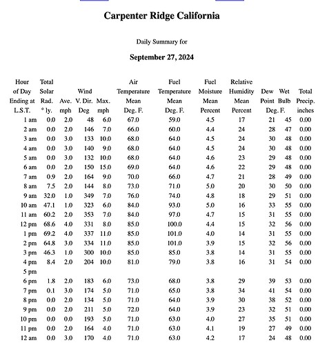
With all this warm/hot weather anyone taking Fuel Moistures up and down the state? It’s pretty freaking dry out in the woods right now.
for south ops - LA county:
Is it just me or is it looking like we tie or perhaps break the Oct 1st high temp record for RDD?
Seems very possible and the models can underscore compression aided heating during this time of year; so maybe can tag a couple degrees on whatever cross sections/NBM ends up showing.
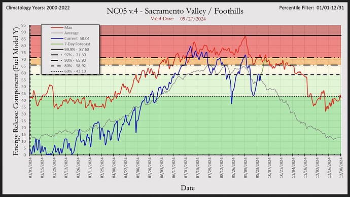
High risk day posted for Sac Valley/Foothills for Monday. Language from NWS Sac office suggests strengthening offshore wind component. The wind looks to remain below advisory level but will be gusty. The valley will really feel this on Monday. As stated and would be normal for this type of event the normal diurnal flow will return Tuesday and Wednesday but once the sun sets the offshore winds will return, mostly in the upper elevations and canyons. The most notable portion of this particular event will be the heat. We should see some records tied or broken in Nops for both Tmax and Tmin. The Tmin temps would be confined to the thermal belts on Monday and Tuesday. This along with the wind will allow for very low RH, we could see a few single digits especially on the west side of the valley.
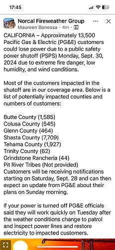
There does appear to be a PSP for much of NOPS.
Very dry in the North Sac Valley Foothills last few days, and less overnight humidity recovery than I would have thought. I slept out up by Chester on Thursday and there was no dew at all on my sleeping bag in the am.
Minimum RH never got above 24% overnight near Butte Meadows and the fuel sticks are LIGHT!
Interesting what @norcal74 is saying about breaking minimum temp records, too! Is that because we are getting cold continental air pushing in at night?
If this year has taught us anything, it’s respect the fuels and don’t underestimate how low the LFM has gotten. The part of the fuel equation that is the hardest to understand/extrapolate is the live to dead ratio with how much 1hr, 10hr, & 100hr.
The park fire showed us what can happen when sun baked vegetation catches fire and then wind, Slope & topography lines up.
Any benifits we got from any recent moisture will be long gone come Monday. It’s the trailing end of this upcoming heat wave that has me concerned. My gut tells me to compare it too what happened on the Carr Fire. Looking at the offshore SST(within 100) miles I can see a similar set up that once the High breaks down, the onshore winds could be record setting, with low RH and extreme temperatures still in place.
Somewhat of a different mechanism in place when compared to the situation with the Carr and other summer HP cells. In those the breakdown of the ridge is often driven more by a “baggy trough” pattern where the High drifts south or east allowing the onshore flow to establish and persist.
The Carr Fire had more in common with the Rattlesnake Fire in the Grindstone drainage. Strong HP with a thermal trough in place in the valley. The Thermal trough is an area of lower pressure allowing air to sink. As HP squeezes down the warm air rising in the valley pulls cool air in to replace it. As the cold air from the coast builds up on the west side of the coastal gaps from the air rushing in to replace the warm air rising in the valley, it is sucked through the gaps. In the case of the Carr Fire it is called the Arbuckle Basin.
A thermal trough can have the same effect, warm air rising and cool air replacing it, means that you have persistent downsloping wind effect, so a dry Katabatic process is in place. This will explain why fires can move down slope and down canyon… when it would appear that they should only be affected by a down canyon wind.
If you watch the Chetco river it routinely has a TT that forms and helps keep temps along the coast in Brookings at 85-90 F while just 20 miles away Tmax are only in the 60’s.
In this particular set up we will be under a transient HP ridge to the north( summer like) but it will move out quickly and be replaced by a weak LP system( for now) and then another HP cell( very Fall like… progressive).
For now the models want to bring s short window of onshore flow and then another ridge builds in with some additional offshore winds. The other difference for us(NOPS) this time of year is that when HP breaks down our temps cool and RH rises quickly.
I agree… FM’s are in the tank and even a modest wind event will drive a fire. The temps this week will be remarkable, especially in the valley where could see a 45 degree temp swing in a 24 hour period. If we do get a strong onshore push it will take 48 hours for the fuels to catch up( time lag).
