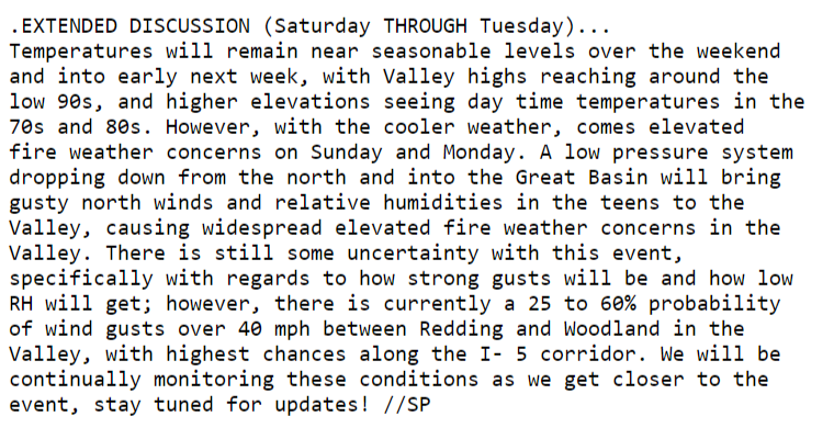
Forecast models are in agreement that a moderate strength Diablo wind event could occur next weekend. Run to run consistency with some ensemble support points towards the wind event occurring. A cold upper level trough moving into the Pacific NW is forecasted to absorb a cut off low off of the coast of Southern California. As this occurs, the trough sharpens enough over the Great Basin to initiate an offshore wind event. A dry airmass advected into the region coupled with the longest days of the year could bring the threat of elevated or critical fire weather conditions in receptive fuels.
21 Likes
High pressure builds into the territory today resulting in above normal temperatures across the far interior and near normal temperatures elsewhere. The ridge of high pressure peaks in strength tomorrow leading to temperatures rising into the triple digits across the interior and low to mid 90s throughout coastal valleys. High pressure then weakens during the latter half of the week as a broad area of low pressure begins to move onshore. As a result, temperatures should decrease back to near normal by the end of the week and over the weekend. Periods of breezy northwest or northerly winds will also be possible along the coast and across the northern interior Friday through Sunday. Daily afternoon chances of showers or isolated thunderstorms will continue through Thursday across the high Sierra before dry weather returns late in the week through Sunday.
7 Likes
2 Likes
Here’s a fresh video from Daniel Swain with his perspective of the seasonal outlook. He’s a little more pessimistic than Predictive Services. He’s always interesting to listen to and learn from.

5 Likes
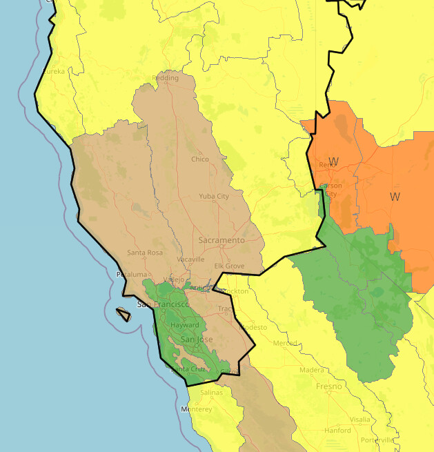
7 day fire potential: Westerly winds will increase today through Fri & continue into Sat ahead of fairly strong trough. These winds combined w/low RH will lead to an enhanced fire spread risk Fri into Sat in areas w/cured vegetation.
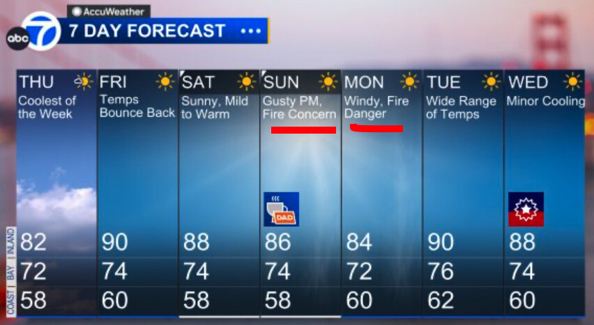
SF ABC 7 image:
5 Likes
-
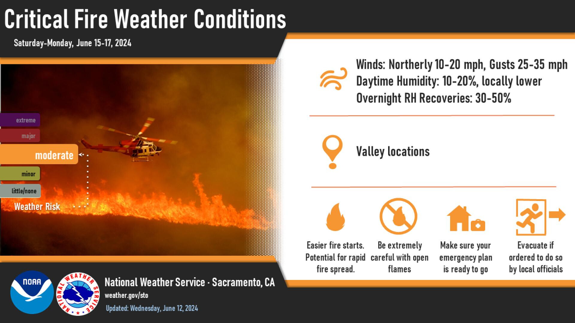
Low pressure trough aloft influence will move into N Ops today & deepen w/a secondary low pressure trough Sun-Mon leading to enhanced & gusty westerly & northerly winds & low RH. This will lead to an enhanced fire spread risk in areas w/cured vegetation.
-
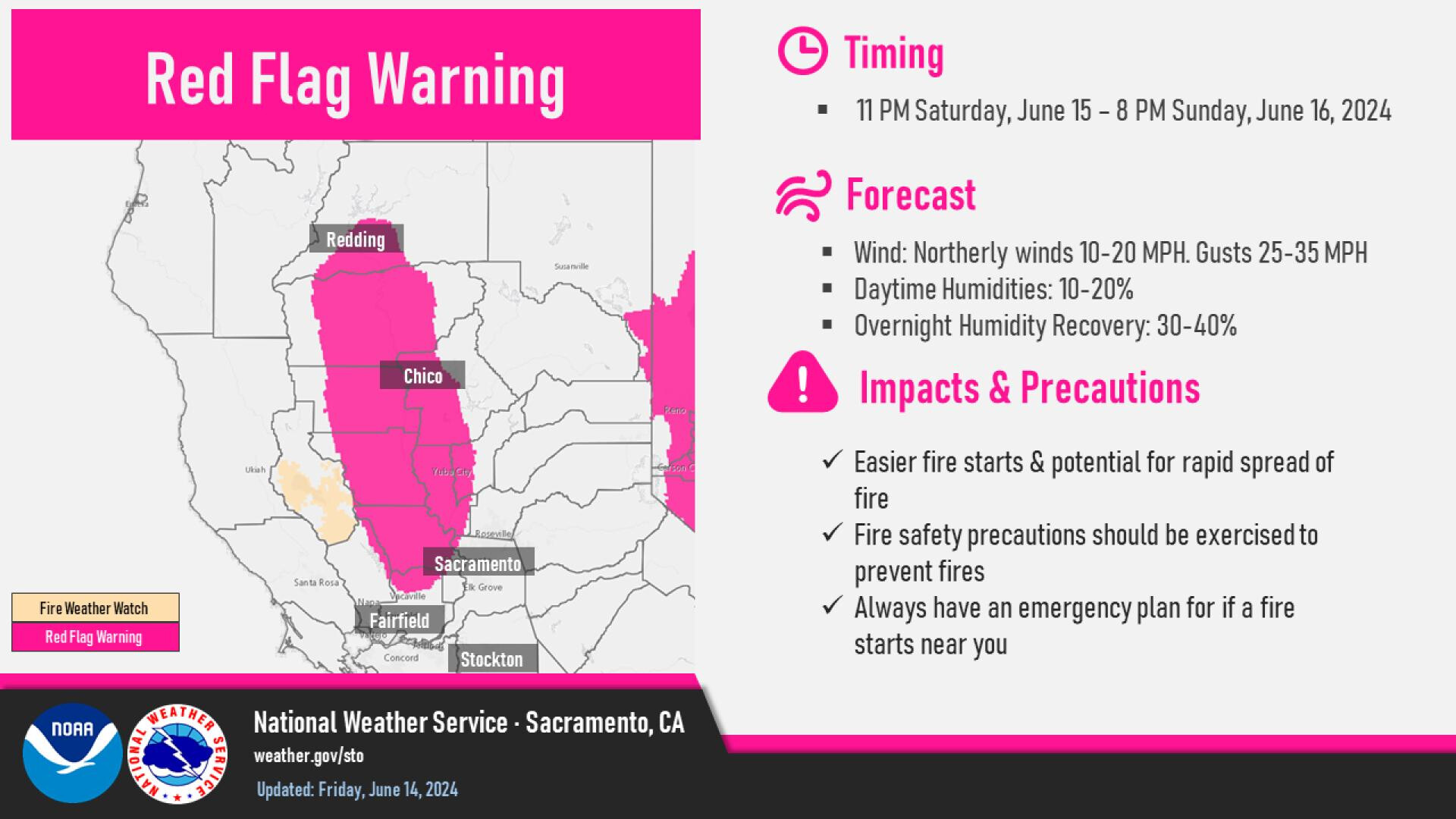
Expect Min RHs 10-30% w/gusts 25-45mph, strongest this evening to overnight w/continued low RHs.
-
Winds become northerly Sat night-Sun w/low RH continuing across many inland valley areas before turning more westerly again due deepening trough moving through N Ops. Expect near critical conditions to continue thru Mon due to NW winds & low RH Mid Coast Mendo, Diablo Santa Cruz, & Sac Valley/Foothills PSAs.
5 Likes
4 Likes
4 Likes
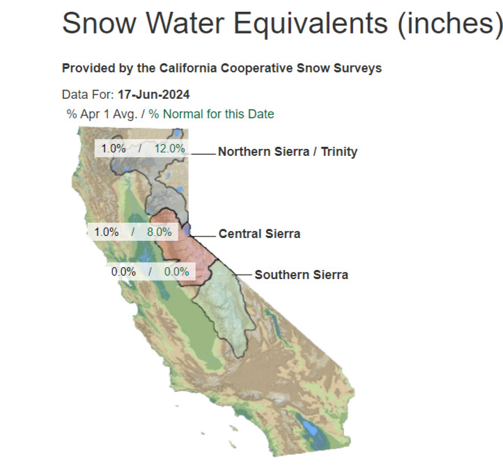
Things are not going well for the state of CA this summer and now that the excess moisture from back to back rainy seasons has cooked off I would expect to see a runaway heatwave that threatens the power grid in late August into September.
9 Likes
Assume the rest of us aren’t as smart as you and explain that last post. Does it mean that because the ground will be dry the atmosphere will be and that’ll add to the likelihood of heat?
6 Likes
Reduced cooling via melting and evaporation, and reduction of reflectivity with dirt taking the sunshine, instead of snow cover.
3 Likes
I echo Twigpig’s question, is that referring to the lack of water in the ground and air no longer moderating the daily temperature?
1 Like
Reading this and the pending heat wave makes me think some long duration winds will be blowing.
1 Like
Yes, the lack of snow cover and moisture in the higher terrain leads to less low level moisture potential for the monsoon. So the boundary layer can warm up a little faster now due to the lack of moisture. This is bad because of all of the subsidence we are experiencing due to the dynamic La Nina/enhanced North Pacific jet stream due to the pool of warm water over the North Pacific.
My concern for the state of CA transcends purely just one fire season though, and watching a sequence of meteorological events take place lends credence to that threat. So it becomes logical and easier for me to understand what may occur next. It’s basically alchemy but in a way that is bad. For all of the people who say worst fire season ever, every single year… well this is probably the year.
12 Likes
Since we’re talking about un-nice fire season’s. Seems like a brief tactical time-out for this may be in order… fires give the lesson.pdf (50.9 KB)
6 Likes
The Blue Card guy adapted for Red Card folks.
2 Likes
4 Likes