From NWCG :
*** High Risk for N to NE Winds & Very Low RHs in the Sac Vly/Foothills Mon Night through Wed and Mid Coast Mendocino late Mon Night & Tue with Moderate Risk for Isolated Dry Lightning in the NE Today ***• Troughing over North Ops today will move east as a strong & very dry upper level ridge will build along the coast Mon & Tue then shift inland and remain centered overhead for the remainder of the week.
• Isolated to widely scattered mixed wet & dry thunderstorms this afternoon & evening with strong outflow winds. The most likely area of thunderstorms development is the Mt Lassen convergence zone vicinity including Lassen, Plumas and Washoe Counties with isolated storms also possible in Modoc County and a very slight chance extending into the NW Mtns as well.
• Breezy W-SW to NW winds of 20-30 mph will develop this afternoon & evening favoring coastal gaps and eastern areas with inland Min RHs generally in the teens, 20s, 30s & 40s. Locally breezy N to NE winds of 15-25 mph will develop the Sac Vly and channeled terrain areas along the Cascade/Sierra west slopes tonight and continuing into Mon morning. RH recoveries will be good NW & NE though will remain moderate to locally poor along central & southern slopes & ridges.
• Temps will warm rapidly through the week with Heat Wave conditions from Tue-Sat, widespread poor to very poor overnight RH recoveries and strong thermal belt impacts keeping nighttime temps unusually warm as well.
• NW winds of 20-30 mph will favor western and northern areas Mon afternoon & evening then turn N to NE Mon night locally gusting 25-40 mph and spread south through the Sac Vly and along the Cascade/Sierra west slopes through Tue morning accompanied by rapid drying.
• Gusty northerly winds will continue Tue with RHs dropping to 5-15% across much of North Ops including near coastal areas and continuing to be quite low through much of the rest of the week.
• Breezy NE winds with minimal RH recoveries will return for Tue night through Wed morning with lighter general N to NW winds during the following afternoons, shallow W-SW coastal gap winds in the Greater Bay Area vicinity and more limited N to NE winds through channeled terrain areas during the following nights.
Scary deal with high heat, low RH and gusty winds…


Big dip in RH in Vacaville. 34% down to 11%… North winds coming up now.
I was up in Tahoe over the weekend and got a chance to collect some green vegetation samples at 6,000’, 5,000’, 4,000’, 3,000’, and 1,000’ elevations along Highway 20 on the way home.
I used them this morning for a Lookout wildfire education video this morning about live fuel moisture.
Cliffs Notes: Brush above 3,000’ is pretty much in its peak growing phase right now, has a lot of moisture in it, still. Fires in these areas with a lot of green brush and not a lot of dead fuel (e.g. recent burn scars) will not likely carry very well once they fall out of alignment or run out of slope.
I’ll weigh the samples and dry them to get the actual moisture values for another video - this one is more down and dirty…
https://youtube.com/live/YrRfS6So5EY #firescience
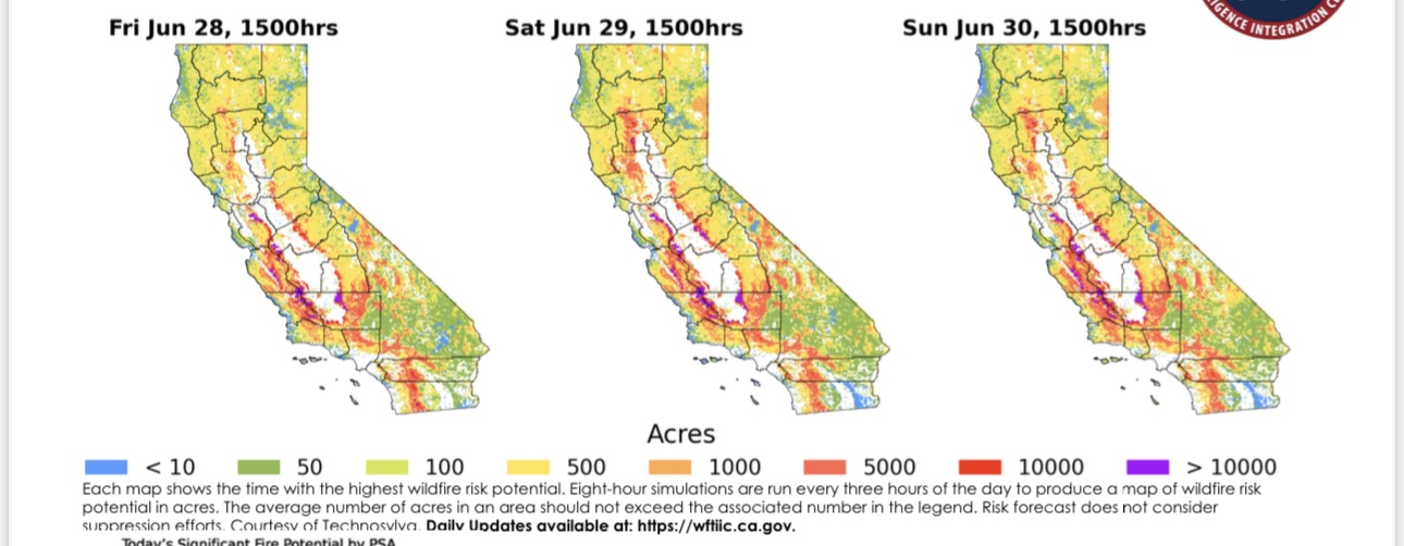
I thought this graphic gave a pretty good representation of what you found with your fuel moisture. The “red predicted acres” is slowly but surly creeping up into the timber I remember years passed we were into the purple already.
2300 at my house in Vacaville, Ca 83 degrees RH 17% Wind NNE @ 17. Not much sign of any Humidity recovery here.
Wednesday morning & -3 0600 WX. 81 degrees here, RH 18% Winds ? Variable @ 5 mph.
Forecast for 111 today with 8% RH. Stil basd fire weather outlook.
From NWCG :
*** High Risk for N-NW-NE Winds & Very Low RHs across the Sac Vly/Foothills, Mid Coast Mendocino and Diablo SC Mtns Today and Tonight****** High Risk For Very Hot Temperatures and Very Low RH across Mid Coast Mendocino, Bay Area Marine, Diablo SC Mtns and Sac Vly/Foothills Thu through Fri ***• Strong high pressure building aloftis promoting gusty N-NW-NE winds today along with very hot temperatures and critically low day and nightime relative humidity across most areas. The winds diminish by Thursday but the heat wave influences will continue into the weekend.
• Gusty N-NW winds of 25-35 with higher gusts to 45 mph this morning across the Sac Vly, Western slopes and Coastal Gaps. Winds diminish some in the afternoon but return again late tonight and early Thu with a slight decrease in wind speeds. Critically poor RH recoveries will accompany the nightime/morning winds.
• GustyNE-E winds of 20 to 30 mph with gusts to 40 mph this morning will diminish and become more westerly this afternoon across the lower slopes of the Sierra/Cascade and along the NW corner coastal hills. These winds return again late tonight and persist through the early morning hours with a slight decrease in speeds compared to this morning. Critically poor RH recoveries will accompany the nightime/morning winds.
• An extremely dry airmass will combine with the heat wave and lead to minimum daytime RH values of 10 to 25% across all areas including the coast through the weekend. Many inland locations will likely see single digits. Little to no RH recovery is expected for all areas east of the immediate coast. Coastal areas will only see recoveries of 45-60%.
• Very hot daytime temperatures in the upper 80s to mid 90s along with unseasonably low RH of 25-40% is expected along the immediate coast and coastal interior regions through the weekend before some marine influence may return on Mon.
• Interior valleyswill see widespread temperatures in the 105-118 range through the weekend. Both coastal and interior upper slopes and ridges will also see very warm and dry nights as thermal belts become established.
• Theridge of high pressure will begin to shift eastward early next week promoting a return of weak onshore flow and enhancing marine influence to the coastal areas with cooler temperatures and higher RH values.
• Thunderstorm potential looks to return on Sat and persist through Tue along the N mtns, Sierra and NE mtns…with a slight chance possible over the NW mtns.
-Heat Wave characteristics (enhanced thermal belts, compressed Marine Layer, longer burn periods), heightened Burning Index (BI) values in the 80th to 90th percentile and the 90th to 97th percentile or above in several PSAs, and a holiday week that typically has lots of ignitions further increasing the likelihood of significant fires.
• High Risk has been designated for gusty winds and very low RHs for the Sac Vly/Foothills, Mid Coast Mendocino and Diablo SC Mtns PSAs and continues through late tonight.
• Winds begin to diminish on Thu but High Risk for Hot/Dry conditions was added to the near coast PSA’s and Sac Valley as those areas may see record breaking temperatures with little to no marine influence through Fri.
• The N Ops snowpack lies above 8000 ft in the fully sheltered or highest peak areas.
• Dead Fuels will remain unseasonably flammable across most portions of the region during the near term with an increasing critically flammable fuel bed next week. Most PSAs will experience +80th percentile ERCs the next several days, away from the coastal influences, while +90th & +97th percentiles should occur as next week progresses across many of the PSAs.
• Herbaceous grasses & forbs are generally mostly cured below 3000-4000 ft while in various stages of green-up above 5500 ft with the exception of cheat grass which is curing as high as around 7000 ft. Fuel loading is generally above to well above normal with lots of continuous/dense grasses.
• Live Woody Brush-Shrubs & Tree Canopies are generally curing across the low & mid elevations while moistening across the higher elevations. Shrub fuels are becoming less resistant to fire spread across the lower elevations and some mid elevations that are more exposed to the sun. The upcoming Heat Wave event could flip the switch in terms of flammability in the live woody fuels across the lower and some mid elevations…
From NICC :
*** High Risk for Heat & Dryness across Mid Coast to Mendocino, Bay Area Marine, Diablo-Santa Cruz Mtns and Sac Vly/Foothills PSAs Today thru Sat excluding Bay Marine PSA Sat ***
- Strong high pressure centered W of coast will strengthen today & move over N Ops Sat bringing very hot, likely record breaking, temperatures and critically low day and nighttime RH across most areas today thru this weekend w/temps peaking most areas Sat.
- Breezy northerly & easterly winds across N ridges, gaps, & passes this morning w/poor RH recoveries weaken this morning w/generally light terrain driven winds this afternoon-evening. Surge of breezy westerlies comes into the W Sac Valley this evening.
- Breezy to locally windy westerlies this morning w/mdt-poor RHs east bay area, Sac River Delta area, & Mt Diablo to Santa Cruz Mtns will increase this afternoon-evening w/gusts 20-40mph along w/low RHs 15-30%.
- Westerly flow coming in from the coast each afternoon to evening will gradually strengthen w/each day thru the weekend & then persist early next week. Winds likely to become increasingly more S of W w/time as upper level pattern shifts to high pressure centered SE of N Ops.
- An extremely dry air mass will combine with the heat wave and lead to minimum daytime RH values of 10 to 25% across all areas including the coast through the weekend. Many inland locations will likely see single digits. Little to no RH recovery is expected for all areas E of the lower elevations of the coast.
- Interior valleys will see widespread temperatures in the 105-120 range through the weekend. Both coastal and interior upper slopes and ridges will also see very warm and dry nights as thermal belts become established.
- Increasing onshore flow early next week will enhance marine influence for coastal areas bringing cooler temperatures and higher RH.
- Ridge center shifting E of N Ops Sat afternoon results in southerly flow aloft Sat PM thru next week. This will open the door for potential T-storms, though atmosphere likely to be too dry initially. Current potential looks to be very slight (10%) across mtns NW-N-E of the Sac Valley this weekend into early next week increasing later next week across Sierras to Lassen NP to Warner Mtns.
With minimal winds in the North Ops area and seeming to maintain under 20mph would it be safe to say fire spread will not be drastic even with starts due to not much wind influence
You still have fuels and topography much of our grass crop in the foothills would normally be FM1 (short grass) this year with the rains many areas are FM3 this means more intensity and longer residence time. Also with the late season snow we had there are tons of dead and down trees and branches again more BTUs more resistant to control. Any fire that starts at the base of a slope is going to take off. Then depending on mixing heights (instability) if the fire generates enough energy it could go plume dominated and wind won’t matter
Updated forecast for Delta and the Diablo Range, which covers a large portion of NOPS, is stating winds this afternoon at 20 gusting to 40. So I have a hard time agreeing with Fyre’s comment. In all fuel types, but especially grass, a 20 mile an hour wind will outrun you and your equipment quickly. We just burned 10 acres mostly pushing downhill, with the wind, in grass in about 20 minutes. Where the fire pushed uphill, flames lengths were in excess of 10 feet.