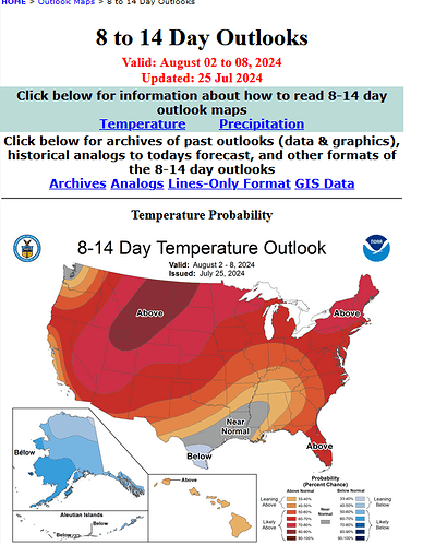
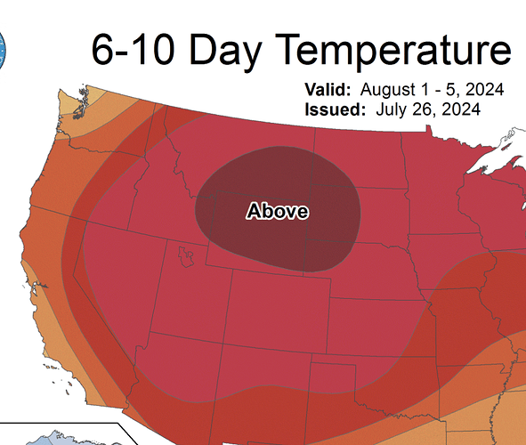
Those extended Outlooks can change almost daily. The NWS is still calling for a cool down with much cooler nights beginning Friday night thru at least Tuesday. Beyond Tuesday yes the forecast shows a another warming trend. Even just a few days relief would be a blessing for all.
Summer says hold my beer lol let’s turn the heat up
I"m aware of this and that’s why I use them purely as guidance. But this comes on the heels of Daniel Swain and Anvilhead stating yesterday that August is not going to be pretty when it comes to temps
If I’m not mistaken, Anvilhead stated 2+ weeks ago that he was expecting August to be considerably hotter than July. Just sayin. This “cool down” may be a good time to grab another Gatorade and put some more oil on the boots.
Dr. Swain feels the same way…could be ugly !!
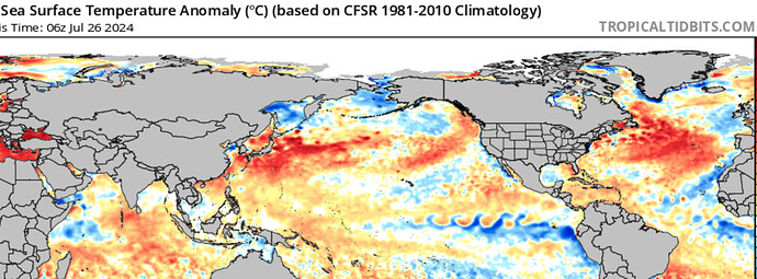
Unhinged August is set to kick off with an additional heat wave/drying cycle. The ridge is directly overhead around the 1st of August so the only chances of thunderstorms will likely be from troughing around the ridge offshore, eroding the ridge a bit. This will increase chances for more lightning especially into Oregon and Washington. To make things worse, a very warm kelvin wave of water is now landfalling on the US west coast. This is occurring at the same time that easterly flow ‘trade winds’ are at their highest so sea surface temperatures are trending much much above normal even after upwelling in front of the kelvin waves movement. This makes the baseline low temperatures warmer.
I am hopeful that relief may come around August 11th as the tropical trough may make its way into Southern California in the form of a tropical cyclone or remnant low bringing a big moisture surge. Tropical cyclone development should be monitored as well as the increasing SST due to highly anomalous heights and trade winds over Baja. The caveat is that a tropical cyclone moving north could amplify the high pressure system & bring wind. August is going to likely be a crazy month for the world weather wise and the rest of this year will be some sort of spiritual journey…
Difficult to put dates to temporal markers.
When atmospheric & marine heat wave’s collide… Sounds like a soap opera bcuz is one!
Sea surface temps: Ocean Analysis | Tropical Tidbits
Japan looks like it must be a hot springs resort. I’d be interested in seeing what a high waters temp map might have looked like back a few decades.
55 degrees in Vacaville now. RH 55%. Winds SW @ 6. Huge but welcomed difference. BUT more hot coming.
FYI guys I’m not claiming there’s going to be a tropical cyclone in California around 8/11, just that the monsoon trough could get far enough north to bring us relief in the form of increasing moisture, clouds etc. it often comes in the form of TC remnants and lately actual named storms. common sense + climatology
From NWCG~
Cooler upper level troughing will persist over North Ops through Tue with strong ridging building in Wed-Fri and bringing a return to hot & dry conditions which may be followed by thunderstorm activity next weekend.
-
Locally breezy W-SW winds of 15-25 mph range will develop through coastal gaps and from the Cascade/Sierra crest eastward this afternoon and evening with S-SE winds of 10-15 mph through the Sac Vly.
-
RHs in western areas will remain moderated due to the marine layer along the coast though will dry slightly in comparison to yesterday across inland areas with afternoon Min RHs in the teens, 20s & 30s and largely dependent on smoke density as to which areas will see the driest conditions.
-
A dry trough passage on Mon will breezier S-SE to W-SW winds in the 20-30 mph range Mon afternoon & evening with a gradual drying trend in RHs continuing and similar though slightly less widespread breezy pattern on Tue.
-
Temps will remain slightly below seasonal averages through Tue then warm quickly to above normal Wed & Thu and well above normal Fri & Sat with winds diminishing mid to late week aside from typical summertime afternoon & evening local breeziness out of the SW to NW through coastal gaps and from the Cascade/Sierra crest eastward.
-
Afternoon Min RHs will return to the upper single digits, teens and 20s away from the coast mid to late week with poor overnight RH recoveries returning to slopes and ridges as thermal belts strengthen again.
-
Mid level moisture and instability moving up from the south late week will bring thunderstorm chances on Sat & Sun. The potential coverage, location and timing of the thunderstorm activity still remains uncertain but is likely to be problematic as it will be occurring during a time period with well above normal temps following another hot and dry spell.
From NWCG~
***** High Risk for Lightning Fri Night Thru Sat Across NW-N-E Mtn Areas *****
-
Cooler, more stable conditions today & Wed will transition to Heat Wave conditions Thu into next week w/isolated to widely scattered thunderstorms likely Friday night thru Sat across mainly mountain areas.
-
Good RH recoveries across many western & central areas this morning w/mostly mdt recoveries elsewhere, except poor in the Sierras. RHs will remain relatively higher & temperatures lower & near normal today w/lesser afternoon-evening breezes in & around the bay area, Sac River Delta area, & N-NE of the Cascades & Sierras.
-
Poor RH recoveries tonight into early Wed w/slight easterly breezes along the eastern Sac Valley Foothills, but building high pressure Wed will result in lighter winds while Min RHs fall into the teens.
-
Temps will remain near to below seasonal averages today then warm quickly to above normal Wed & Thu, then to well above normal Fri-Sun with afternoon Min RHs returning to the upper single digits, teens, and 20s away from the coast mid-late week w/poor overnight-morning RH recoveries returning to slopes and ridges as thermal belts strengthen. Highs in the inland lower valleys likely 100-110 Wed thru early next week w/lows around 70F.
-
Mid level Monsoon moisture & instability moving in from the SE late week is likely to bring mixed wet & dry T-storms favoring the NW-N-E Mtns with the highest confidence in storm activity currently focused on Fri night thru Sat time frame. A chc of T-storms lingers in the NW Mtns for Sunday, but confidence lower.
-
Additional concerns include the potential for enhanced column development along the leading edge of the mid level moisture Fri as well as the lower confidence potential for thunderstorm activity in other locations during the Fri-Sun period, esp the potential of more isolated drier thunderstorm chances along the Mendocino Mtns Frti night- Sat.
-
Heat wave is likely to continue through much of next week w/T-storm chances most likely remaining S, but confidence in the forecast details beyond day 5 is low due to subtropical influences.
Fair and dry weather with slightly warmer temperatures is expected today as high pressure builds into the territory from the Desert Southwest. Temperatures will continue to gradually trend upward each day with temperatures reaching around 5-10 degrees above normal. By the weekend and early next week, triple digit heat is expected across the interior with daytime temperatures in the 100-110F range, 80s and 90s across coastal valleys, and more seasonable temperatures in the 60s and 70s near the coast. Monsoonal moisture is also expected to move into the territory from the south on Friday and Saturday leading to a slight chance for thunderstorms across the Central Valley, interior Bay Area, and northern mountains on Friday and Saturday and increased chances for afternoon thunderstorms across the Sierra through the weekend. Hot and dry weather is expected to continue across the interior through early next week with more seasonable temperatures near the coast and continued chances for thunderstorms across the high Sierra each afternoon. Fuels: The grass crop has fully cured across the lower elevations and dead fuel moisture values have dropped significantly below normal levels due to recent extreme heat. The moisture content in live fuels is still somewhat elevated in the higher terrain but has decreased well into flammable levels across the lower elevations


