State ID: NV
3 letter designator: HTF
Fire name: Slink
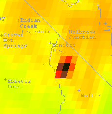
Location: 38 34.068, -119 34.074 (Slinkard Valley)
Reported acres: 150
Rate of spread:
Report on Conditions: Sage and grass
Structure threat:
Resources: B323 B3335 B3665 B621 BC 14 BC 21 BC 3904 OV B3141 PTL 723
Hazards:
Weather:
Radio channels:
Scanner link:
Webcam link: http://www.alertwildfire.org/blmnv/index.html?camera=Axis-BaldNV&v=518dd6b
Agency Website:
2 Likes
Is this in CA? Looks like west of Walker.
It is in California. Slinkard Valley is west of Topaz Lake. Not as far south as Walker. Steep country. There have been 3 or 4 large fires in there in the last 20 years. They tend to be driven north by the wind and come down toward Holbrook Junction.
1 Like
The fire is in California, but the unit id is NV-HTF. The Humboldt-Toiyabe NF extends to that chunk of California. That also makes that area part of FS R4 instead of R5.
2 Likes
Reported up to 1000 acres this morning. Yes, its in CA but on the HTF. Others know the exact GACC boundaries better but pretty sure this is that rare section of CA in the Great Basin GACC.
6 Likes
That is correct.
4 Likes
Heat signatures are showing it pushing mainly east, and estimated acreage closer to 7,000.
1 Like
Spot Forecast for Slink…USFS
National Weather Service Reno NV
219 AM PDT Sun Aug 30 2020
Forecast is based on forecast start time of 0000 PDT on August 30.
If conditions become unrepresentative…contact the National
Weather Service in Reno.
.DISCUSSION…
Drier and more stable conditions today. A dry cold front will usher
in steady north winds Monday afternoon with very dry air moving into
the eastern Sierra Tuesday through Thursday with temperatures climbing
to well above normal. Buildups and an isolated thunderstorm is possible
next weekend.
.TODAY…
Sky/Weather…Sunny. Haze.
Temperature…Max 82.
RH…Min 14%.
20-Foot Winds…Upslope 4 to 8 mph, then becoming north
to northeast 9-14 mph by afternoon.
LAL…1.
Chc Wetting Rain…0%.
Mixing Height…200-500 ft agl then 8900-9900 ft agl in the
late morning and afternoon.
Transport Winds…Light winds.
Ventilation…Poor in the morning increasing to good by
afternoon.
Haines Index…5-6.
.TONIGHT…
Sky/Weather…Clear. Haze in the evening.
Temperature…Min 50-55.
RH…Max 55% except 35% midslopes.
20-Foot Winds…Northwest winds 9-14 mph becoming downslope
2-6 mph by midnight.
LAL…1.
Chc Wetting Rain…0%.
Mixing Height…5000-6000 ft agl in the early evening decreasing
to 200-500 ft agl in the late evening and
overnight.
Transport Winds…Northwest 10 mph in the evening becoming light.
Ventilation…Good in the early evening then becoming poor.
Haines Index…4-5.
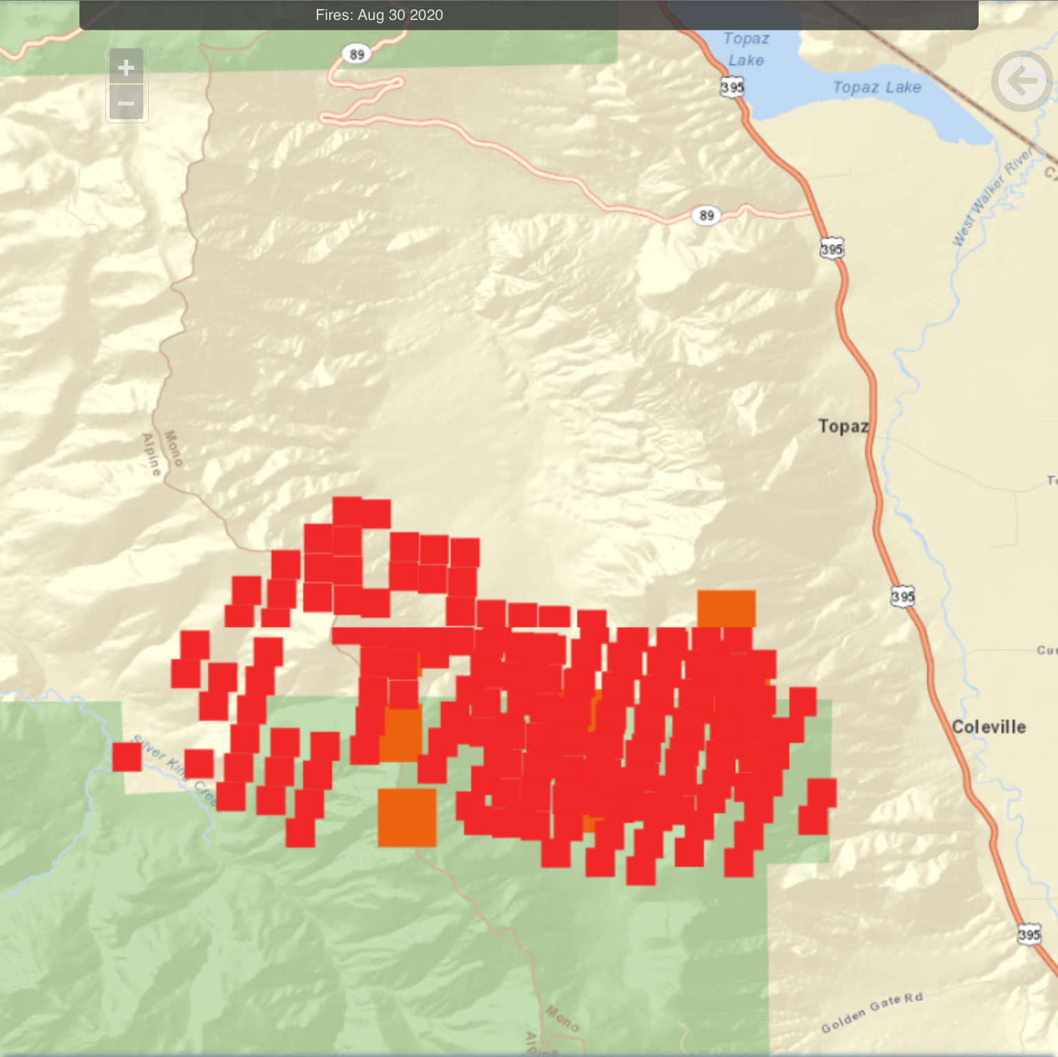
IR map showing 4055 acres as of 1800 last night
Took off around 15:00.
Started a good run around 17:00.
@19:00- Mandatory Evacs for Coleville and Walker both sides of the highway.
8 miles of HWY 395 close between Topaz lane north of Coleville, To Eastside lane in Walker.
@18:45 The fire was 1.5 miles due west of Walker, approaching Mill Canyon road.
Evacuation orders?
Coleville and Walker both sides of highway.
Sounds like all of Walker and north to Cunningham lane?
Edit* oh sorry, yes, mandatory evacuations are same as evacuation order.
2 Likes
8400 acres on IR this morning
1 Like
From Mammoth Times FB: facebook.com/photo.php?fbid=10222467847300633&set=a.1216518928778&type=3&theater
13,200 acres on IR this morning
1 Like
14800 on IR, looks like it’s pushing southwest.
1 Like
16,200 acres on IR, activity on all flanks except the north end.
1 Like
18,000 acres on IR, active on the south and west flanks.
1 Like