State ID: NV
3 letter designator: TMF
Fire name: Poeville
Location: Poeville Road; Peavine Peak W/O Reno, NV
Reported acres: 100+
Rate of spread: rapid
Report on Conditions: The fire started last night from a vehicle fire at the 7,000’ elevation level. It was initially contained @ 1.4 acres but strong winds have caused an escape and the fire is expected to impact Reno in the next few hours.
Structure threat: yes, voluntary evacuations in a 3 mile area around Seneca Dr. off Golden Valley exit
Evacuation center: senior center at 9th and Wells. Livestock evacuation center is Reno Livestock events Center.
Resources: AA, T88, T89, T102, T104, T107, T839, T861, VLAT T914, Scoopers 260, 263
Hazards:
Weather: Current conditions: https://www.wrh.noaa.gov/mesowest/timeseries.php?sid=PVPN2&num=72&banner=gmap&raw=0&w=325
Red Flag Warning noon today to 11 pm Sunday.
West winds 15-30 MPH gusts 45-55 mph. Ridgetop gusts 70 mph. RH 5-15%
Radio channels:
Scanner link: https://www.broadcastify.com/webPlayer/7364
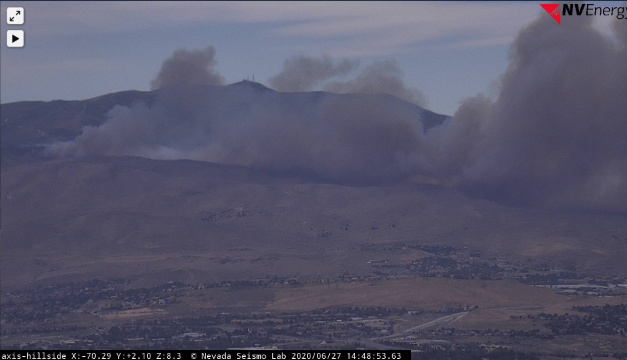
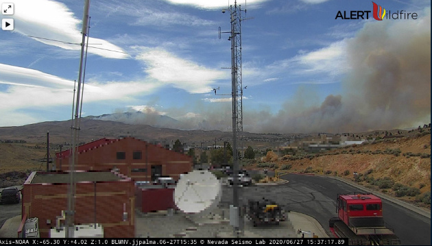
Webcam link: http://www.alertwildfire.org/tahoe/index.html?camera=Axis-NOAA&v=81e003f
http://www.alertwildfire.org/tahoe/index.html?camera=Axis-Peavine&v=81e003f
http://www.alertwildfire.org/tahoe/index.html?camera=Axis-Hillside&v=81e003f
http://www.alertwildfire.org/tahoe/index.html?camera=Axis-McPeak&v=81e003f
http://www.alertwildfire.org/tahoe/index.html?camera=Axis-Steamboat&v=81e003f
Live Video: https://www.facebook.com/krnvnews4/videos/282766392974654/
https://www.facebook.com/FOXBaltimore/videos/296363621507348/
Agency Website: https://inciweb.nwcg.gov/incident/6810/
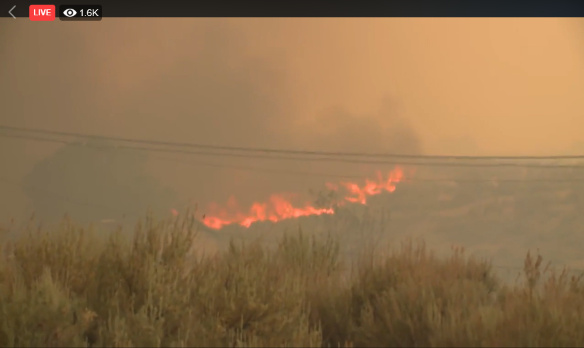
Conditions changing rapidly. Fire making a big push now.
TMFD had the name as ‘Poeville’ but has since changed it to ‘Poleville’
Mandatory evacuations for West Golden valley road and Sauvignon court.
More Evacuations: Seneca, Kiowa, Blackfoot, Chippewa, Dakota, Haida Ct, Sauk, Hopi Lane and Hopi Ct, Mandan Way, Peavine Peak Rd.
https://www.wrh.noaa.gov/mesowest/timeseries.php?sid=PVPN2&num=72&banner=gmap&raw=0&w=325
They changed it to Poleville but it’s actually Poeville.
250 acres.
Multiple structures on fire at Kennedy x Virginia.
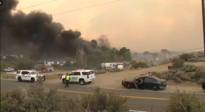
Photo from a nearby neighborhood of approaching fire: https://twitter.com/WadeReno/status/1277011473097609218
Tanker 88, 89, 861, 839, 102, 104, 107, Scoopers 260, 263
Tanker 914 is enroute.
A post was merged into an existing topic: TMFX poeville rd??
Trucker Meadows Fire Protection District and The Humboldt-Toiyabe NF are in unified command on this incident.
Drone near the fire is delaying aircraft from working the fire…
Reno/Stead (KRTS) Severity:71
| TIME | RH | WIND | TEMP | FUEL |
|---|---|---|---|---|
| 05:35PM | 9% | WSW22G32mph | 86 | |
| 04:55PM | 9% | WSW24G39mph | 88 | |
| 03:55PM | 12% | WSW24G36mph | 88 | |
| 02:55PM | 13% | SW29G44mph | 88 | |
| 01:55PM | 12% | SW24G35mph | 86 | |
| 12:55PM | 10% | WSW25G35mph | 90 |
First homes impacted were from a spot fire that burned structures at Heindel x Virginia.
The left flank is now back into alignment and making a big run towards homes on Seneca x Kiowa
Right flank has reached homes on Gladstone Drive
New evacuation: Hoge Road south to Rancho San Rafael Regional Park, west of Virginia St.
EDIT - Will try again.
Hope this works. Screen capture of last hour from Hillside cam.
Camera shaking in wind.
Strike Team 2330 C just dispatched by Grass Valley.
Engines 2353, 2385, 2383, 2365, 2393 ( I think…)
Winds in Tahoe are strong, and gusty.
http://www.alertwildfire.org/blmnv/index.html?camera=Axis-Hillside&v=81e003f
(I’m not good at screen shots)
Here’s the link…you can always rewind to see the 15 min, last hour, etc. Watching this tonight will be interesting.
Took another shot at video, this time with proper resolution. Problem is it takes 20 minutes with my connection to upload.