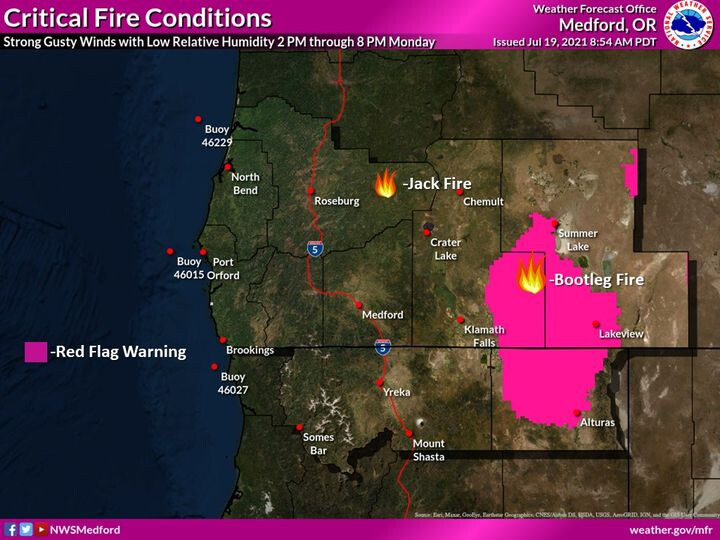
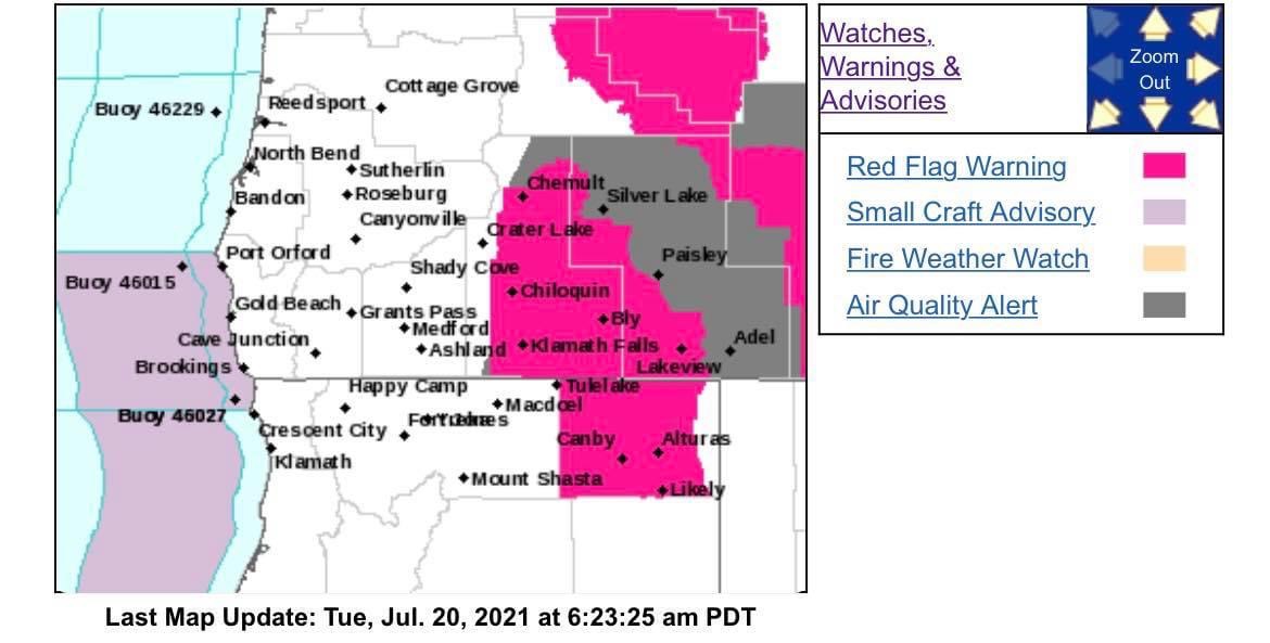
Another day, another red flag warning-
RED FLAG WARNING REMAINS IN EFFECT FROM 2 PM THIS AFTERNOON TO 8 PM PDT THIS EVENING FOR STRONG GUSTY WIND WITH LOW RH FOR FIRE WEATHER ZONE 624…
FIRE WEATHER WATCH REMAINS IN EFFECT FROM TUESDAY AFTERNOON THROUGH TUESDAY EVENING FOR STRONG GUSTY WIND WITH LOW RH FOR FIRE WEATHER ZONE 624…
-
Impacts: Strong, gusty wind with low relative humidity and critically dry vegetation will greatly increase the spread potential of any new and existing fires.
-
Affected area: In South Central OR…Southeastern Fire Weather Zone 624, including the Bootleg Fire, and the communities of Bly, Bonanza, Lakeview, and Valley Falls.
-
Wind: West 10 to 20 mph with gusts up to 30 mph.
-
Humidity: 10 to 15 percent.
-
View the hazard area in detail at:
https://www.wrh.noaa.gov/mfr/HAZARD
RED FLAG WARNING REMAINS IN EFFECT FROM 2 PM THIS AFTERNOON TO 8 PM PDT THIS EVENING FOR STRONG GUSTY WIND WITH LOW RH FOR FIRE WEATHER ZONE 285…
FIRE WEATHER WATCH REMAINS IN EFFECT FROM TUESDAY AFTERNOON THROUGH TUESDAY EVENING FOR STRONG GUSTY WIND WITH LOW RH FOR FIRE WEATHER ZONE 285…
-
Impacts: Strong, gusty wind with low relative humidity and critically dry vegetation will greatly increase the spread potential of any new and existing fires.
-
Affected area: In Northern CA…Most of Fire Weather Zone 285. This includes the communities of Alturas, Canby, Adin, and Likely.
-
Wind: Southwest 10 to 20 mph with gusts up to 30 mph.
-
Humidity: 9 to 15 percent.
-
View the hazard area in detail at:
https://www.wrh.noaa.gov/mfr/HAZARD
2 Likes
DATA PACKAGE IS UP AT MAPS.TAKSERVER.US
3 Likes
From ODF-
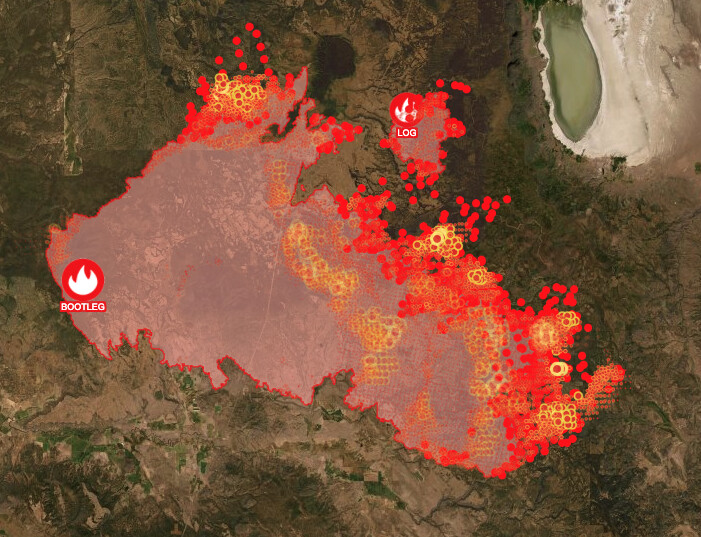
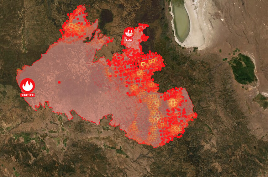
Klamath Falls, ORE. – Yesterday was the ninth day in a row with such extreme fire behavior that firefighters moved to safety zones and looked for opportunities to re-engage. Please note: The fire map issued today does not reflect the actual fire perimeter as the infrared data collection flight was not performed due to aircraft mechanical issues.
There was active fire all night on the southeastern corner. A fire slop over across the 28 Road is estimated to be over 2,500 acres in the Elder Creek area. Firefighters worked through the night to limit growth. On the north edge, firefighters disengaged when the fire aggressively moved past retardant lines three to four miles north toward Long Creek. The Nature Conservancy station at Sycan Marsh was evacuated and firefighters provided structure protection. Fire activity on the Log Fire was moderated by heavy smoke cover (shading from smoke cover results in lower fire intensity) and firefighters were successful in limiting southeast growth toward Summer Lake with dozer lines.
“We are running firefighting operations through the day and all through the night,” said Joe Hessel, Incident Commander. “This fire is a real challenge, and we are looking at sustained battle for the foreseeable future.”
Weather today will add the possibility of thunderstorms to the dry, hot, and windy conditions, with fire growth expected to the north, east, and southeast. Today, crews will work to contain the slop over the 28 Road and scout for contingency lines. Crews are also managing smaller areas of fire outside of the containment lines. The southeast flank of the fire from Preacher Flats to Mitchell Monument remains in patrol status. More firefighters have shifted to the north to support fire efforts near Silver Lake. Firefighters on the Log Fire continue line improvements to attempt to protect ranches and the Summer Lake community. Firefighters are preparing secondary firelines in all areas of fire growth. The southwestern flank of the fire continues to hold. It is imperative property owners use caution when returning; there are lingering hot spots and fire-weakened trees. The public may see smoke as fuels continue to burn within the fire perimeter. Please use an abundance of caution around these areas.
5 Likes
Estimated acreage as of this morning, 343,755 that’s up over 50,000 acres yesterday.
6 Likes
Lake County Sheriff’s Office Media Release
Lakeview, OR – Evacuations. Additional evacuation levels have been implemented in Lake County due to increased activity on the Bootleg and Log Fires. Lake County utilized its emergency alert system to notify residents in the affected areas by Wireless Emergency Alert, text, email, and phone. Law enforcement agencies are also attempting to reach all affected residents, door-to-door.
Level 3 – GO NOW!
From Mile Post 73 on Highway 31 south along Winter Ridge to Government Harvey Pass, then east to the Highway 31 and Government Harvey junction, then back north to include both sides of Highway 31. This area is south of the community of Summer Lake.
Level 2 – Be SET!
From Picture Rock Pass south along Winter Ridge to Mile Post 73 and east of the middle of Summer Lake to Government Harvey Pass, then east of Slide Lake Trailhead to west of the Red House Road junction with Highway 31, then back north including Summer Lake Flats and the Ana Subdivision.
These evacuations extend and/or change the currently implemented levels. The most effective method for viewing current evacuation levels is by using the link to the interactive map below.
4 Likes
387,000+ acres this morning.
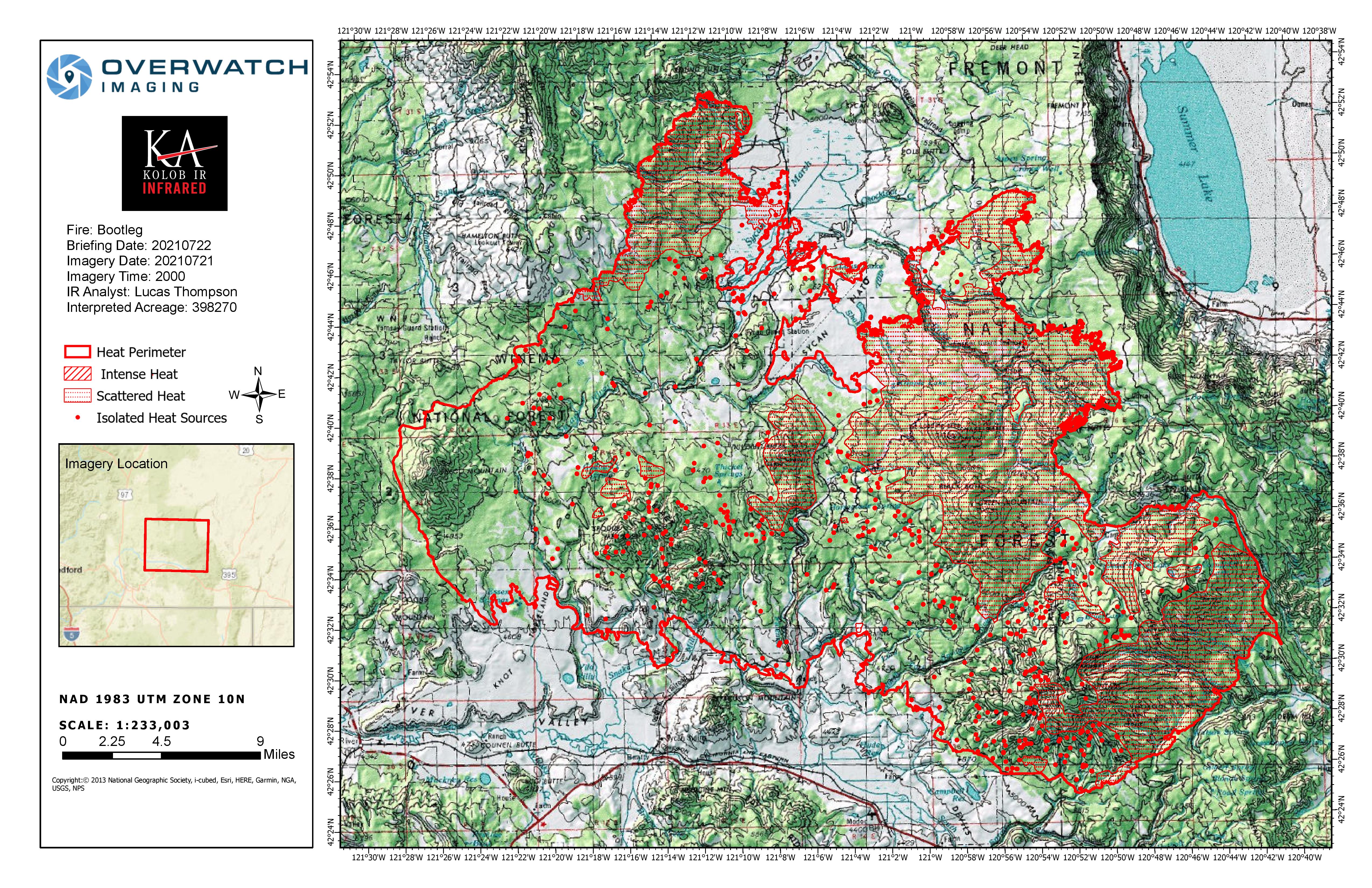
20210720_Bootleg_IR_Topo_11x17.pdf (2.0 MB)
4 Likes
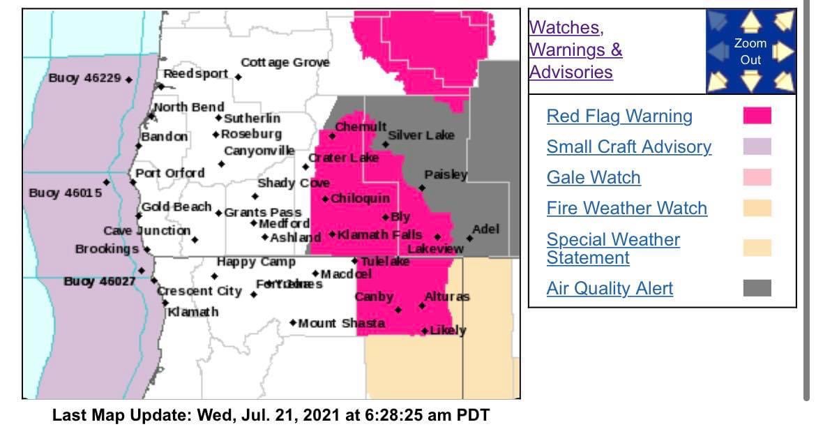
Another Red Flag for the Klamath Basin.
RED FLAG WARNING REMAINS IN EFFECT FROM 2 PM TO 8 PM PDT TUESDAY FOR STRONG GUSTY WIND WITH LOW RH FOR FIRE WEATHER ZONE 624 AND HAINES INDEX OF 6 OVER THE BOOTLEG FIRE…
FIRE WEATHER WATCH REMAINS IN EFFECT FROM WEDNESDAY AFTERNOON THROUGH WEDNESDAY EVENING FOR STRONG GUSTY WIND WITH LOW RH FOR FIRE WEATHER ZONE 624…
-
Impacts: Strong, gusty wind with low relative humidity and critically dry vegetation will greatly increase the spread potential of any new and existing fires. In addition, very dry and unstable conditions will support extreme fire behavior. Plume dominated fire behavior is possible with locally-generated erratic and gusty winds. Spotting could be problematic.
-
Affected area: In South Central OR…Southeastern Fire Weather Zone 624, including the Bootleg Fire, and the communities of Bly, Bonanza, Lakeview, and Valley Falls.
-
Wind: Southwest to west 10 to 20 mph with gusts up to 30 mph.
-
Humidity: 9 to 15 percent.
-
View the hazard area in detail at: https://www.wrh.noaa.gov/mfr/HAZARD
RED FLAG WARNING REMAINS IN EFFECT FROM 2 PM TO 8 PM PDT TUESDAY FOR STRONG GUSTY WIND WITH LOW RH FOR FIRE WEATHER ZONE 285…
…FIRE WEATHER WATCH REMAINS IN EFFECT FROM WEDNESDAY AFTERNOON THROUGH WEDNESDAY EVENING FOR STRONG GUSTY WIND WITH LOW RH FOR FIRE WEATHER ZONE 285…
-
Impacts: Strong, gusty wind with low relative humidity and critically dry vegetation will greatly increase the spread potential of any new and existing fires.
-
Affected area: In Northern CA…Most of Fire Weather Zone 285. This includes the communities of Alturas, Canby, Adin, and Likely.
-
Wind: Southwest 10 to 20 mph with gusts up to 30 mph.
-
Humidity: 9 to 15 percent.
-
View the hazard area in detail at:
https://www.wrh.noaa.gov/mfr/HAZARD
4 Likes
data package up at maps.takserver.us
1 Like
On the south east corner it has hit the 2018 Watson creek burn.
3 Likes
Incident Information
Basic Information
Current as of 7/21/2021, 5:41:32 AM
Incident Type Wildfire
Cause Lightning / Natural
Date of Origin Tuesday July 06th, 2021 approx. 01:42 PM
Location 15 miles NW of Beatty, Oregon
Incident Commander Joe Hessel/Lance Lightly/Rob Allen
Coordinates 42.616 latitude, -121.421 longitude
Current Situation
Total Personnel 2,250
Size 394,407 Acres
Percent of Perimeter Contained 32%
Fuels Involved
Mixed grass/shrub, timber with understory, timber with litter fuel types.
Significant Events
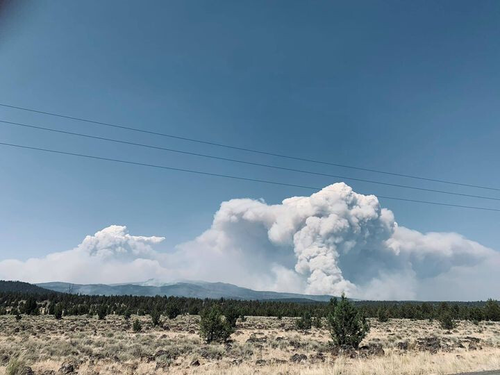
Extreme, crowning, running, spotting. Aggressive rates of spread in critically dry fuels across all size classes. Spot fires immediately exhibiting fire characteristics in the extreme class with close to 100% ignition rate in unshaded receptive fuels. Closed timber stands easily sustaining short to moderate duration crown runs. Pyrocumulus development in several areas of the fire.
Outlook
Planned Actions
Patrol and mopup south and west edge of fire, construct direct line to the North and Northeast, scout and construct contingency lines.
Projected Incident Activity
The fire will continue to be extremely active with gusty winds and extremely dry fuels. Significant acreage increase potential on the northern and eastern side of the fire. Rapid fire spread with high intensity fire behavior. Fire will continue to move East/Northeast. Significant amounts of smoke will be present during day and night.
Current Weather
Weather Concerns
Showers overnight helped RH recoveries into the 70-75% range to start out the day. Temperatures rose into the upper 80s with lower 80s at higher elevations. RH fell into the 15-20% range. Some areas of critical fire weather developed with southwest winds of 10-15mph with gusts to 25mph. A red flag warning was in pace for the gusty winds and dry conditions. Cumulus clouds developed in the afternoon but showers remained well east of the fire area.
2 Likes
Another red flag warning today:
RED FLAG WARNING REMAINS IN EFFECT FROM 2 PM THIS AFTERNOON TO 8 PM PDT THIS EVENING FOR STRONG GUSTY WIND WITH LOW RH FOR FIRE WEATHER ZONE 624…
-
Impacts: Strong, gusty wind with low relative humidity and critically dry vegetation will greatly increase the spread potential of any new and existing fires.
-
Affected area: In South Central OR…The southeast portion of Fire Weather Zone 624 in Lake County, including Lakeview and Valley Falls.
-
Wind: West 10 to 15 mph with gusts up to 25 mph.
-
Humidity: 8 to 12 percent.
-
View the hazard area in detail at: https://www.wrh.noaa.gov/mfr/HAZARD
RED FLAG WARNING REMAINS IN EFFECT FROM 2 PM THIS AFTERNOON TO 8 PM PDT THIS EVENING FOR STRONG GUSTY WIND WITH LOW RH FOR FIRE WEATHER ZONE 285…
FIRE WEATHER WATCH IN EFFECT FROM THURSDAY AFTERNOON THROUGH THURSDAY EVENING FOR STRONG GUSTY WIND WITH LOW RH FOR FIRE WEATHER ZONE 285…
The National Weather Service in Medford has issued a Fire Weather Watch…which is in effect from Thursday afternoon through Thursday evening.
-
Impacts: Strong, gusty wind with low relative humidity and critically dry vegetation will greatly increase the spread potential of any new and existing fires.
-
Affected area: In Northern CA…For the Warning, All of Fire Weather Zone 285.
For the Watch, Central Fire Weather Zone 285 from Tionesta east to Davis Creek.
-
Wind: West 10 to 15 mph with gusts up to 25 mph.
-
Humidity: 7 to 11 percent.
-
View the hazard area in detail at:
https://www.wrh.noaa.gov/mfr/HAZARD
3 Likes
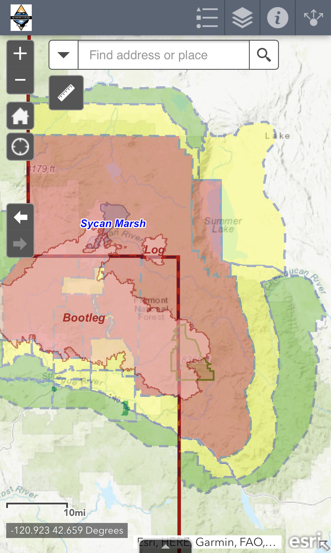
NEW EVACUATION LEVELS IN KLAMATH COUNTY
The following changes in the evacuation levels are for immediate release:
Previously Level 1 areas south of Highway 140 from the lake county line extending west, have been removed.
Previously Level 2 areas south of the fire perimeter and west of Ivory Pine Rd including the upper tablelands and Oregon Pines areas have been reduced to Level 1 (BE READY) evacuation notice.
All other evacuation levels for Klamath County remain in place at this time.
Residents returning to fire damaged areas are urged to exercise extreme caution as hazards such as damaged trees remain. In addition roads in the fire damaged areas are open only to residents and emergency crews only.
An interactive map of the evacuation zones can be found at:
www.tinyurl.com/Bootlegevac
5 Likes
ATAK Data Package posted at maps.takserver.us
2 Likes
398,000+ acres makes it the 3rd largest fire in Oregon history.
6 Likes
Data Package posted at maps.takserver.us
1 Like
400,389 acres and 40% contained.
5 Likes
408,930 acres and 46% contained.
4 Likes