ATAK DATA PACKAGE CREATED - maps.takserver.us
Everything in this package is georeferenced today.
ATAK DATA PACKAGE CREATED - maps.takserver.us
Everything in this package is georeferenced today.
Update- Bootleg. OR-FWF-210321. Unified Command: IMT1, PNW Team 2 (Allen), IMT1, ODF Team 1 (Hessel) & OSFM Green Team (Hallman). 15 mi NW of Beatty, OR. Start 7/6. Full Suppression. Cause: Unknown. 273,582 acres (+46,348). 22% containment. Extreme fire behavior. Timber and brush. Structures threatened. Evacuations in effect. Road and area closures.
What agency is OSFM
Oregon State Fire Marshall
Copy thanks
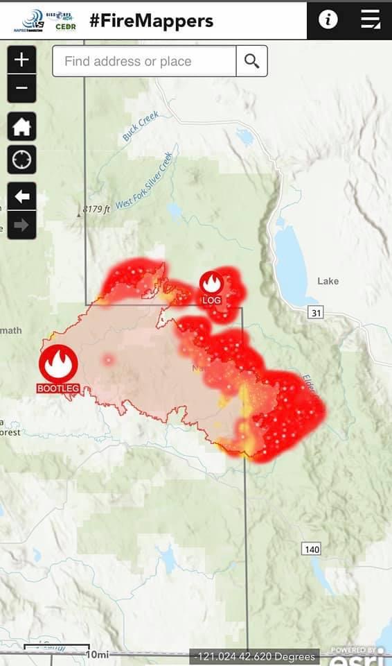
The Caltopo map is 3-4 hours behind real time in heat signatures. Zoom in to see time stamp at fires edge.
CalTopo - Backcountry Mapping Evolved
ATAK Data Package is up. maps.takerserver.us
Bootleg. OR-FWF-210321. Unified Command: IMT1, PNW Team 2 (Allen), IMT1, ODF Team 1 (Hessel) & OSFM Green Team (Hallman). 15 mi NW of Beatty, OR. Start 7/6. Full Suppression. Cause: Unknown. 290,196 acres (+16,614). 22% containment. Extreme fire behavior. Timber and brush. Structures threatened. Evacuations in effect. Road and area closures.
RED FLAG WARNING REMAINS IN EFFECT FROM 2 PM THIS AFTERNOON TO 8 PM PDT THIS EVENING FOR STRONG GUSTY WIND WITH LOW RH FOR FIRE WEATHER ZONE 624 AND HAINES INDEX OF 6 OVER THE BOOTLEG FIRE…
FIRE WEATHER WATCH IN EFFECT FROM MONDAY AFTERNOON THROUGH MONDAY EVENING FOR STRONG GUSTY WIND WITH LOW RH FOR FIRE WEATHER ZONE 624…
The National Weather Service in Medford has issued a Fire Weather Watch…which is in effect from Monday afternoon through Monday
evening.
Impacts: Strong, gusty wind with low relative humidity and critically dry vegetation will greatly increase the spread potential of any new and existing fires. In addition, very dry and unstable conditions will support extreme fire behavior today. Plume dominated fire behavior is possible with locally-generated erratic and gusty winds. Spotting could be problematic.
Affected area: In South Central OR…Southeastern Fire Weather Zone 624, including the Bootleg Fire, the communities of Bly and Bonanza. The Fire Weather Watch for Monday affects similar areas, with the addition of Lakeview and Valley Falls.
Wind: Southwest 10 to 20 mph with gusts up to 35 mph.
Humidity: As low as 8 percent today. 10 to 15 percent Monday.
Haines Index: 6 (High) this afternoon.
View the hazard area in detail at:
https://www.wrh.noaa.gov/mfr/HAZARD
Ooof. Likely to be another big day today, Red Flag Warning posted and Haines of 6.
Not much being posted on this fire…but HS it looks to be blowing up!!!
GOES-West - Sector view: Pacific Southwest - GeoColor - NOAA / NESDIS / STAR
I was wondering where this ranked in terms of large fires in Oregon. Looks like it’s currently 4th at 293,000+ acres, behind the Long Draw (2012, 558,198 acres); Biscuit (2002, 500,000 acres); and Buzzard Complex (2014, 395,747 acres). From the pic @Swocaptain posted, looks to be adding a bunch more acreage today.
I do believe that was an forceivable event…not great…but this monster is still moving
I was hoping it would trip over the Log and fall on its face. I am beginning to believe this fire started from a meth lab because it has been going crazy for 12 days and shows no sign of calming down.
Try this Caltopo map with heat signatures. Play with the layers you can add
in the right column. It’s normally 3 hours behind in plotting the fire heat. Zoom in for
'detailed topo features:
https://caltopo.com/map.html#ll=42.70721,-120.99665&z=11&b=t&o=f16a%2Cr&n=1,0.25&a=modis_mp
It will update about every 3- 4 hours.
Bootleg hasn’t merged with Logs yet but should during today’s operational period.