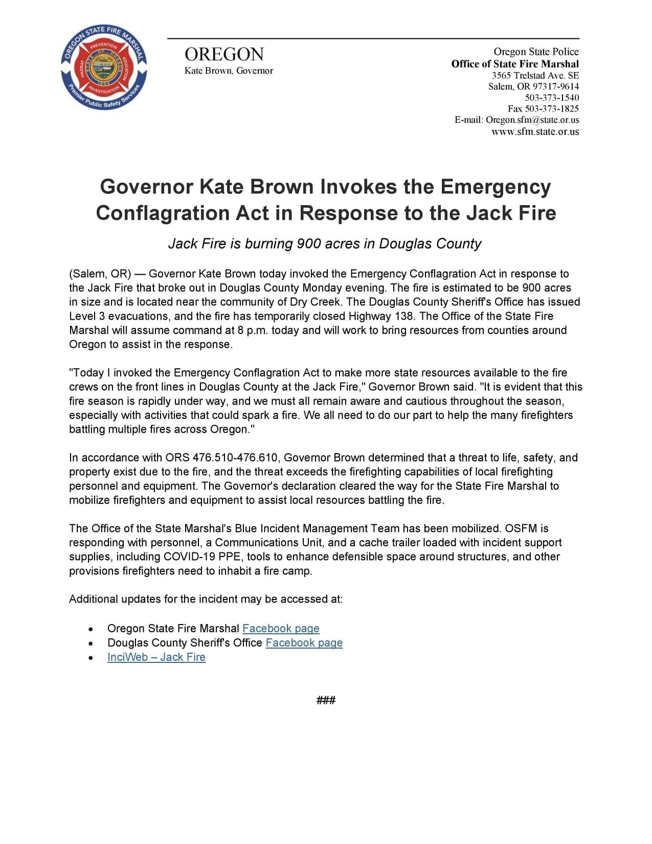
Jack Incident - IA 7/5
7/6 (ICT3) 20 mi E of Glide, OR. Start 7/5. Full Suppression. Cause: Unknown. 500 acres. 0% containment. Active fire behavior. Timber and brush. NW Team 9 (Goff) mobilizing with in brief today at 1800.
Jack Incident - IA 7/5
7/6 (ICT3) 20 mi E of Glide, OR. Start 7/5. Full Suppression. Cause: Unknown. 500 acres. 0% containment. Active fire behavior. Timber and brush. NW Team 9 (Goff) mobilizing with in brief today at 1800.
A LEVEL 3 EVACUATION - GO! NOTICE NOW ORDERED FOR ALL HOMES LOCATED IN THE FOLLOWING AREAS DUE TO THE #JACKCREEKFIRE:
** ALL RECREATION AREAS, HOMES AND BUSINESSES LOCATED BETWEEN MILE MARKER 43 EAST TO EAGLE ROCK CAMPGROUND.
Level 3 or “GO!”:
• If you chose not to evacuate, emergency services may not be able to assist you further.
• Grab your “go kit” and leave immediately.
• Follow your evacuation plan and stay informed.
Danger to the evacuated area is current and imminent and you should evacuate immediately. If you choose to ignore this advisement, you must understand that emergency services may not be available to assist you further. Do not delay leaving to gather any belongings or make efforts to protect your home. This will be the last message you receive.
LEVEL 2 “BE SET”: YOU MUST PREPARE TO LEAVE AT A MOMENTS NOTICE. This level indicates there is significant danger to your area, and residents should either voluntarily relocate to a shelter or with family/friends outside of the affected area, or if choosing to remain, to be ready to evacuate at a moment’s notice. Residents MAY have time to gather necessary items, but doing so is at their own risk. THIS MAY BE THE ONLY NOTICE YOU RECEIVE. Emergency services cannot guarantee that they will be able to notify you if conditions rapidly deteriorate.
*** A LEVEL 2 “BE SET” NOTICE HAS BEEN ISSUED FOR EVERYTHING EAST OF EAGLE ROCK CAMPGROUND TO SODA SPRINGS.
For more information about the fire, please follow official sources of information only.
An interactive map can be found at www.dcso.com/evacuations
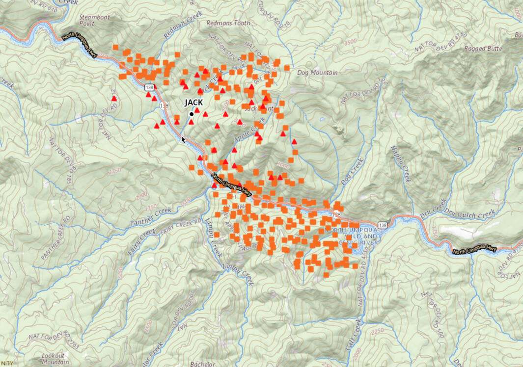
Heat Map- National Fire Situational Awareness
About 160 structures in all three zones.
The area downstream on South side of River burned last fall.
Fire is on N side if River, approximately centered in this image.
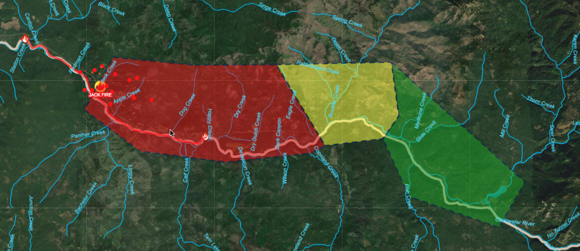
Update from IC is 900 acres as of 1500.
Resources currently assigned include 9 engines, 2 hand crews, 3 water tenders, 3 heavy helicopters, 1 light helicopter, 3 air tankers, and 2 fixed wings (with lead plane).
Fire has 2020 Archie Fire to SW, 2017 Happy Dog fire to the NE. 2002 Apple Fire is to the south.
https://mappingsupport.com/p2/gissurfer.php?center=43.322242,-122.677460&zoom=13&basemap=ESRI_scanned_topo_USA&overlay=VIIRS_24_hours,MODIS_24_hours,State_boundary,Wildland_fire_name,Historic_perimeters,ESRI_roads_and_labels&txtfile=https://mappingsupport.com/p2/special_maps/disaster/USA_wildland_fire.txt
Love the maps from this guy. He’s an ultra-volunteer! Thanks, @MappingSupport
#JackFire update: Both OSFM Blue Incident Management Team and NW Team 9 arrived and briefed on the #JackFire yesterday evening. These Teams will be in unified command. OSFM’s Team will be providing support to the local structural firefighting resources to protect life and structures. An aerial infrared flight has been ordered to determine an accurate acreage of the Jack Fire.
Looks like the fire jumped the highway
That’ll put it into 19 year old burn from the 2002 Tiller/Apple Complex. I think those fires went thru at least 7 Type 1 Teams. The ICP had its own zip code by the time it was over.
The 2002 Tiller Complex had dozens of large fires. Simultaneously, the Biscuit Fire was chewing on 500,000 acres to the West. Fires on the Westside of the Cascades in big 1st and 2nd growth timber are a different kind of animal from ones burning tree farm lands on their 4th or 5th rotation.
They are driven more by heat than anything, and take a huge amount of work and resources to corral and mop up. We can’t put them all out. And the fires did a whole lot of good.
Jack Fire. OR-UPF-000265. IMT2, NW Team 9 (Goff) & OSFM Blue Team (Magers). 20 mi E of Glide, OR. Start 7/5. Full Suppression. Cause: Unknown. 12,533 acres (+1,596). 8% containment. Active fire behavior. Timber and brush. Structures threatened. Evacuations in effect. Road, trail and area closures.
The 7/13/2021 daily update for the Jack Fire ![]() Acreage is estimated at 13,795 and is 15% contained. OSFM’s Task Forces have demobilized and delegation of authority transferred back to Douglas Fire Protective Association. Structures have been prepped, structure protection enhanced and will be monitored by DFPA and NW Team 9. This will be the last update on OSFM’s page on the Jack Fire.
Acreage is estimated at 13,795 and is 15% contained. OSFM’s Task Forces have demobilized and delegation of authority transferred back to Douglas Fire Protective Association. Structures have been prepped, structure protection enhanced and will be monitored by DFPA and NW Team 9. This will be the last update on OSFM’s page on the Jack Fire.
Jack Fire. OR-UPF-000265. IMT2, NW Team 9 (Goff). 20 mi E of Glide, OR. Start 7/5. Full Suppression. Cause: Unknown. 16,667 acres (+1,419). 35% containment. Moderate fire behavior. Timber and brush. Structures threatened. Evacuation notices. Road, trail and area closures.
Jack Fire. OR-UPF-000265. IMT2, NW Team 9 (Goff). 20 mi E of Glide, OR. Start 7/5. Full Suppression. Cause: Unknown. 17,092 acres (+328). 50% containment. Moderate fire behavior. Timber and brush. Structures threatened. Evacuation notices. Road, trail and area closures. IMT2, NW Team 10 (Lawson) is mobilizing with inbrief today at 1700.