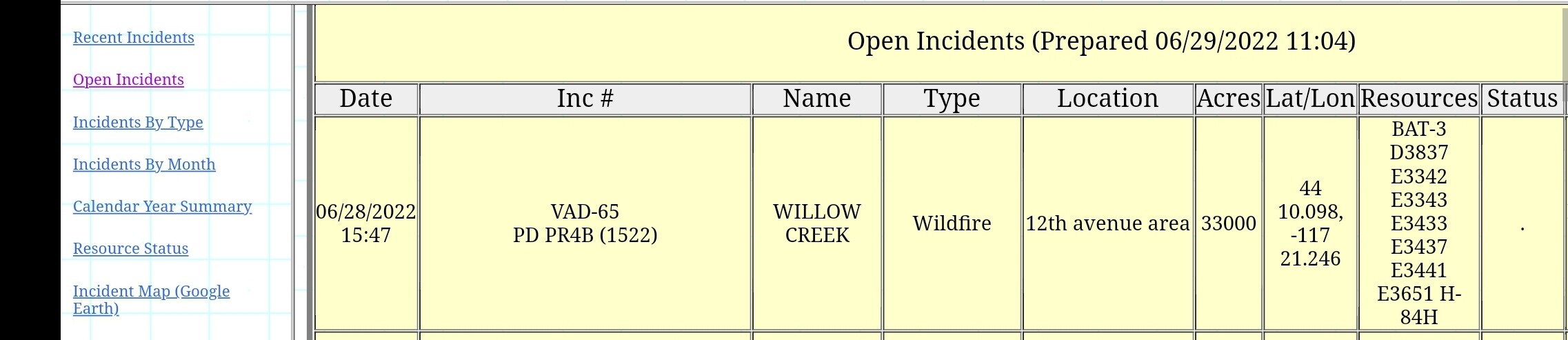
WILDFIRE ACTIVITY - OREGON: The “Willow Creek Fire” burning well east of Burns in Malheur County, Oregon is now over 40,000 acres and continues to spread.
3 Likes
44 10.098, -117 21.246
BAT-3 D3837 E3342 E3343 E3433 E3437 E3441 E3651 H-84H
Wildfire - #WillowCreekFire #OR Map Link: ArcGIS Web Application
2 Likes
Any updates on this one?
Nothing I’ve seen. I’ll keep looking.
1 Like
3 Likes
FIRE UPDATE  : The #WillowcreekFire near Vale, Oregon, is at 45% containment this morning.
Overnight fire activity was light, and the estimated acreage burned is now 42,000 acres.
“We’re getting around it,” said Justin Fenton, BLM Fire Duty Officer. “We’re continuing to patrol and monitor, and crews are focusing on putting out hot spots.”
No structures are threatened, and no evacuations have been ordered.
Today’s forecast calls for hotter drier conditions, but winds are expected to remain light.
Yesterday, crews used dozer lines and strategic ignitions to halt the fire’s progression along the west side of Interstate 84 near mile marker 359, creating a secure barrier between the fire and the roadway.
The fire is burning in grass and sagebrush on BLM public lands and private land.
The fire was reported on private land Tuesday afternoon, then crossed onto lands managed by Vale BLM. The cause is still under investigation.
Please help our firefighters by keeping a safe distance and avoiding fire operations!
 Read yesterday’s report: https://bit.ly/3I2pgjP
 Jeremy Cowie and Justin Robinson, BLM
#FireYear2022 #WildfireReady #ThankYouFirefighters Bureau of Land Management Fire #wildfire
 Wildfire information:
- BLM OR/WA Fire Restrictions and Closures: http://ow.ly/JRQI50Ji5x9
- Northwest Coordination Center Seasonal Outlook: http://ow.ly/QCiZ50Ji5x8
- Map of active wildfires in the PNW from National Interagency Fire Center: http://ow.ly/aSpr50Ji5x7
- Stay safe this fire season with Firewise USA: http://ow.ly/Ec9s50Ji5xa
2 Likes