Oregon Fire Wx & News 2022

Your Friday wildland fire :fire::fire::fire: update!

:white_check_mark:Wetting rains were recorded in northwestern Washington along the coast range. Southeastern Oregon experienced continued isolated thunderstorms produced lightning and trace amounts of precipitation.

:four: New Fires

:white_check_mark:
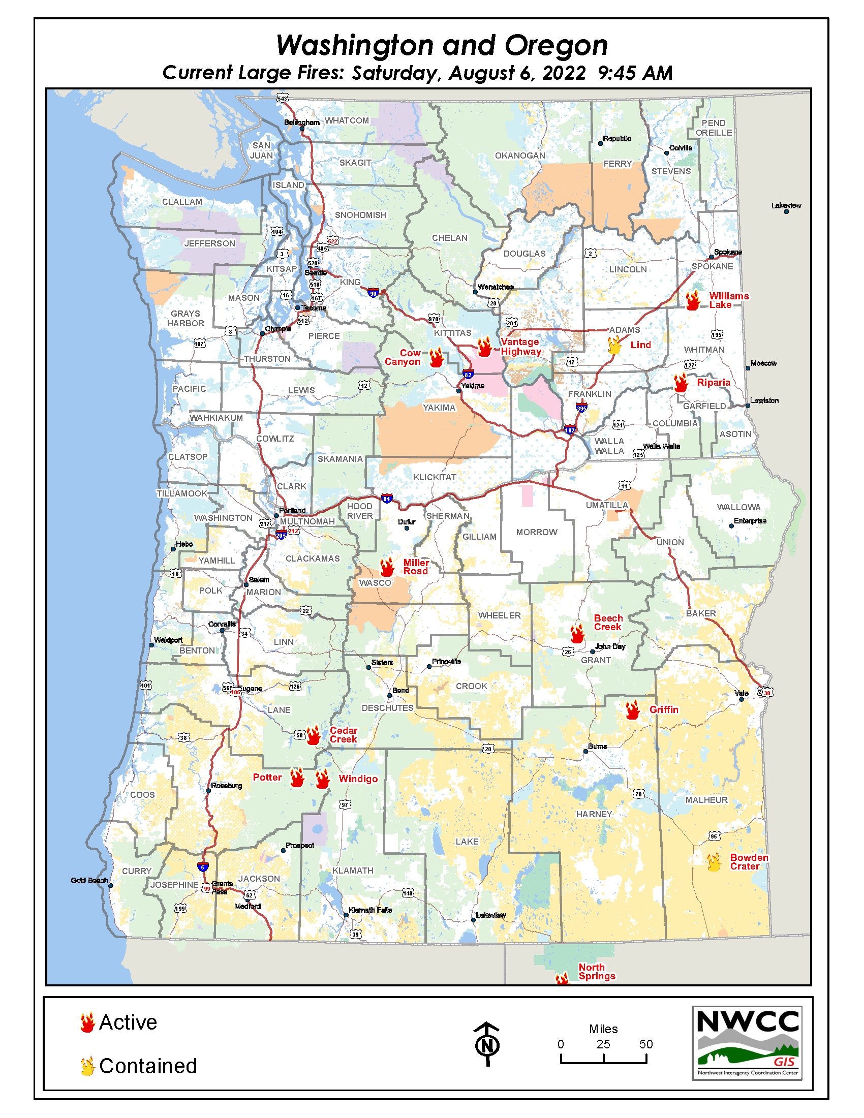
The Griffin Fire 10 miles NW of Drewsey, OR is 450 acres and 0% contained.

:white_check_mark:The North Springs Fire is 43 miles E of Cedarville, CA is 950 acres and 0% contained.

:white_check_mark:The Bowden Crater Fire 15 miles SE of Burns Junction, OR is 950 acres and 0% contained.

:white_check_mark:The Lower Goose Fire 24 miles NW of Pomeroy, WA is 700 acres and 100% contained. Last report unless significant activity occurs.

:eight: Previously Reported Fires

:white_check_mark:The Miller Road Fire 8 Miles SW of Maupin, OR is 11,186 acres and 25% contained. The fire saw 686 acres of growth in the last day. Evacuations are in effect for the fire.

:white_check_mark:The Cedar Creek Fire 15 Miles E of Oakridge, OR is 830 acres and 0% contained. This lightning-caused fire saw 530 acres of growth.

:white_check_mark:
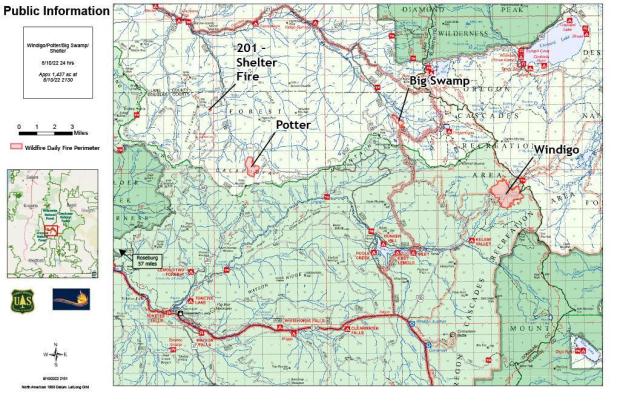
The Windigo Fire 20 miles SW of La Pine, OR is 978 acres and 0% contained.

:white_check_mark:The Potter Fire 8 Miles NE of Clearwater, OR is 125 acres and 0% contained. The fire is seeing moderate fire behavior.

:white_check_mark:The Vantage Highway 5 Miles W of Vantage, WA is 26,490 acres and 35% contained.

:white_check_mark:The Cow Canyon Fire 11 Miles N of Naches, WA is 5,600 acres and 0% contained.
Evacuations are in effect and structures are threatened.

:white_check_mark:The Williams Lake 11 Miles S of Cheney, WA is 1,500 acres and 0% contained.

:white_check_mark:The Beech Creek Fire 9 Miles S of Long Creek, OR is 248 acres and 25% contained. The fire is exhibiting moderate fire behavior.

:white_check_mark:A warming and drying spell will set in over the weekend and last through mid-week. The potential for initiation of new large fires will drop back to normal background levels for early August on Friday.

Check back here for regular updates and be sure to visit these sites for the most up-to-date wildland fire information!

:fire: NWCC Blog: http://nwccinfo.blogspot.com/
:fire: NWCC Website: NWCC :: Home
:fire: Large Fires in the Northwest: NWCC :: Home
:fire: Northwest Fire Map: NWCC :: Home
:fire: 2021 Fire Season in Review: https://youtu.be/Yz3aQSdU62Y

#ReadyForWildfire #keeporegongreen #FireYear2022 #FireSeason2022 #besafeoutthere

Your Northwest Forests U.S. Forest Service - Willamette National Forest Washington State Department of Natural Resources Oregon Department of Forestry BLM Oregon & Washington
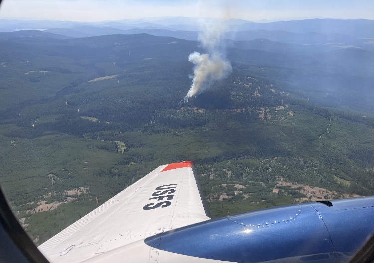
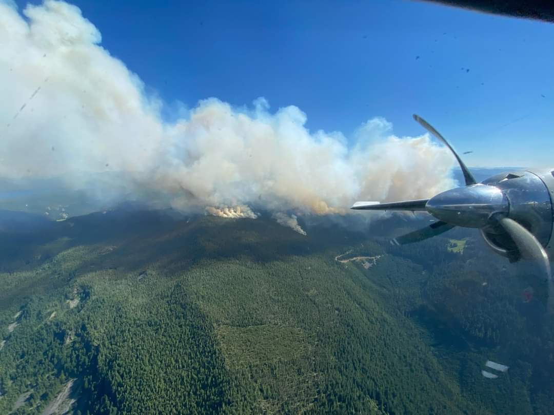
Photo :camera_flash:: Flying above the Cedar Creek Fire, August 4, 2022.

2 Likes

:fire:Update: Fire activity was relatively quiet yesterday over central Oregon. Firefighters made great progress increasing containment on existing wildfires. Only 1 new fire was reported last night.

Morning Central Oregon Interagency Dispatch Update::point_down:

2 Likes

here’s the active large fires in Oregon and Washington. There are 11 active large :fire:fires out there – 4 in Washington and 7 in Oregon.

This new :world_map: 
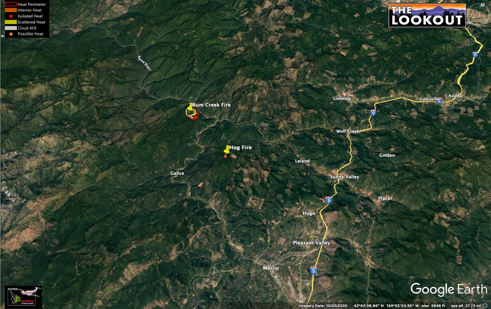
shows the exact location of the active and uncontained large fires, as of August 6, 2022.

2 Likes
1 Like

There are thunderstorms developing east of the Cascades, with a very deep inverted V profile and PWV’s only .64 on the sounding. Abundant dry lightning on dry fuels is a major major concern!

3 Likes
2 Likes
2 Likes

1 Like

1 Like
2 Likes

4 Likes

Just posting this here be it shows 4 of the fires going in #OR right now.

2022_08_11-13.35.16.224-CDT.jpeg

1 Like
2 Likes

𝙇𝙄𝙂𝙃𝙏𝙉𝙄𝙉𝙂 π™‚π™π™‡π˜Ύπ™ƒ π˜Όπ™‰π˜Ώ π™’π™€π™Žπ™π™Žπ™„π˜Ώπ™€ π˜Ύπ™Šπ™ˆπ™‹π™‡π™€π™“π™€π™Ž π™‹π™ˆ π™π™‹π˜Ώπ˜Όπ™π™€: Despite numerous fires across Jackson and Josephine counties, firefighters were able to hold the majority of containment lines on Thursday. There are currently 56 total fires across the district following Wednesday night thunderstorms across the region, breaking down to eight in Jackson County, named as the Westside Complex, and 48 in Josephine County, called the Lightning Gulch Complex. These incidents vary in stages, from active operations to 100% lined and mopped up, affecting both private and Bureau of Land Management (BLM) land.

Resources were able to hold the largest fire at an estimated 40 acres on Thursday. That incident, mistaken by nightshift crews as the Tallowbox Fire, is actually the Keeler Fire. The Tallowbox Fire, originally reported as an estimated 30 acres this morning, is actually an estimated five. These neighboring incidents are two of four fires located near Tallowbox Mountain in the Applegate Valley to the east of Thompson Creek Road. In the same area, the Ladybug Gulch Fire (pictured) proved to be the most challenging of the day, requiring multiple retardant drops from ODF Large Air Taker (LAT) 104; it’s currently holding at an estimated 21 acres. The fourth fire in this location is the Tallowbox Cutoff Fire, estimated to be 1/10th of an acre, is 100% lined and 80% mopped up.

In Josephine County, the Hog Creek Fire, located north of Merlin, and the Rum Creek Fire, located near Rum Creek north of Galice, are both estimated to be 30 acres in size. The Granite Hill Fire is estimated to be 14 acres in size, located north of Grants Pass and east of Colonial Valley.

Weather conditions aided firefighters on the line, as temperatures remained cooler than expected and predicated thunderstorms did not materialize, prompting the US National Weather Service Medford Oregon to cancel a red flag warning. These milder conditions contributed to slightly decreased fire behavior, allowing resources to hold containment lines and complete mop-up operations on some incidents.

Due to the extremely busy nature of dispatching, fires, locations, estimated sizes and containment information is still being organized. This information will be released when it is accurately complied, however priorities have remained providing updates and relaying information to our firefighters in the field and in the air on active incidents.

No homes are threatened, and no evacuation orders have been placed. Please be aware of any potential changes and follow Jackson County Emergency Management, Jackson County Sheriff Oregon, Josephine Co. Emergency Management and the Josephine County Sheriff’s Office for any evacuation information.

Fire information is always available on our website, www.swofire.com. #swofire2022 #fireseason2022

1 Like

2 Likes

𝙇𝙄𝙂𝙃𝙏𝙉𝙄𝙉𝙂 π™‚π™π™‡π˜Ύπ™ƒ π˜Όπ™‰π˜Ώ π™’π™€π™Žπ™π™Žπ™„π˜Ώπ™€ π˜Ύπ™Šπ™ˆπ™‹π™‡π™€π™“π™€π™Ž π˜Όπ™ˆ π™π™‹π˜Ώπ˜Όπ™π™€: Of the 50 plus lightning-caused fires from the August 17th thunderstorm that peppered Jackson and Josephine counties, just one fire, Rum Creek, remains without a complete containment line. The Rum Creek fire is currently estimated at about 100 acres. Collectively, the fires from the Westside and Lightning Gulch complexes have burned a little over 300 acres with Rum Creek (100), Ladybug (87), Keeler (60, pictured) and Tallowbox (26) being the largest.

Pacific Northwest Incident Management Team 13, led by Incident Commander Brian Gales, officially took command of the Rum Creek and Hog Creek fires within the Lightning Gulch Complex this morning. An official Facebook page has been created for these two incidents and all future updates will be posted here: Rum Creek Fire.

Local resources will continue to mop-up and patrol the other smaller fires in the area. Crews are also working on two lightning-caused holdover fires discovered early last night in the Jack Creek area. Each of the two fires is less than two acres in size. While a third fire was initially reported, crews have not been able to locate it; resources assigned to the other two incidents will be able to provide a swift response should the third fire not be a duplicate report.

Increased winds forecasted for this afternoon are expected to test established fire lines as crews continue the mop-up process. No homes are threatened, and no evacuation orders have been placed. Please be aware of any potential changes and follow Jackson County Emergency Management, Jackson County Sheriff Oregon, Josephine Co. Emergency Management and the Josephine County Sheriff’s Office for any evacuation information.

Firefighter success over the past week can be attributed to many things, including quick and efficient response by initial attack resources, the availability of resources at the height of fire season, and cooperating weather. The vigilance of our local communities has been just as critical in the prevention of human-caused fires that has allowed firefighters to focus on non-preventable lightning-caused fires. To date, Oregon Department of Forestry’s Southwest Oregon District has responded to 131 human-caused fires that have burned just 71 acres this year, compared to our 10-year average of 164 human-caused fires for 520 acres. These efforts have not gone unnoticed, and we appreciate the partnerships we have with our communities in keeping human-caused fires off our landscape; it has been truly appreciated over the last couple days, especially.

As a reminder, the Bureau of Land Management has closed the Rainie Falls Trail until further notice. Please help us protect firefighters and first responders by avoiding Galice Road and the Grave Creek area. The BLM is encouraging recreational boaters to avoid the river between Hellgate Canyon and Grave Creek.

Fire information is always available on our website, www.swofire.com.

Photo credit: Rural Metro Fire - Josephine County

2 Likes
2 Likes

Last night’s IR for Rum Creek and Hog. White line is 24 hrs of growth, didn’t have earlier data for Hog…

2 Likes
2 Likes