
https://www.cocorahs.org/ViewData/ListDailyPrecipReports.aspx
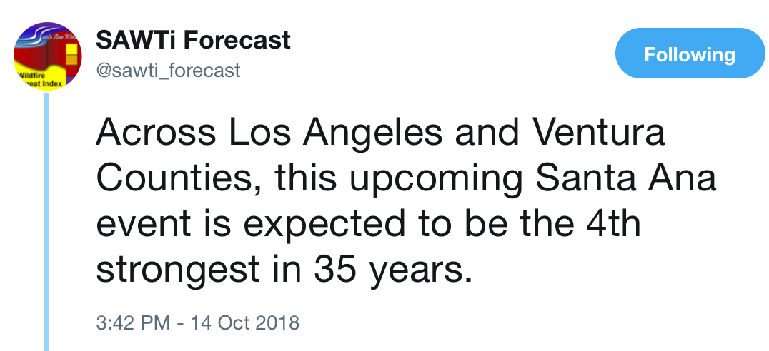
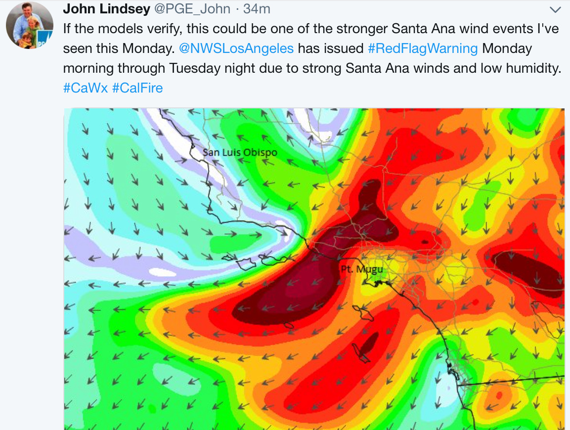
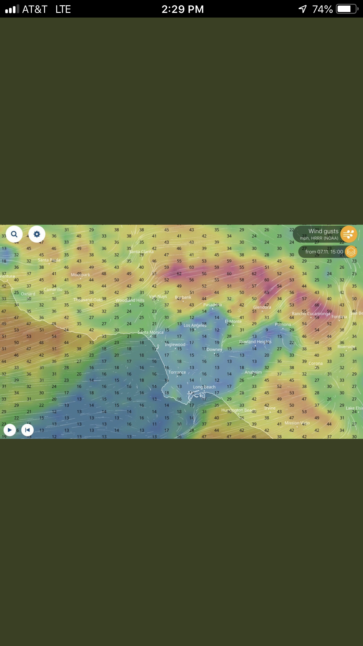
Most areas in So Cal got a pretty good soaking last night. We are still on track for a pretty good Rip the next few days. The moisture will help a great deal, but things will start to dry out with these winds. From the NWS LA:
Offshore surface pressure gradients with the NAM forecasting LAX-DAG down to -7.2 mb at 12Z Mon morning. These strong offshore gradients will also be accompanied with cold air advection and upper level support. 850 MB winds up to 50 kt and 950 mb winds up to 60 kt are predicted by the NAM over portions of VTU/L.A. Counties 12Z-15Z Mon morning. All-in-all it looks like there is the potential for a high wind event at least for the L.A./VTU County mtns with gusts over 60 mph, possibly as high as 70 mph or more over isolated peaks.
3 Likes
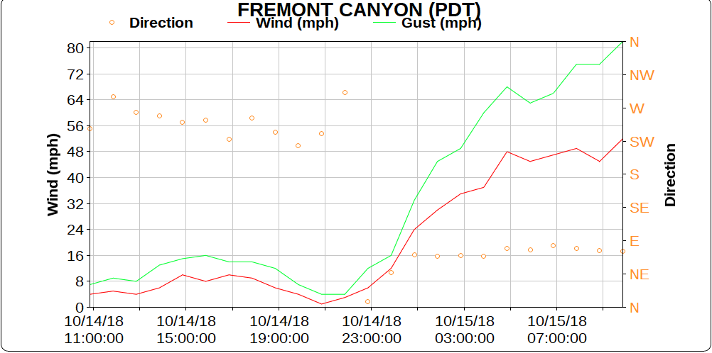
Fremont Canyon - 82 mph
1 Like
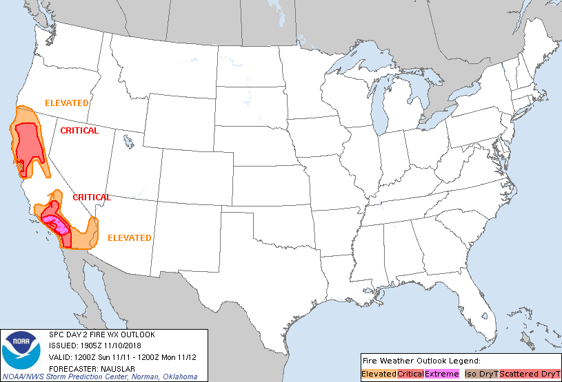
NWS has issued a Fire Weather Watch for Friday and Saturday.
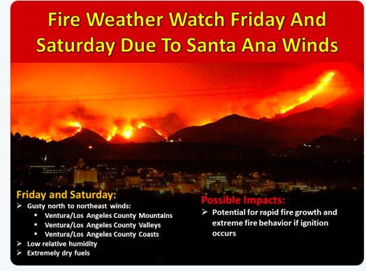
A moderate Santa Ana is forecast Friday through Saturday. Another
upper level trough will cut off over the area, moving to the south
while surface high pressure builds in to the Great Basin. Offshore
pressure gradients will increase Friday-Saturday with northeast to
east winds increasing along and west of the mountains. WRF shows
wind gusts of 30-40 mph through and below passes extending into
the inland valleys, the IE, and through much of Orange County.
Peak gusts of at least 50 mph are expected in wind-prone locales
below passes and canyons.
Good Wednesday afternoon. Just wanted to give another weather update.
For the next couple of days, relatively tranquil weather can be expected for SoCal. Weak offshore flow will prevail through Thursday with some locally gusty northeast winds across the area, especially during the night and morning hours. Along with the weak offshore flow, temperatures will increase while relative humidity remains rather low. So, elevated fire weather conditions can be expected through Thursday.
For Friday and Saturday, it looks like another round of Santa Ana winds for SoCal. At this time, the Santa Ana wind looks to be a weak to moderate event, noticeably weaker than the previous Santa Ana. However, conditions will be warm and dry (and there will be no mitigating effects of any recent precipitation). So, critical Fire Weather Conditions are possible and a FIRE WEATHER WATCH is in effect for Friday and Saturday.
After Saturday, the offshore flow weakens yet again, turning to a more diurnal pattern. So, temperatures will be a bit cooler and relative humidity will be a bit higher.
Stay safe out there!!!
Wx_Guy
2 Likes
For So Cal into next week.
A Santa Ana wind event is likely beginning early next week. Winds are currently predicted to begin Tuesday, with widespread warming and drying, and peak on Wednesday. Additional details on the strength and duration of the event will be provided as forecast confidence increases. After a day or so break, there’s a chance for another Santa Ana event beginning late in the week or at the start of the weekend. Meteorology will continue to monitor both events and issue further information as it becomes available.
2 Likes
Good morning, everyone. Just wanted to give a quick update on the upcoming weather.
Looking at things this morning, the forecast is still pretty much on track. There will be some decent Sundowners across Santa Barbara county (gusts possibly 35-45 MPH) and northerly winds through the I-5 Corridor (gusts possibly 25-35 MPH) Sunday night and Monday night. However, RH will not be dramatically low and will exhibit decent overnight recovery. So, given the current state of the fuels, there will be elevated fire weather concerns during this time period, but widespread critical fire weather conditions do not look likely.
By Tuesday morning, the flow will shift to the northeast and a weak to locally moderate Santa Ana wind event is likely Tuesday and Wednesday (with the strongest winds on Wednesday morning). With this event, RH will be lower with more limited overnight recovery. So, there is a decent chance of Red Flag conditions across the area, especially in the mountains and foothills. Would not be surprised to see a Fire Weather Watch or Red Flag Warning for this time period, although confidence in this possibility is only moderate.
As always, pay attention to the latest forecasts from the NWS and GACC as the strength of these wind events could change from day-to-day.
Stay safe out there.
Wx_Guy
I hope this intel helps you out. Again, there does not appear to be any strong Santa Ana wind event at this time for next week.
5 Likes
This intel is very useful for me, thank you very much for doing the leg work and posting
Good Sunday morning!!! Just a quick weather update to get your week started.
For today through Wednesday, onshore flow will return to SoCal as high pressure aloft weakens. So, a cooling trend can be expected through Wednesday with temperatures dropping to around seasonal normals by Tuesday and Wednesday. Additionally, there will be some coastal stratus/fog developing during the night and morning hours.
For Thursday through next weekend, things could get more “interesting” for SoCal. Both of our main long range computer models are indicating surface high pressure building into the Great Basin on Thursday and Friday. As this develops, Santa Ana wind conditions are likely across the area. At this time, the ECWMF (European) models is noticeably stronger with the offshore pressure gradients, indicating a moderate to strong Santa Ana event. The GFS model is weaker with the offshore gradients, indicating a weak to moderate Santa Ana event. Additionally, as one would expect, these offshore winds will bring much drier conditions to the area with RH dropping into the teens and potentially single digits.
So given the continued critical LFM values, elevated to critical fire weather conditions are likely Thursday through the weekend. At this time, not really confident in the strength of the Santa Ana event for Thursday and Friday, but the potential is there for a significant event.
Please stay tuned to the latest forecasts from the NWS and GACC. As we draw closer to the Thursday/Friday time frame, we will have a much better handle on the potential strength of the event.
Stay safe out there!!!
Wx_Guy
5 Likes
Looks like weak to moderate Santa Ana Thursday and Friday
https://fsapps.nwcg.gov/psp/sawti
With a fire weather watch
https://forecast.weather.gov/showsigwx.php?warnzone=CAZ048&warncounty=CAC065&firewxzone=CAZ248&local_place1=5%20Miles%20W%20March%20AFB/Riverside%20CA&product1=Fire+Weather+Watch&lat=33.9029&lon=-117.3547
1 Like
Red flags now posted for So Cal for a moderate Santa Ana event. Winds could hit 50-60 out of the East. Humidity may drop as low as single digits overnight Thursday into Friday.
1 Like
Just to add on to SIXONENINE’s post…Predictive Services has added our 1st “High Risk” days of the fall for most of So Cal. 4 of the next 5 days look interesting for sure.
https://gacc.nifc.gov/oscc/predictive/outlooks/Scal_Fire_Potential.pdf
1 Like
Red flag warnings issued for the tulare and kern county mountains.
https://forecast.weather.gov/wwamap/wwatxtget.php?cwa=hnx&wwa=red%20flag%20warning
NWS - Los Angeles
FIRE WEATHER…10/214 PM
The latest NAM model has a LAX-DAG pressure gradient of -8.3 on Tuesday morning,
which is the strongest pressure gradient of this round of Santa Anas.
Santa Ana conditions will return tomorrow morning across much of
Los Angeles and Ventura Counties with northeast winds kicking in
around 4 am mountains and inland areas then by around 6 am in the **
** coasts and nearby valleys.
Northeast winds will increase in the
mountains to 25 to 35 mph with gusts to 55 mph and localized gusts
to 60 mph in wind prone passes and canyons. For the valleys and
coastal areas, winds of 15-30 mph and gusts to 45 are likely with
some localized gusts to 55 mph possible. Conditions become more
favorable for strong winds as Sunday morning progresses and into
Sunday afternoon. It`s likely that the period from about 10 am
through 4 pm Sunday will have the most intense period for winds
and very low relative humidities for this event.
By late Tuesday afternoon when the red flag warning is
expected to expire at 5 pm. Overall the confidence in timing for **
** this event is high, with moderate-high confidence on wind speeds,
and high confidence on relative humidity forecasts.
1 Like
You put this in the CNR weather forum, but then quoted the Los Angeles NWS office.
I just look through the NWS site from LA/Oxnard and saw no mention of the -8.3 gradient
This is what I did find from the fire forecast discussion just issued at 215pm
The LAX-DAG offshore gradient will not be as
impressive as we saw the last few days, but the 24 hour trend from
onshore to offshore flow will be enough to drive the winds. This
should be a moderately strong event with some marginal upper level
support Sunday. There will be the potential for local gusts
around 60 mph in the mountains Sunday.
https://www.wrh.noaa.gov/total_forecast/getprod.php?new&prod=XXXAFDLOX&wfo=lox
Regardless of what weather info is being sent out or who is saying it, best to error on the side of caution and plan for the worse. We have several more days of critical weather and many agencies are close to draw down.
Be safe and PACE
2 Likes
From NWS S.D. Office:
.DISCUSSION…FOR EXTREME SOUTHWESTERN CALIFORNIA INCLUDING ORANGE…
SAN DIEGO…WESTERN RIVERSIDE AND SOUTHWESTERN SAN BERNARDINO
COUNTIES…
…A Dangerous Fire Weather Environment will Exist Across **
** Southern California Sunday-Tuesday as a Strong Santa Ana ****
**** develops…
A shortwave trough over the Pacific Northwest will dive southeast
over the Rockies to New Mexico by early Monday. Strong surface
high pressure will build in behind this upper level feature into
the Great Basin tonight-Sunday with pressure rises into Southeast
California and Arizona Monday-Tuesday. This will set up a tight
surface pressure gradient with offshore gradients 10-11 mb San
Diego to Tonopah, Nevada and an impressive 5-7 mb from San Diego
to Imperial. The result will be a strong Santa Ana wind event
developing.
Winds strengthen tonight and become strong from the San
Bernardino and Riverside coastal mountain slopes and passes into
the Inland Empire (especially northern sections) and to the Santa
Ana Mountain coastal slopes in Orange County. The winds will
strenghten further south into San Diego County (coastal mountain
slopes, foothills and inland valleys).
This will be a multi-day, strong Santa Ana Wind event. Fuels are
already at near their driest for this time of year. We have
had bone dry air in place for days and with more consecutive days
of extremely dry air (relative humidities in the single digits)
ahead, this will make for a potentially dangerous situation. The
mix of strong winds in a desert-like airmass would likely lead to
fast spreading wildfires should fires start. The bone dry air is
forecast to spread all the way to the coast by Monday.
2 Likes
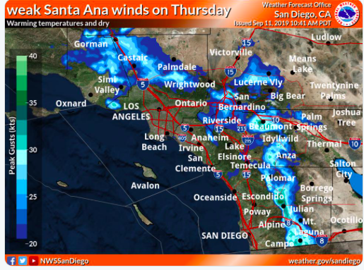
The first Offshore wind event of the Fall starts tomorrow in So Cal. This event will be weak but will cause winds to gust up to 25-30 in favored spots. Potential wind speeds below.
4 Likes