Red Flag announcements have just been made. The trend continues in So Cal.
9 Likes
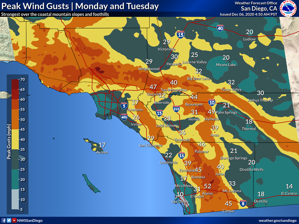
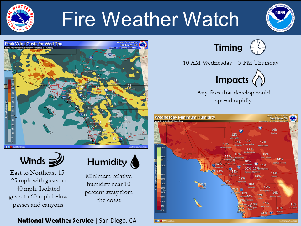
To support the graphics above from Anvilhead see this afternoons AFD from NWS San Diego.
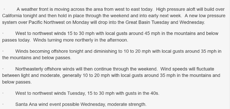
The models this morning are projecting a stronger wind event than previous runs, especially in San Diego County. There is strong upper support with this cold system, with 50 kt 850 mb winds in SoCal associated with the circulation around a cold 561 dm closed upper low that stalls out west of northern Baja Tuesday morning. These east winds will crest the mountain ridges and flow down the western slopes into the foothills and eastern valleys. Based on the recent data, wind gusts to 70 mph are possible in the back county, especially in the east-west transverse ranges of San Diego and Riverside Counties. In collaboration with Oxnard and others, a High Wind Watch was issued for the mountains due to the elevated threat for high winds. The watch runs from Noon Monday to Noon Tuesday in the SBD and ORA County mtns, and from 6 PM Monday to 6 PM Tuesday for RIV and SAN County mtns.
5 Likes
Forecast on track. Rare backdoor cut off low pressure system will move into the area tonight. The latest NAM-WRF 00z run peaks offshore gradients at -8.2 (LAX-DAG) from the east and -6.3 (LAX-BFL) from the north on Tuesday morning. The average peak gradient would be around -7.2 which is very strong. Even adjusting downward on the peak gradient as the NAM tends to overdo gradients by .5 mb to 1 mb its a critical offshore gradient.
The LAX-TPH (Tonopah, Utah) gradients peaks at -14.1 which indicates some cold air advection to drive those winds into the valleys, and upper level support appears good.
There is really good potential for widespread winds, adding to the fire danger as areas that typically do not receive strong winds could.
17 Likes
Good morning. LAX-DAG gradients peaked at -7.5, LAX-BFL -7.5, and LAX-TPH at -17.4. This was a moderate to strong Santa Ana wind event that will wind down through Wednesday.
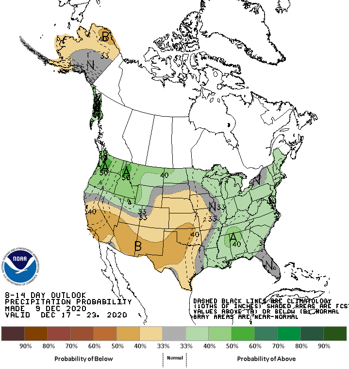
The forecast philosophy for the extended period is there is no rain forecasted in the next 7 days. The forecast models bring in a gigantic long wave trough across the entire United States besides Southern CA.
On Friday a trough will sharpen across AZ. The GFS is progressive with the trough however the EC is sharper. This trough will likely bring in a moderate-strong Sundowner wind event across the SB front country. The details will be worked out. The sharper EC would bring a weak Santa Ana wind event on Saturday-Sunday
The pattern will likely become less amplified, so less of a N-S oriented ridge. As typical on a 10-12 day cycle, there should be reamplification of the pattern around 12-20 which should bring us either rain or another strong Santa Ana wind event.
With no rain in the forecast and dry conditions expected by the Storm Prediction Center through at least the 25th, the threat is high that this could be the driest December in Southern California history.
12/9 Evening Update
There is now growing model support for a long duration of Santa Ana winds next week. After the passage of this weekends trough, the long wave trough sharpens across the four corners region next week. Several shortwaves rotate around this trough next week adding upper level support. These conditions remind me of the conditions during the Thomas Fire. Several weeks of offshore flow occurred. When the flow was not out of the NE, it shifted to a sundowner condition out of the N as impulses rotated around the long wave trough. At present, I’d like to see a sharper trough axis across the desert SW before speculating that winds could become strong, but the sypnotic set up is definitely there should that occur.
From NWS San Diego Area Forecast Discussion
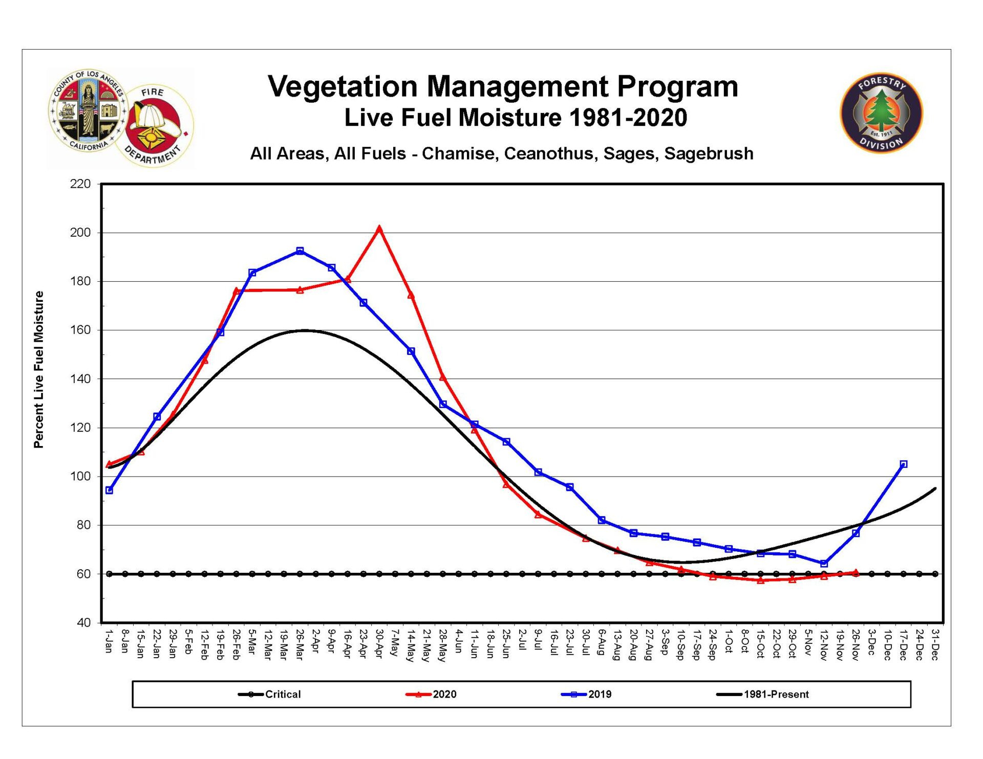
Fuel moisture levels are already critical across Southern CA. The next duration of offshore flow will annihilate any remaining live fuels.
7 Likes
Just a hair over .75 here in Twain Harte. It was a good soaking rain. In early October we got 1.75 in a storm. Drove over Hwy 88 and not much snow over the passes that was last Monday. Kid was on four acres on the STF on Wednesday. So with the up coming storm tomorrow and the one we just had hopefully the storm door will stay open. Damn, we need it!!!
5 Likes
Moderate sundowner wind event tonight through Tuesday morning, but RH will stay pretty high as moisture filters over the Northern ranges.
Still watching the 12-20-12-23 time period.
The 12z GFS brings in a bizarre outside sliding cut off low simultaneously with a deep trough and subsequent strong surface high pressure across the Great Basin… with a ridge building above eastern CA… truly a bizarre set up. This type of scenario could bring a strong offshore wind event if the disturbance sets up in the right position. After this, another trough dives across the Great Basin and picks up the cut off low, setting up continued strong offshore winds. The ECMWF is trending towards a wet solution. The ensembles means of the CMC, EC, AND GFS, show a Santa Ana signal.
The exact details this far out is hogwash, but with the pattern reamplifying the chance remains for our first rain of the year or a strong offshore wind event.
With the NW flow bringing in hybrid continental low pressure systems across CA’s breadbasket, fire season north of Grapevine, CA is all but over.

8 Likes
Continuing to monitor the same time frame. 20th-25th.
Forecast models continue to struggle with the exact placement of a cold, large trough of low pressure. Recent runs have began to come to a consensus that the axis will move into eastern Nevada. This is not that optimal for cold air advection and upper level support. A ridge will build overhead at the same time so gradients will be pretty impressive.
The GFS peaks LAX-DAG gradients at -8 with an -11.9 24 hour trend. Without the upper support and cold air advection this will only be a wind advisory type event for the mountains and below wind advisory threshold in most other places.
South Ops take:
12/19 quick hit
NAM placement of the trough brings in a moderate-strong Santa Ana wind event. LAX-DAG gradients likely peak in the -8 to -8.5 range. LAX-BFL in the -5 range. The GFS continues to be less bullish with this trough axis.
I have provided a comparison of the trough axis placement between the NAM and GFS model runs tonight.
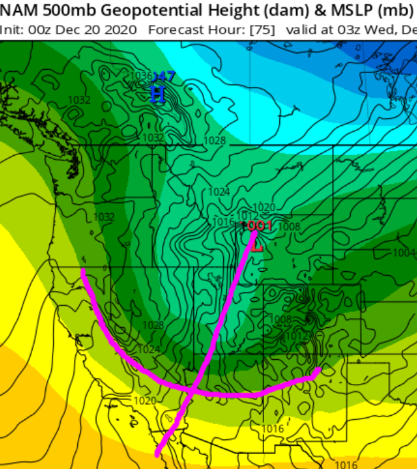
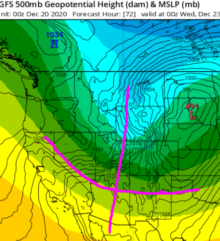
The other suites of models trend more towards a solid moderate Santa Ana wind event, with a more aggressive and sharp trough over AZ. The forecast is biased towards this and not as much the GFS.
At the end of the month… models develop a rare surface low off of the northern CA coast. The exact placement of this development will largely dictate if we get precipitation, or if the trough just slogs on by to the north.
4 Likes
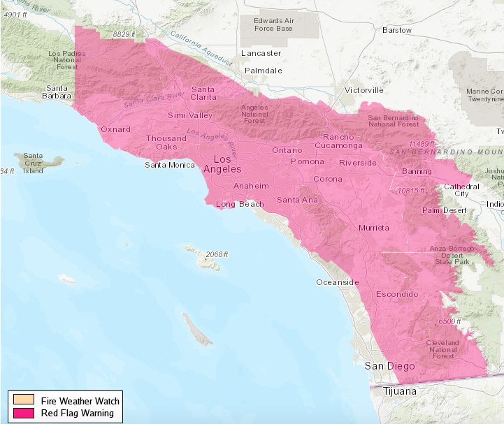
NWS LA - Wed: The reason the Santa Ana will be peaking this afternoon than the typical morning hours, is due to a strong surface low which strengthens to 1041 MB high across Nrn Nevada behind a passing (inside slider) trough headed to the plains. This will cause the gradients to strengthen to around -8MB by this evening. Confidence is high with the strengthening Santa Ana winds and significant drying by late this morning into tonight gusts of 40 to 60 mph across wind favored areas. Humidity levels are expected to fall to around 15 percent by mid morning today across downslope areas, with widespread drying to between 3 and 10 percent this afternoon into Thursday morning. An approaching upper level low pressure system is also expected to help induce east to southeast winds gusting 25 to 40 mph (strongest across higher terrain) with associated dry air across portions of San Luis Obispo and Santa Barbara counties, leading to some elevated to brief critical fire weather conditions tonight in those areas.
Critical fire weather conditions combined with very dry fuels has resulted in the upgrade to a Red Flag Warning for Los Angeles and Ventura counties. This will bring the the potential for rapid fire spread, long range spotting, and extreme fire behavior with any new fire ignitions.
8 Likes
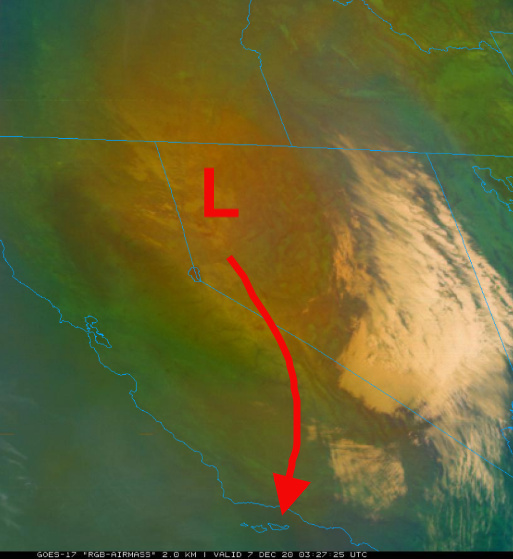
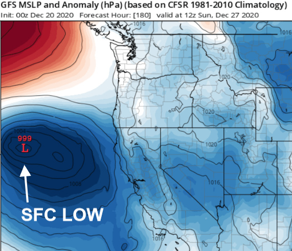
A rare surface low pressure is going to develop along the Central coast Sunday PM into Monday which will enhance rainfall on the southern side of it along the SB/SLO coastal slopes.
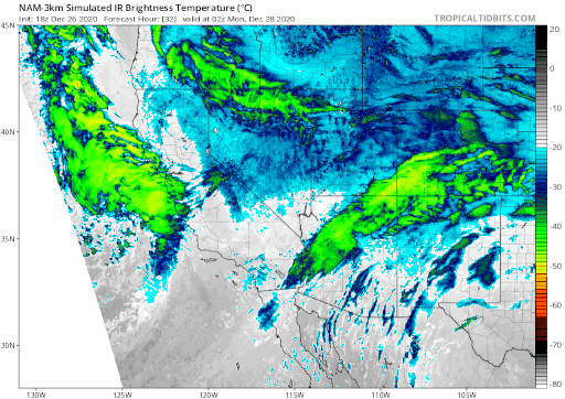
Surface low showing on simulated satellite
The deep layered trough should help produce decent rainfall across the entire South Ops with snow levels down to 3,500 feet in the north and 4,500 in the south, except locally down to 3,000 feet in the Antelope Valley.
The trough axis moves all the way into central Mexico  A low pressure system, with a blast of cold continental air swings down the western side of it on New Years into the second. This would set up either a backdoor cold front and/or Santa Ana wind event with excellent upper level support. Ridging builds in from the pacific through the first few days of 2021 and rising heights will leads to continued offshore gradient trends.
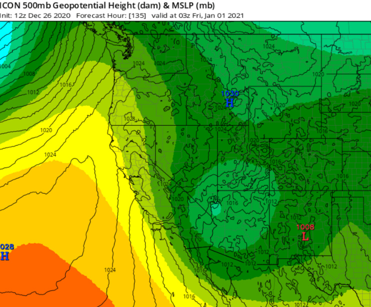
backdoor cold front
Fuels moisture levels will not respond to precipitation right away so the threat is still there for wind driven fires.
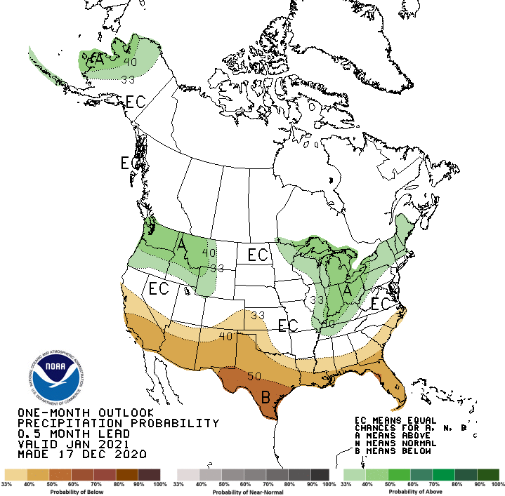
The climate prediction center favors drier than average weather for South Ops in January 2021
6 Likes