Complicated forecast for tomorrow and Wednesday.
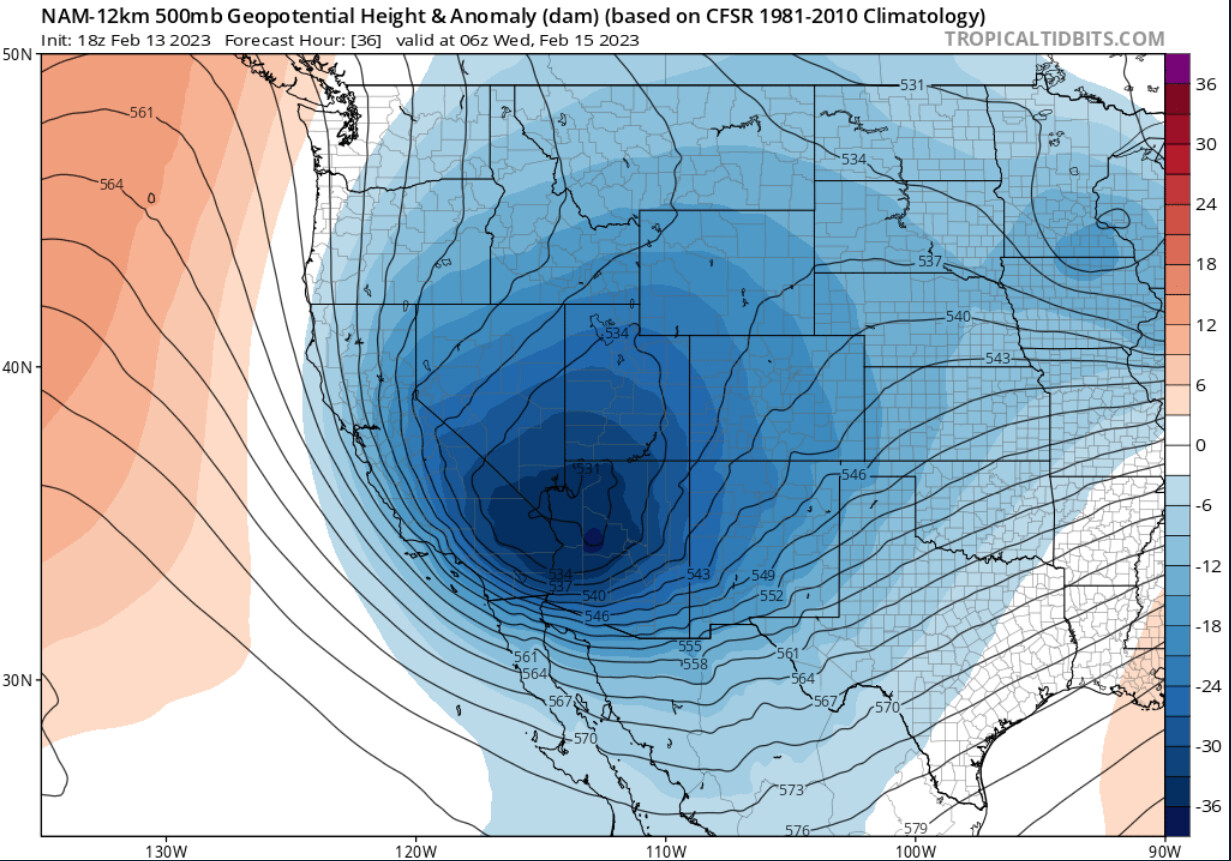
Latest NAM-WRF models have shifted an extremely cold upper level low further to the west on the latest model run. The further west shift of the cold core makes a difference in that it could set up enhanced mountain wave event on the San Gabriel mountains and surrounding valleys that results in damaging winds. Models will struggle to show this type of wind event due to the extreme rarity of this type of arctic upper level low at this part of the world.
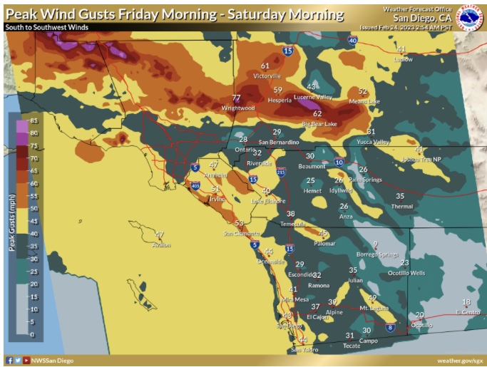
If the low shifts a bit further west and south as suggested with the latest NAM model runs it would set up a secondary classic Santa Ana wind event. It is worth noting the hazards of strong N-NW winds with gusts in excess of 90 MPH in some favored mountain areas, and widespread wind gusts of 40-50 MPH across Southern CA if the low materializes. The very low dew points would suggest that any precipitation that falls through the column will make it to the surface as snow above 1,500’, even if the wind is bumping up surface temperatures.
Here is a comparison of the 12-1-11 mountain wave event in the San Gabriel valleys
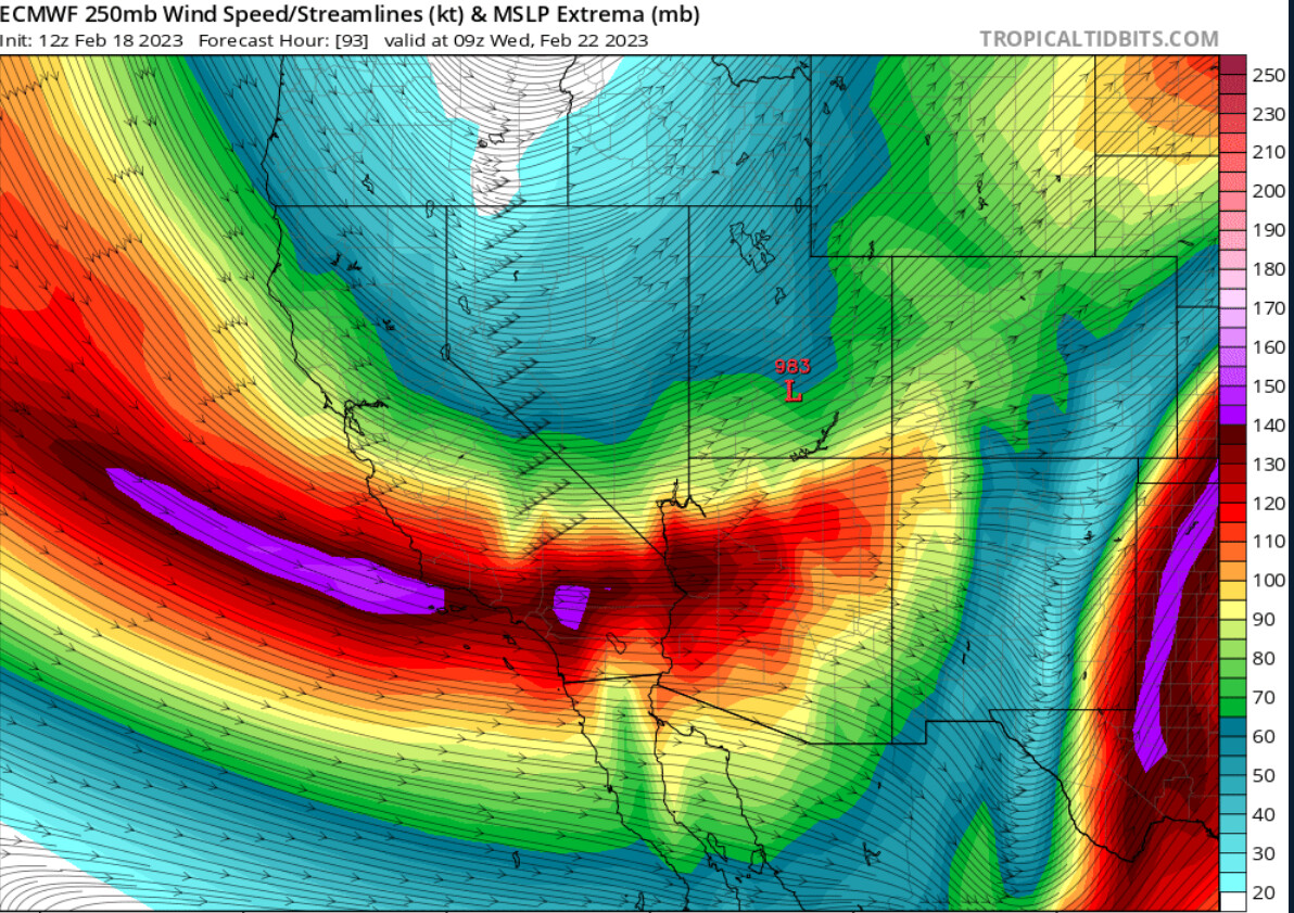
A powerful jet of 170 knots is likely to move across Southern California Wednesday. This would produce very strong winds across much of the area. We are starting to get into the window of the high resolution models, so it will be interesting to see just how strong the winds could be. The often exaggerated ICON model produces max gusts of over 120 MPH over the mountain crests.
ECMWF 250mb wind
The jet set up directly over the region coupled with a large height gradient would bring widespread strong winds across the area. This storm is more powerful than the previous storm we experience last week.
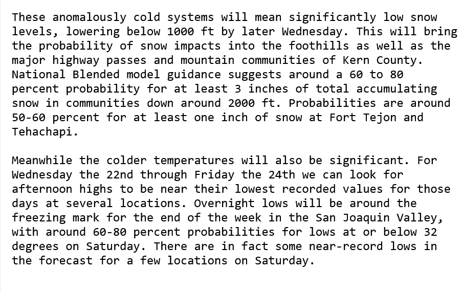
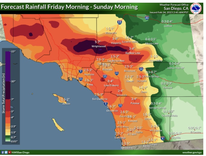
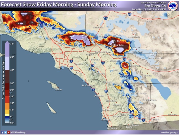
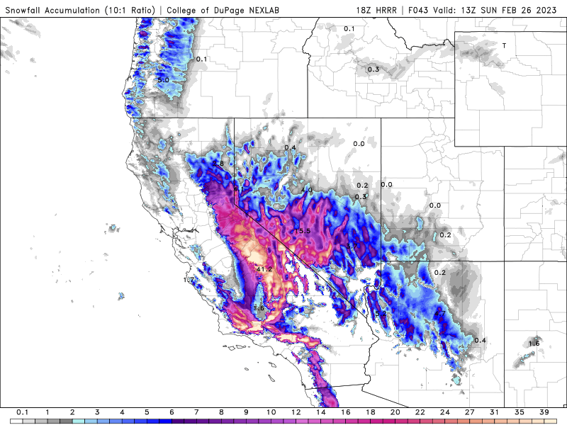
This initial trough is going to bring in a very cold air mass, but with limited moisture. The snow level could fall to less than 1,500’ with the first trough, and snow could fall through the column if there is enough moisture. A second trough is forecasted to pivot around the first trough, bringing more moisture and a reinforcing shot of cold air from the entrenched airmass… This is where things will get interesting. If the models continue to show heights being as low as they are for these storms, most of the precipitation for the second trough would fall as snow above 1,000’. The ECMWF, CMC, and ICON models are quite bullish with snowfall currently… with many locations above 1,500’ receiving accumulating snowfall that would significantly impact the region. The GFS is way more conservative, with the coldest air and moisture staying further north. If we are compromising in the middle and being conservative currently, it looks like there will be accumulating snowfall above 2,000’ with more than 3" possible above 2,500’.
Per NWS Los Angeles, this is the first ever Blizzard warning in LA County history.
Another point I will highlight… if the snow event manifests itself and the third upper level low takes the forecasted track the following could happen for Saturday night and early Sunday: low level flow around the upper level low could drop snow levels very low again for accumulating snowfall below 2,500’ or lower again.
An additional upper level low is poised to move through CA around Tuesday of next week, there is disagreement in the exact placement and upper level heights but it should be watched as with the presence of extensive snow cover it should not be difficult to continue very low snow levels or even freezing rain in the warm sector.
Midwest style occluded low pressure / cold front moving into South Ops!
-5% risk of damaging winds with the frontal boundary
-2% risk of landfalling waterspouts/quick spin up tornadoes
-WPC issued blizzard products for excessive snowfall: Storm Prediction Center Mesoscale Discussion 188
-High risk of excessive rainfall
HRRR is suggesting that the San Joaquin Valley will remain more insulated from the warm air advection, and that a post cold front environment of moisture moving over very low dew points could produce snowfall on the valley floor.
Update: Snowing in Paso Robles at 750 feet
https://cwwp2.dot.ca.gov/vm/loc/d5/us101springstreetsouthboundexit.htm
Also snowing in Bakersfield at 700 feet.
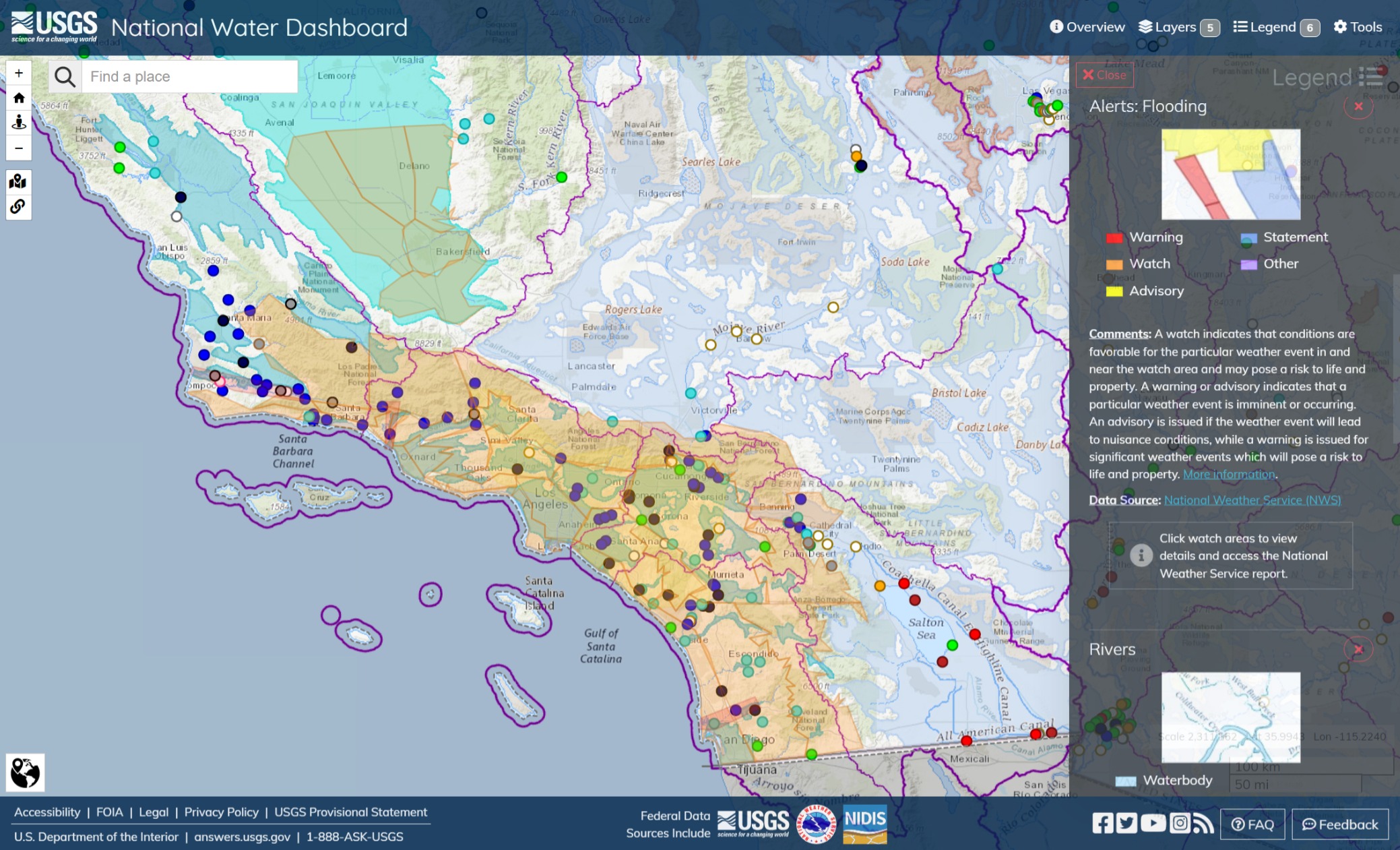
The Santa Ynez River is in Minor flood stage. The 2021 Alisal Fire scar and the coastal slope of the Santa Ynez Range are under various stages of evacuation alert watches. The Ventura River is flowing over the banks, along with flooding along the San Diego River, west of El Capitan, from Los Coches Creek to Mission Bay.
A couple swift water rescue incidents at Hansen Dam near Burbank involving two LACoFD AW-139s.