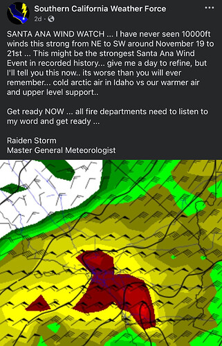
Hearing conflicting info of a record breaking Santa Ana possibly for San Diego/So Cal next week. The Intel shows many different predictions
Funny you bring this up…
I was talking to one of the IMETs today. He says he was 50/50 this morning.
Either a weak to moderate OR a record breaker.
He thinks everything depends on what happens in the gulf,
I guess time will tell.
Stay Safe!
This guy has been pretty accurate with over the years I’ve followed him.It will be interesting to see his detailed report when he posts it
That guy is a loose cannon with no training as a meteorologist. He has been visited by the FBI for making threats against the NWS.
Best to bet on official sources.
But he rarely misses on his forecast’s. His long term predictions are pretty incredible.
The NWS Los Angeles forecast discussion from this morning (excluding some of the synoptic-scale stuff):
…CRITICAL FIRE-WEATHER EVENT INCLUDING HIGH-END RED FLAG CONDITIONS FROM A MODERATE TO STRONG SANTA ANA WIND EVENT BECOMING INCREASINGLY LIKELY FOR NEXT TUESDAY THROUGH WEDNESDAY…
By next Tuesday and Wednesday, a moderate to perhaps strong Santa Ana wind event is expected to develop. This will bring an increasing likelihood for critical fire-weather conditions including HIGH-END RED FLAG conditions.
In response to these developments, the next Tuesday through Wednesday event will likely be a warmer and drier Santa Ana wind event compared to the event from last week. Relative humidities may be 5% drier over the coastal slopes and valleys for next Tuesday through Wednesday – with widespread lower to middle single digit relative humidities possible – as temperatures warm well into the 70s and 80s (enhancing the fire-plume growth- potential component). With LAX-Daggett offshore pressure gradients reaching the 6-8 mb range, strong winds are expected to focus over the mountains and foothills of Los Angeles County through the Ventura County Mountains including the Santa Susanas and extend over coastal slopes through the coastal valleys and over the Santa Monicas to the beaches – i.e., Santa Ana wind-prone areas.
One notable difference between the next Tuesday through Wednesday event compared to the event from last week is that the stronger upper support for next Tuesday through Wednesday should be displaced much farther east, owing to the synoptic-scale interactions discussed above. As a result, present indications are that winds will not be quite as extreme for next Tuesday through Wednesday (modestly reducing the extent of long-range spotting potential). Nevertheless, strong winds are anticipated next Tuesday through Wednesday, and there is a greater than 80% chance that fire-weather headlines will become necessary across much of Los Angeles and Ventura Counties for Tuesday through Wednesday of next week. With very poor overnight relative humidity recovery expected, this will have the potential to be a long- duration Red Flag event, adding to the potentially very favorable fire-weather environment for large fire development.
While elevated to perhaps critical fire-weather conditions may last into next Thursday-- and this type of pattern does usually draw out such conditions on the later side – present indications are that winds should begin tapering off by the end of next week while very dry conditions continue. Also of note, spotty elevated fire-weather conditions cannot be ruled out over the interior mountains of Santa Barbara and San Luis Obispo Counties next week, though the focus for stronger winds will be in Los Angeles and Ventura Counties.
I’ve followed this guy in Arizona for two years now. He rarely misses! His prognosis has been on the money more times than not. When all the other national weather forecasters have predicted something completely, Raiden, when he makes a different prediction is about 95% or so in my book. He’s also been right during fire season here in Arizona. Yes, he’s not liked by most in the professional ranks of prognosticators and they talk crap about him and down talk him all the time. I will tell you this though, results are what I look for and Raiden has a far better record in predicting the weather. Maybe that’s why they hate him so much! He’s a hoot though on his podcasts, facebook.
Well, I hope everyone is wrong! Really don’t want to see the south land on fire before the Holidays.
You too can celebrate Thanksgiving with hundreds of fellow friends at base camp.Pan ahead to get your Xmas pictures with Smokey and Captian Cal!
Been there, done it and literally got the t-shirt.
Man remember spending Thanksgiving in SLU with Rednose?
We ran a few fires too.
The SAWTI isn’t showing any threat for next week. Looks like So Cal is going to catch a break
So much for the super Santa Ana huh?
I believe he said: “Strongest Santa Ana Wind Event in recorded history… Get ready NOW … all fire departments need to listen to my word and get ready …”
I expected more from a Master General Meteorologist. 
This was just one of his pretty accurate rarely missed forecasts.
I don’t facebook, but I’m guessing the previous referenced post has been deleted by this cl*wn as he does on all his inaccurate predictions.
Trust an IMET over social media.
Weird that he shut down commenting on the FB post.
He also predicted widespread tornadoes in AZ last summer. Guess what happened?
Not schilling for the guy, but we did have a tornado in Az. when he predicted that.

