CAL FIRE IMT 3 (See), is being activated for this incident
9 Likes
Frequencies assigned today:
Air Tactics FM 167.950
Air Ground 159.270 t192.8 (cdf tac15)
Victors assigned 123.175, 133.225 123.025 (TOLC)
3 Likes
CalTopo has it mapped. Can zoom in.
https://caltopo.com/map.html#ll=38.31579,-120.56602&z=11&b=t&o=f16a%2Cr&n=1,0.25&a=mba%2Cfire%2Cmodis_mp
GOES17 is being blocked a bit by the cloud cover, which could be helping moisture recovery.
https://rammb-slider.cira.colostate.edu/?sat=goes-17&sec=conus&x=7649.25&y=3679.875&z=6&angle=0&im=18&ts=1&st=0&et=0&speed=130&motion=loop&maps[borders]=white&lat=0&p[0]=cira_natural_fire_color&opacity[0]=1&pause=0&slider=-1&hide_controls=0&mouse_draw=0&follow_feature=0&follow_hide=0&s=rammb-slider&draw_color=FFD700&draw_width=6
Mt. Zion RAWS:
80% RH
63 Air Temp
4mph winds out of NW
13% moisture on 10 hr. fuel stick. That’s a big change from yesterdays low of 5%.
EDIT UPDATE RAWS: 15:00
RH down to 43%
Air temp 80
11mph winds out of the west
5% on 10 hr fuel stick, dried out quick.
9 Likes
— Objective is to keep the #ElectraFire east of Highway 49, south of Highway 88, north of Jesus Maria Road, and west of Highway 26 and Railroad Flat Road.
— Continued threat to critical power infrastructure
— 1,225 total personnel assigned
MODIS/VIIRS satellite heat detection for #ElectraFire SE of Sutter Creek, CA. Data always at least 3 hours old, locations approximate, sometimes false positive. Never rely on this data to ignore an evac order! #CAfire #CAwx
Open #GISsurfer map: bit.ly/3yk9zjC
9 Likes
A post was merged into an existing topic: CA-AEU Electra???
4 posts were merged into an existing topic: CA-AEU-Electra???
KCRA back up live.
5 Likes
KCRA is back

1 Like
CALFIRE Team 3 taking the fire today at 0700.
4 Likes
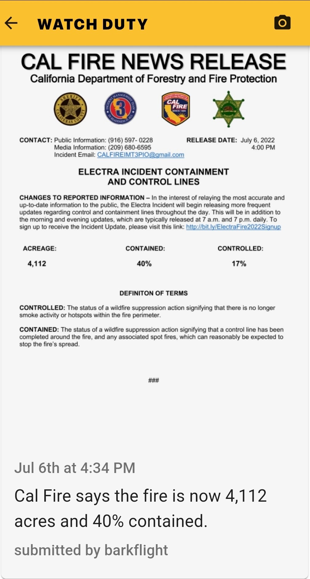
I can’t post any updated maps but here is the latest from CALFIRE as of 0757hrs today:
3900 acres, 10% containment
5 Likes
4 posts were merged into an existing topic: CA-AEU-Electra???
It’s on the press release from Cal Fire this evening.
3 Likes
Press release that I can’t post due to the server issue right now
2 Likes
#ElectraFire (Amador & Calaveras Co) - There are firing ops going on in Divisions J & K since 1pm & they are continuing into the evening + tomorrow. Bringing fire down to the river & trying to close the gap for it to spread northwards. So far this has been extremely successful.
#ElectraFire (Amador & Calaveras Co) - The second area of concern is Division U. Today they have also been & continue to conduct firing operations near the Division U & V break. No surprises in any of the operations today. Winds: down canyon at night, up canyon in the day.
From CAfirescanner on Twitter
5 Likes
HelCo as they were departing: Div F looking good. Some heat near the line in Div H from dirty burns. Div J firing ops went well w/ good consumption, couple of spots across but all picked up. Div U firing op is held up. No activity in Divs A, C, V, W, X.
7 Likes
Per this mornings 209: 4272 acres, 40% Containment, (2441 acres are in Amador County and 1712 acres are in Calaveras County).
1886 Personnel Assigned.
No structures damaged or destroyed to date.
Objectives: Keep the fire North of Jesus Maria Road, Keep the fire South of Highway 88, Keep the fire East of Highway 49, Keep the fire West of Highway 26/Railroad Flat Road.
Current Ops IR MAP (Resized for mobile/web friendliness):

10 Likes
Last night CalFire used one of their new fire hawks for night water drops for the first time:
11 Likes