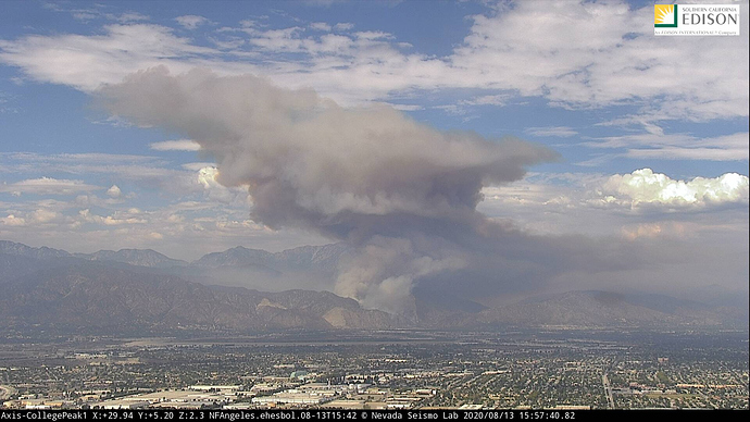
State ID: CA
3 letter designator: ANF
Fire name: Ranch
Location: N San Gabriel Canyon Rd x N Ranch Rd; Azusa, CA
Reported acres: 5
Rate of spread: rapid
Report on Conditions: started in the riverbed, now running uphill towards structures in medium to heavy fuels.
Structure threat: yes
Resources: ANF, 2nd alarm, LAC, Verdugo, AA310
Hazards: Steep terrain
Weather: Excessive heat warning
Radio channels: Admin LAC Blue 6, Cmd V-4, Tac: V-13 and V-12, LAC A/G and Vic 130.700
Scanner link: https://www.broadcastify.com/webPlayer/22924
Webcam link: http://www.alertwildfire.org/orangecoca/index.html?camera=Axis-WilsonEast&v=81e002f
http://www.alertwildfire.org/orangecoca/index.html?camera=Axis-College1&v=81e002f
http://www.alertwildfire.org/orangecoca/index.html?camera=Axis-Sunset2&v=81e002f
http://www.alertwildfire.org/orangecoca/index.html?camera=Axis-MaddockCanyon&v=81e002f
Live Video: https://abc7.com/watch/23343/
https://www.facebook.com/ktla5/videos/246308759691349/
Agency Website:
New start San Gabriel Canyon, LAC 97’s, San Gabriel Canyon and Ranch Road, 1-2 acres running uphill. Full LAC brush en route. This may be an ANF incident. Name still TBD and LAC helco requesting first alarms with fixed wing. ANF is NOT sending any aircraft, just ground resources. Helco requesting state air assets. Another fire nearby in West Covina as well. Resources stretched again.
Map: https://goo.gl/maps/1Kz5NvbrzT7Um4nn9
LAC asking for a 2nd with structure threat. SRA moving into FRA.
EDIT: ANF is now requesting fixed wing.
20 acres, rapid rate of spread, potential for 200+
ABC7 has coverage with really annoying feedback
LAFD has assigned one helicopter ‘Fire 2’.
The fire is moving into ANF.
Com Plan admin LAC Blue 6, Cmd V-4, tacs V-13 and V-12, LAC A/G and Vic 130.700
This thing just went BOOM, not looking good.
http://www.alertwildfire.org/orangecoca/index.html?camera=Axis-College1&v=81e004f
Has a great view of it now
AA 310 just now arriving
Just confirmed what it seemed like to me, is that it will bump into the Dam Fire containment lines.
Buffer on north side will be the Dam Fire scar. Dozer lines in place. Ember cast is all the way up to Morris Dam from this fire though. Oh, and MAFFS on scene.
Someone flying a drone near the dip site.
Rough mapping estimate and one estimate including fire history. Map is for discussion and not for tactical decision making. Gathered from imagery and helicopter view.
https://caltopo.com/p/6K0K (w/o fire history)
https://caltopo.com/p/4R7H (w/ fire history)
https://caltopo.com/p/4U72 (fire with ownership)
Looks right Shrek. Much appreciated.
16 posts were split to a new topic: CA-ANF-Ranch Pyrocumulus Cloud Photos
looks like it reached fish creek drainage on the live feed.
2016 Fish fire should help limit spread to the West, 2016 Reservoir fire to east and San Gabriel Road to the South . Biggest concern is no recent fire history in Roberts Canyon going north. This puts everything in “Alignment” for a fuels and topographic driven fire. The fire has about 5700 acres of heavy decadent fuel to drive it up the drainage.
Earlier: ANF engines up along the north dozer line said fire bumped line and was holding.
Just now: 3 Tankers released per AA
19:50 AA states all rotor wing off fire.
-2 Night aircraft requested
20:30 The ANF engine patrolling to the north west end of dozer line states
the heavy fuels and intense fire activity worried the line might not hold on this end.
They had a flat duel and were limping out for repairs. Would not be able to monitor
the north west flank. No div. letter had yet been assigned.
