Looks right Shrek. Much appreciated.
looks like it reached fish creek drainage on the live feed.
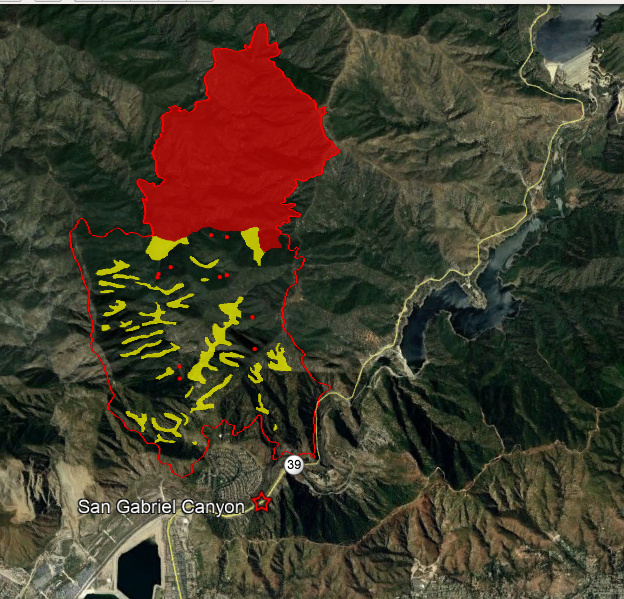
2016 Fish fire should help limit spread to the West, 2016 Reservoir fire to east and San Gabriel Road to the South . Biggest concern is no recent fire history in Roberts Canyon going north. This puts everything in “Alignment” for a fuels and topographic driven fire. The fire has about 5700 acres of heavy decadent fuel to drive it up the drainage.
Earlier: ANF engines up along the north dozer line said fire bumped line and was holding.
Just now: 3 Tankers released per AA
19:50 AA states all rotor wing off fire.
-2 Night aircraft requested
20:30 The ANF engine patrolling to the north west end of dozer line states
the heavy fuels and intense fire activity worried the line might not hold on this end.
They had a flat duel and were limping out for repairs. Would not be able to monitor
the north west flank. No div. letter had yet been assigned.
CIIMT 11 (So Cal Team 1) assigned, in-brief 1630.
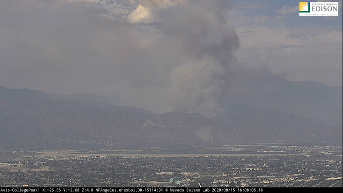
Collgee Peak timelapse paints a good pic too: http://www.alertwildfire.org/orangecoca/index.html?camera=Axis-College1&v=81e004f
Picked up a good head of steam this afternoon. I am wondering if it dropped into Fish Canyon. Had some winds across the front country a bit ago. Had standing wave clouds on the crest for a bit as well (winds aloft) and wonder if it punched a hole in some line on the left flank. San Gabriel River drainage is a great up canyon funnel, and the highest precip in all of LA County is Mt Islip at the top of the drainage due to that flow.
They didn’t get 912, it’s heading north passing over NAS Lemoore.
Off to the Loyalton fire…
All aircraft grounded due to drones in the area.
Still no update since this morning.
Mod NOTE: I moved most, not all, of the Ranch Fire Pyrocumulus cloud photos here: Ranch Fire Pyro Cloud Photos
They provide tremendous insight into the fire behavior on the ground, Situational Awareness, and how widespread this fire is visible. It is my hope that people will continue to provide this level of documentation and update. Additionally, just as the fire complexity is expanding, so too is the complexity of keeping the threads aligned with the spirit and intent of original thread.
Along those same lines, I also deleted a number of posts that were bordering on bickering. This site is dedicated to the integrity and value of each member, their input, and insight. Bickering takes away all of those things and detracts from the mission of this site. Let’s all take a moment and breathe, it’s been a very hectic day with a ton of new as well as continuing incidents and a lot of information about each and every one.
I absolutely agree the bickering is in no way helpful. I can see the humor in anything (much to my wifes dismay) and was merely commenting on the irony of the timing of said pics.
That being said, I truly appreciate all of those pictures, and keep am coming! It absolutely speaks to the fire behavior, and they are just beautiful pics in general.
Carry on, stay safe, and LCES! This next week will be a tiring and trying one.
Thanks for the post. No mapping on Inciweb or Firemappers. This helps.
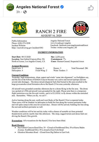
From Inciweb this morning: Yesterday, high temperatures, slope, aspect and winds “came into alignment”, as firefighters say, and the fire at the bottom of Roberts Canyon became very active and moved upslope and into several side drainages. The dense mixed-chaparral fuels that burned in this area resulted in the large pyrocumulus cloud formation above the Ranch 2 Fire area yesterday afternoon.
All aircraft were grounded yesterday afternoon due to a drone flying in the fire area. The drone was spotted at 6 PM and aircraft were grounded for the night. Please note there is a temporary flight restriction over the fire and vicinity, and it is ILLEGAL to fly drones within the restricted area. Remember, “When you fly, we can’t”.
Active burning along the east, north and west flanks of the Ranch 2 Fire is expected today. Three crews will be shuttled via helicopter to build fire line along the western perimeter today and will spike camp in this area for several days. Dozers will be actively building fire line along the east and northern perimeter as well.
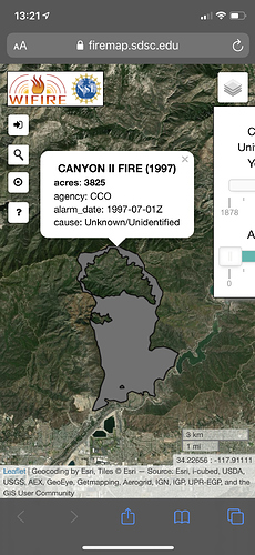
Looking thru past years of fire history, this fire seems to be similar to the 1997 Canyon II Fire. Per the map and an old article, it sounds like they burned along the tops of the ridge lines on the west, north, and east sides to eventually get containment. From avilheads map and muni_caps inciweb update it sounds like they will be able to repeat history on this if everything goes to plan.
Screenshot of the Canyon ll Fire.
Fire is making a substantial push right now…


