Several ST’s were already committed to fires up north. Boone had several. Releasing them for all 3 in SOPs fires
3 Likes
2 Likes
Rainbow STA headed up this morning.
XLF 1321A: LOB STEN & STEN-T, LOB E3, LOB E10, LOB E13, DNY E63, SFS E-821.
3 Likes
34,282 acres
3 Likes
Local news (ABC7) reporting an arrest
2 Likes
6 Likes
2 Likes
A few other outlets (though it’s the New York Post and similar, so not exactly bastions of competent journalism so grain of salt etc.) have sourced a photo of the the arrested suspect from this linked in for their articles:
5 Likes
Anyone have a link for IAP/ MAPS
2 Likes
Doesn’t seem to have the same energy production this morning at it did yesterday based on camera views. Hopefully they can pick it up 
5 Likes
From the SB SO press conference reporting Cal Fire Law Enforcement officers were in the area of the Line fire shortly after the initial dispatch, and used the initial cause and origin determination, plus the review of license plate reader cameras to identify a suspect vehicle and a suspect in the investigation of the cause of the fire. Deputies from the Highland SB Sheriff’s station assisted in the service of a search warrant for his home and vehicle, which turned up evidence supporting his arrest Sept 10th. He has been booked into the West Valley Detention center and an enhancement of “no bail” was granted this morning. The LE investigation reports will be now be turned over to the SB County District Attorney’s office for followup. He may also be a suspect in other earlier fires.
24 Likes
Air is clearing out and activity is picking up on the east side
5 Likes
Do you know how far it’s advanced this morning into the drainage?
Good news there is probably more resources coming into camp today to help. And resources they probably can use in camp if needed. IAP looked skinny this morning.
2 Likes
https://www.instagram.com/p/C_yjtVRSxLE/?igsh=MWQ1ZGUxMzBkMA==
Official mug shot
4 Likes
@fyre Judging by the panorama view on Keller, and the angle on the map its near the mouth of bear creek and looks like it’s picking up some steam below lookout point. WD shows a similar perimeter
2 Likes
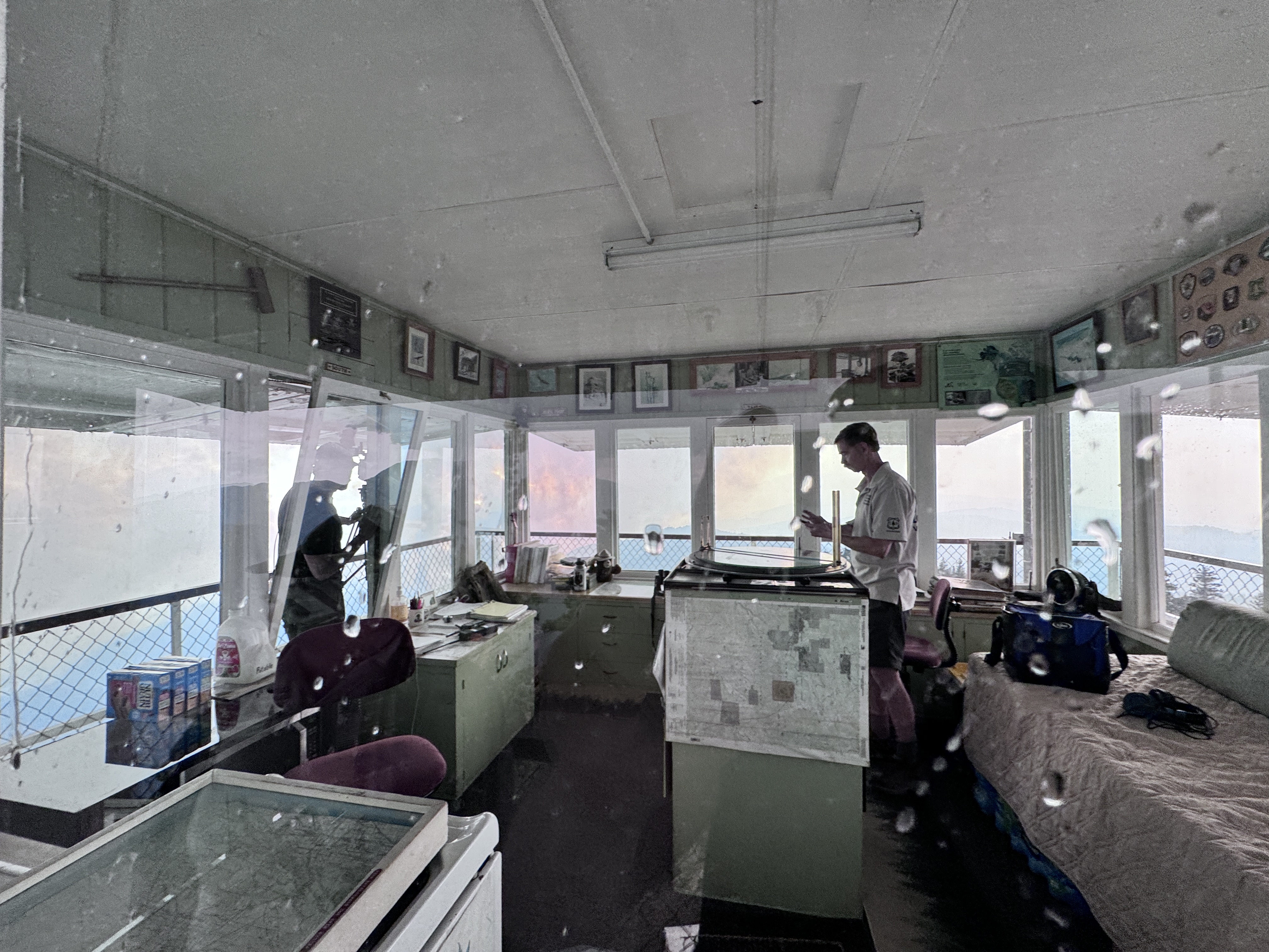
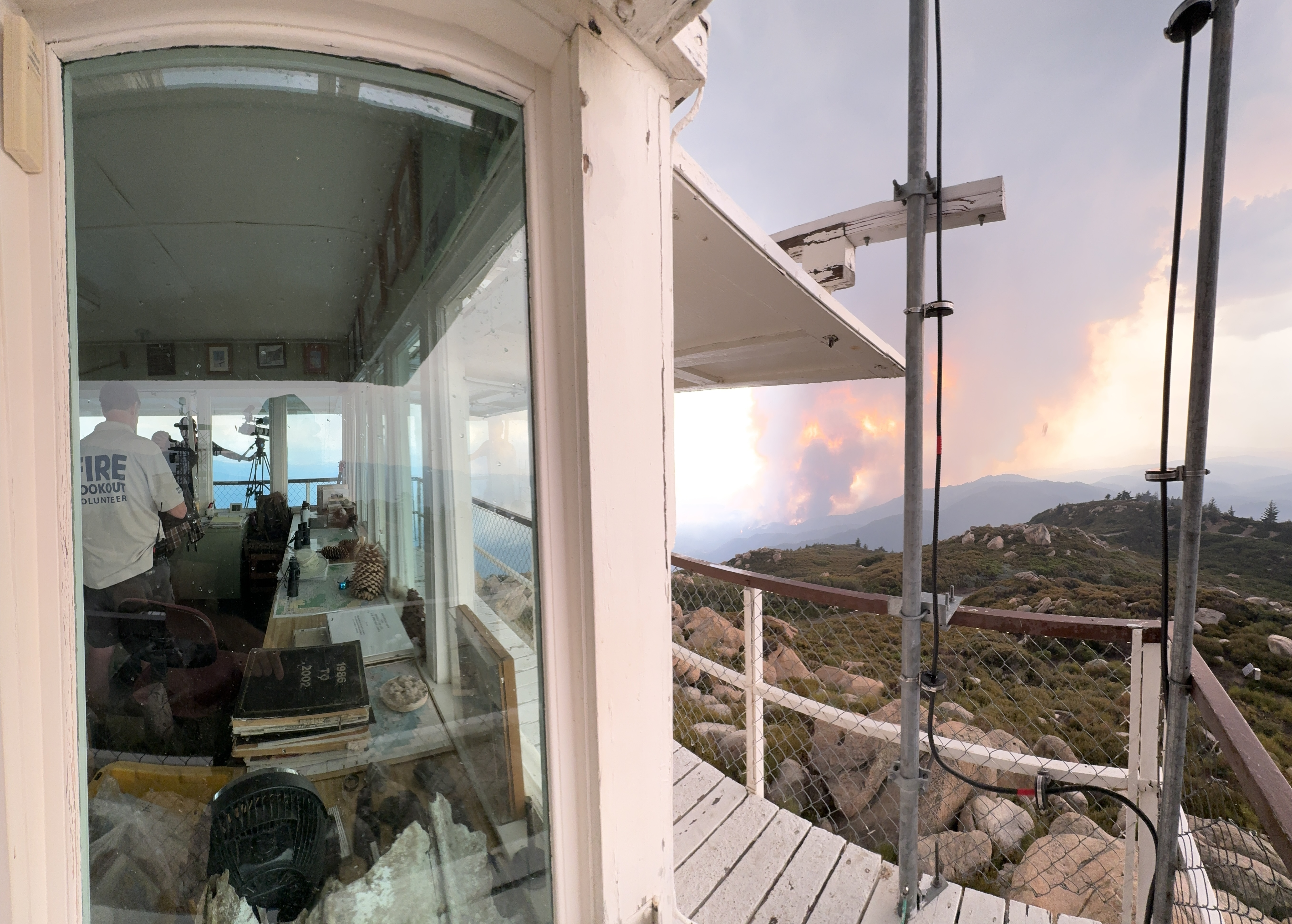
Went to Keller Peak lookout Sat. Sept 7 to view the fire, was in the tower talking with the volunteer lookouts when the mandatory evacuation order came in and tower was closed. I believe these are some of the last images taken of the tower prior to it’s loss on the 10th. Had a weird feeling and decided to take some photos of the tower just in case… well the just in case happened. Bummed that the vintage Osborne Fire finder, in addition to the 98-year old structure and historic artifacts in it were lost.
And yes, that’s rain on the tower windows. Was hailing and 60 degrees when the tower was closed.
41 Likes
Any updated intel on what the fire is doing in bear creek?
2 Likes
Such a bummer , lots of towers lost in last few years
Hopefully the Osborne is found and maybe salvageable
9 Likes
Thanks for the photos, it is sad, grew up on the mtn. Been there many times, I worked out of the Deerlick station at the bottom of the road up to the lookout on Hwy. 18 in the 70s’. Ray Redding was the lookout then, been there for years. When the Bear fire in 70 went over the top of Keller Peak he rode it out in his pickup parking inside the microwave compound below the tower. In the middle of the first night he lost his animometer at a gust of 105 he told us.
12 Likes