Regional USAR Task Forces being mobilized
4 Likes
2100: summary of the day - have been busy away from intel. Notes where I can but couldn’t keep the big picture painted in my head.
Map Data: Friday Ops Map with IR data from 543pm Thursday. MODIS/VIIRS data of last 24hrs, with recent VIIRS pass about 1230pm Friday. Green highlights are primary lines, yellow alternate, purple contingency.
Overview of Ops, black line, plus what still has some heat.

Branch 11 in the Bloomer and Berry Creek area. A lot of fire right up to completed dozer line which is good and will hopefully be black line in the next 24. Div MM fire behavior this morning was backing fire with no significant threats.
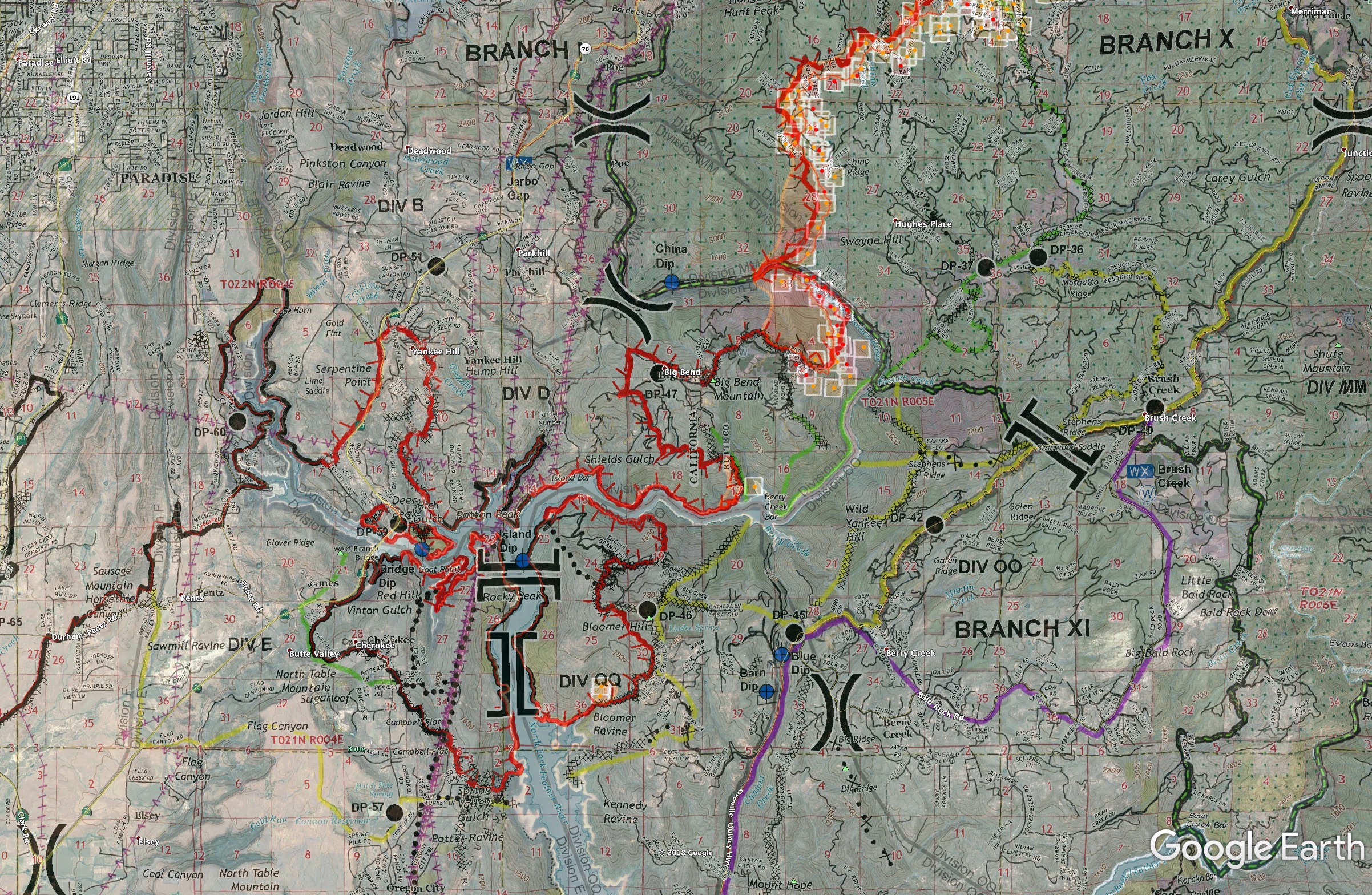
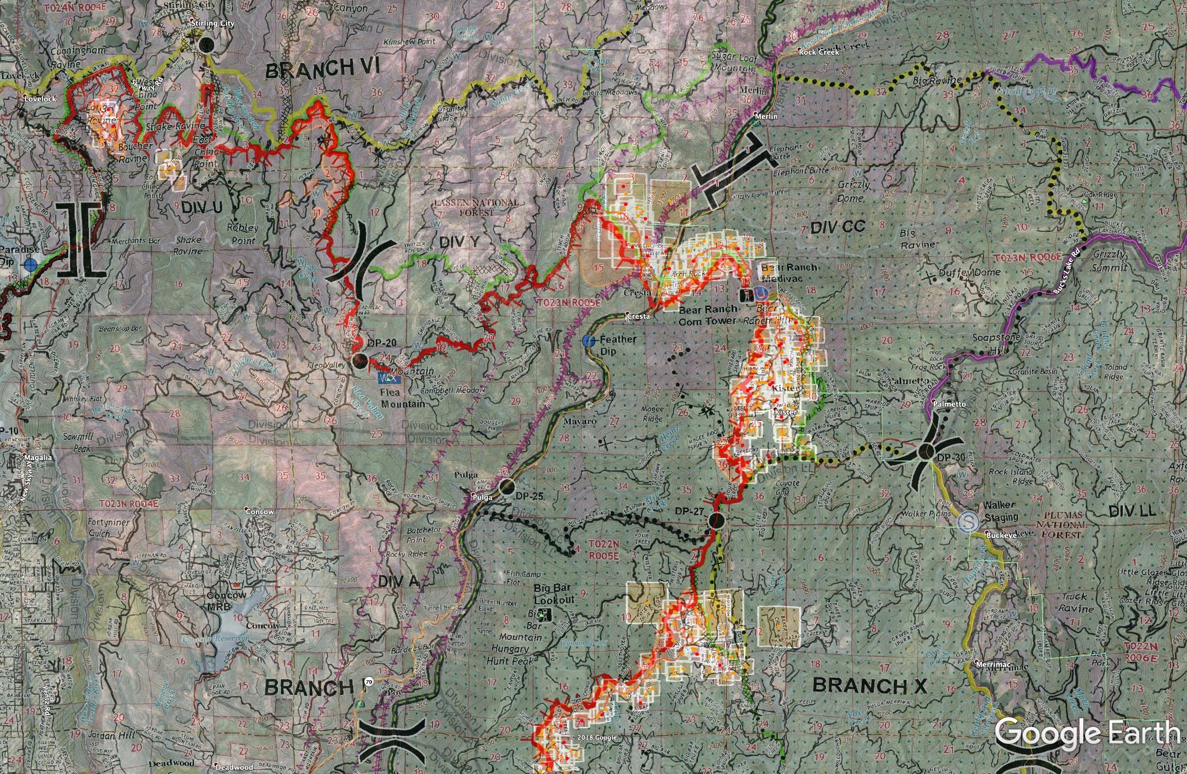
Branches 6 and 10. Successful firing ops holding around Stirling City. Lots of heat right up to the primary line on Div U, not sure if firing or wild, but no MODIS/VIIRS hits on that spot 14 hours after IR data. A lot of firing ops in Branch 10. Div CC burn last night was holding but it was pretty dirty, mosaic though the burn. They created a Div DD in the Grizzly Creek area. Div LL firing ops the fire got hung up at Priscilla Spur (mess of heat near green line bottom of map). They wanted to get a good hook along that line to the south. They’ll try again tonight. Up in CC/DD they are building some check lines way out on the ridges around Grizzly Dome into the creek and Duffy Dome incase they want to fire off the bowl there and tuck in the box a bit from the current proposed alternate line.
President visits the area Saturday, landing at Beale AFB. Unknown time at the moment. 30mi TFR radius around Beale and Chico. All firefighting aircraft are exempt in the TFR as long as they are within the confines of the actual fire TFR. Expect some interesting radio traffic, maybe even coordination between Air Attack and the combat air patrol. When President Bush visited Redding during the 2008 fire siege, he did a fire tour west of Redding. Air Attack was in contact at the time with updated locations etc. of Marine One.
5 Likes
Any more info on the USAR FEMA Task forces?
They will not be FEMA USAR TFs. These are in state Rescue Task Forces. Same ones used during the mud slides in Santa Barbara. So far the Fresno TF is the only one confirmed.
2 Likes
Some FEMA USAR members have been activated.
1 Like
RTF 12 from Santa Barbara County is en-route.
3 Likes
LAFD and RTF 4 from So Cal en route
1 Like
Been working in Div A/B & D last three shifts. Looking real good in there. Big wind event coming today, all waiting to see how the line holds.
2 Likes
4 Type-1 rotor on order to pick up ~1ac slop over the line on Camp Creek Rd. in Div U.
Edit: Sounds like it’s actually on Div Y.
Saturday 11/17 0600hrs 209 highlights:
148,000 Acres @ 55% containment
9,700 single residences destroyed
Evacuation Orders: The communities and areas surrounding Concow, Magalia, Paradise, Pulga, Big Bend, Berry Creek, Bloomer Hill and Stirling City. Evacuation Warnings: -Little Chico Creek Area (north)- -HWY 70 from HWY 149 north to Pentz Road -The area of Cherokee Road north from Table Mountain Blvd. to Red Tape Road Total persons under Evacuation Order: 47200 Major Road Closures: Portions of SR-70, SR-191, SR-162, Durham-Pentz Rd., Skyway Rd.
Weather Concerns:
Steady northeast winds occurred across the ridges and along the Feather River canyon last night, with lighter winds and dry conditions in the thermal belts. Light winds and dry conditions are expected today during the daytime. A Red Flag Warning has been issued for tonight evening through tomorrow afternoon for gusty winds and low humidity, as we expect to see stronger Northeast Winds. Rain is likely over the fire area late next week starting Wednesday. Red Flag Warning has been issued for tonight evening through tomorrow afternoon. Observed Weather Conditions: Winds: NE winds 5-10 mph Temp: 50 RH: 20% Forecasted Weather for Next Operational Period: Winds: Upslope winds 3-6 mph Temp: 65 RH: 15%
Projected Incident Activity/Movement:
The fire area is still under the influence of low relative humidities and fuel moistures. Moderate to active fire behavior is expected including the potential for spotting and torching with slope driven runs and wind driven runs in the Feather River canyon area. The fire will continue to burn to the NE impacting the communities of Magalia and Paradise Pines. Crews will continue to conduct structure defense and perimeter control. The communities of Stirling City and Paradise Pines are still threatened. The fire is currently in the footprint of the Poe Fire on Federal DPA. The fire will continue to burn to the SE toward Big Bend where structure defense will continue and threatens Berry Creek, Cherokee and Brush Creek. The fire is currently holding to the east of the Chico city limits at Hwy 32. The fire is holding to the south at Hwy 99 and Hwy 149. Resources will be prepositioned in preidentified locations for the forecasted wind event tonight through tomorrow afternoon. Crews continued tactical patrols in the communities of Paradise, Concow, and Magalia.
Critical Resource Needs:
6 HEQB’s
Total Personnel Assigned: 5,632
2 Likes
AA ordering up 2 VLATs to put some retardant down in the Grizzly Creek area north of the Bear Ranch towers.
1 Like
T944 is inbound with T912 in behind it.
5 Likes
Airshow laying down heavy paint in Charlie-Charlie, connecting the dots from Elephant Butte in Sec. 6, to Grizzly Dome (Sec.5) and across the drainage to Duffey Dome (Sec. 16) to the south, and tie into Bucks Lake Rd.
2 Likes
FEMA Task Force 3 out of Menlo Park Mobilized
4 Likes
Evening Media Brief, 1800
149,000 acres, 55% contained
- red flag continues tonight until tomorrow afternoon
- 5624 personnel assigned, 46,031 people evacuated.
- Structures destroyed 9700 SFR, 191 multi-fam residence, 8 mixed res/comm, 367 commercial, 2528 other = 12,794 structures destroyed. additional 470 damaged.
- 5 additional casualties discovered today. 76 total confirmed deaths.
3 Likes
Task force 6 from Riverside enroute.
2 Likes
Busy day in the air, AA says they have 12 rotors working the east side, CAP wants 2 photo flights over the Paradise area, there are up to 40 drones working in the city of Paradise, and PG&E wants a drone flight over the origin.
4 Likes
153,336 acres and 95% contained.
3 Likes
The Camp Fire is 100% contained. 153,336 acres, 14,500 structures destroyed, 85 confirmed fatalities, 271 still on the unaccounted for list. By far the worst incident I have ever been on in over 44 years on the job. Outstanding work by all emergency responders involved from IA, major incident response, the US&R Task Forces, volunteer SAR organizations, Law Enforcement, EMS, and many, many more.
27 Likes
2 posts were merged into an existing topic: CA-BTU-Camp??