Ty ash….yep…been doing this a while….map?
More likely planned need.
LNU just punched out a ST/E for Chico Fairgrounds, so some of that 40 is going to be Planned Need.
Also, the real value is going to be that 40 Request vs. the UTF quantity, especially considering that the Tamarack is not done yet
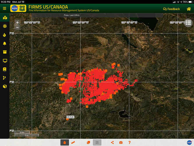
You should be able to get whatever maps you need when you get there…but here is the link to today’s ops map
Can you clarify, was this for 40 engines, or 40 strike teams? 40 Strike teams would be an awful lot of engines and would almost have to be by definition “any type”.
40 Any Type Strike Teams
40 S/T Anytype all ordered CFAA mission on 3 digit request numbers(Not Fed Mission)
The notes say "prefer type 2,3,4,5,6.
The orders are being placed throughout the state
Oh yeah
3 more Limas on state mission
28 Doz type 2 on fed mission
Marathon time. Another historic fire. Work together, watchout for yourself and everyone around you.
Of course….TY for posting.
Looking like it is planned need. I am thinking of what Operations said at last night’s press briefing, about the terrain not being good dozer country. He said it would be hand crews and engines.
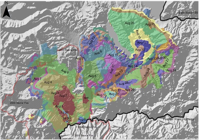
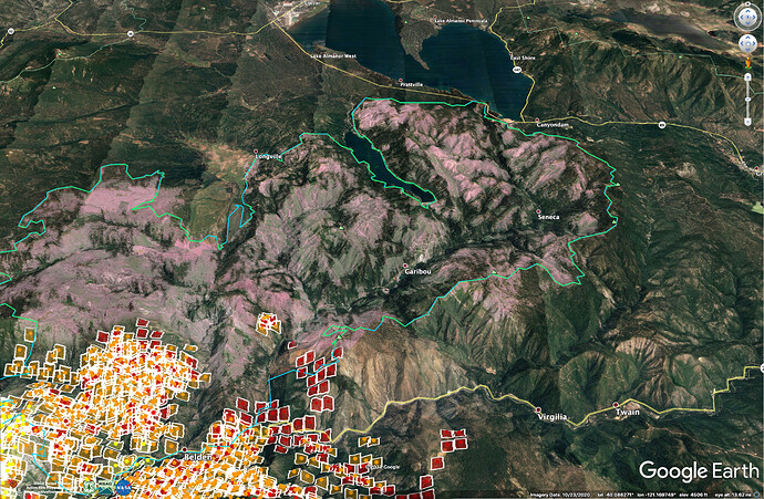
There is not a lot of work for 40 strike teams of engines anywhere between Lake Almanor and Belden, but plenty of work when the fire gets there, or gets to Greenville or Meadow Valley. It could be a while, though. The Chips Fire, shown in blue and green in the Google Earth image below, got large because of lack of places to tie in fireline in the gnarliness of the North Fork Feather, coupled with spotting and a generally high resistance to control in the heavy fuel loads of the twelve year old Storrie Fire. I wouldn’t expect we are going to pick up this fire within a much smaller box than the Chips Fire on the north end.
It took almost 3 weeks for the Chips fire to get from Belden to the West Shore of Lake Almanor. 2012 was also a critically dry year, and the ERCs were in the 97th percentile. Read about Chips Fire behavior here:
Here is the 2pm VIIRS looking up the North Fork Feather. The base image is manipulated to show areas that burned hot in during the 2012 Chips Fire (blue/green outline) in pink.
Red Hill, from Kurt’s post, is in the center of this image. It is called that because of the weathered, rusty serpentine soils and rock. Not much grows there.
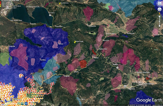
Notwithstanding the discussion below, Rush Creek (next canyon to east of Chips Fire footprint) stands out as a place the fire could continue its big push. It is aligned with the main Canyon of the Feather, and unlike the ground burned by the Chips Fire, it has no large fire history for the last 60 years. The Dixie Fire ran about 10 miles in 24 hrs on 7/18 and 7/19 with extreme instability in the atmosphere. Weather is forecast to gradually get drier and more stable, but tomorrow and Wednesday will still be unstable, though not as severe as last 2 days (thanks Julia Ruthford for excellent briefing tonight).
100 years of fire history (or lack thereof) with 7/19/21 1400 VIIRs data. All of the historic fires in this area have run toward the NE.
Regarding the spread of the fire toward Lake Almanor: Many of us were worried the 2012 Chips Fire was going to blow straight up the North Fork Feather (Caribou, Seneca, Canyon Dam), and up Keddie Ridge/Dyer Mountain (right of East Shore label), but fires in the past here haven’t often run straight up the main canyons of the North Fork Feather River or East Branch (Feather River Canyon above Caribou Road). This year may be different, but in the past, fires in the deep canyons get some alignment in the afternoon and take out a side drainage where the upcanyon is blowing directly onto a solar slope. During Chips, we got a lot of backing and flanking fire in the time periods outside of the major runs, and that’s a big reason there are still a lot of trees on the slopes that are sheltered from this alignment. Areas that got these sort of aligned runs in 2012 are highlighted in pink on the second map, above. Haines index of 5 or 6 was a good predictor of major fire runs in the Chips Fire.
Obviously this is a long-haul fire, and how similar it behaves to Chips is an open question. It’s hard to tell how having all of the completely-exposed 9 year old brush and slash from dead trees in the Chips burn will affect rates of spread. But the portions of Chips that burned in the 12 year old Storrie Fire had similar fuels to what we’ll see in the Chips Burn, and topography and winds haven’t changed, so I expect we’ll see very similar localized runs based on daily weather patterns and periods of instability.
The flats south of Almanor have a lot of roads and large areas which were salvage logged and are very [open and cleaned up] (ALERTWildfire | Shasta Modoc). These things will keep the fire from running hard right at the Lake when it gets there.
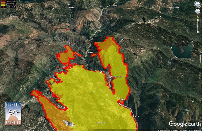
The fire on the east side of Highway 70 is going to have some of the same factors at play. An important thing to consider on fires in these broken canyons (or in most canyons) is that at any given time, half of the landscape is out of alignment with the wind and sun. That’s why we often see only 50% of the landscape burning with high severity. The Bucks Fire was another long-hauler. On past large fires like the Bucks, Camp, or Bear, unless you have a long stretch of canyon exposed to the upcanyon wind (for example where the fire ripped above Rodgers Flat yesterday or toward Virgilia today) you just haven’t seen huge upcanyon runs, and things are driven more by rollout and slow flanking, with the occasional larger run up an aligned slope.
IR Map of fire spread above Tobin, 7/18/21, 23:45 hrs.
Very well written, good information / history.
Thanks. I just came across the Chips Fire Behavior Report - hadn’t seen it before. Good reading for anyone headed to this fire. https://www.fs.fed.us/adaptivemanagement/reports/ChipsFireBehavior_Fullreport_16Jan13FINAL.pdf
It’s a long ways across Lake Almanor, but what’s the threat of spotting across since its heading that direction?
I know there is a lot of opinions/discussions in this forum about history and fire behavior. I think it is very valuable to pay attention to the past.
40 S/T is only 20 S/T a day working 24/24 On/Off.
Watching the evening PIO report the Plumas County Sheriff expanded the Mandatory evaluation zone. With the long turn around times, the fire getting zoned out and the requested "Prefer Type 2,3,4,5,6 " It would appear to have both structure defense and hose lay resources were the thinking.
Spotting across Lake Almanor is not going to happen.
Doubtful that it would spot across the lake, it is more likely that the fire will flank around the lake.
What I was thinking but this is some crazy fire behavior. I appretiate your experience in this area and your expertise! Thank you…
