I saw it… and great answer. One that should be bookmarked for future reference.
Pretty intense thunderstorm SW of Portola. Not here yet but I can hear it. Definitely getting some of the outflow winds.
Well the lightning has arrived but no rain yet.
So far I’ve only seen cc but visibility is pretty bad.
And some rain finally arrived. Lot of lightning about .5 mile straight up.
Some cg over by smith peak. A lot of storm seems headed wnw. Though still rain and lightning here.
Looks like some crazy stuff in the area
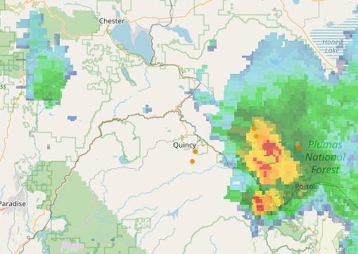
I’m on the outskirts of that got about .1" of rain. Thunder is pretty neat continuous and some pretty intense cg. A lot of eyes are probably going to be watching around Smith Peak for awhile.
The fire in Rush creek blew out and got a little dicey topping out 40-45,000 ft for a short bit in the last 3 hours. Location given during the evening update.
Evac order just came across the TV for Genesee Valley and the remainder of Indian valley. Is this due to the lightning fire mentioned in the main Dixie thread?
Really?got nothing by phone or radio. Nothing showing on evac map
https://buttecountygis.maps.arcgis.com/apps/webappviewer/index.html?id=9c92e0a2d2e0415fa5248d70cd644a82
The most intense lightning strike I saw did start a fire on smith Peak only thing I’ve heard is crew are at it and it’s 40x40’. Hopefully get out fast. Another one about 9 miles SW of me I can see lights of responding units. Busy night.
I know. I can’t find anything online either. It definitely came across the TV though.
Evans fire to the north is 10 acres and the Kessler is closer to genesee at 5 miles. If these fires do something it’s better for them to issue evacuation orders now.
The map says Taylorsville and Genesee are under an evacuation order.
Gotcha, thanks.
Yeah the genesis section has gone orange now…the Taylorsville section already was. Nice to know they didn’t get the alert out on radio or phone…some of us don’t have tv.
I can’t believe it’s so hard to find online just looking for it.
I found that from someone here. Though it is also listed on inciweb under the Dixie. But yeah just looking for it with duckduckgo and nothing shows at least on the first page 
I guess the area was already under an evac order but people had stayed behind. I wonder if the lightning fires prompted them to send out the message again?
Well they are being extra cautious but the biggest one is 10 acres I believe seems a bit early…but anymore things move so fast. But I wouldn’t be surprised if the thunderstorm winds spread the Dixie out there. I got some 40mph gusts.
I know they changed the map earlier removing some warning zones and in my memory Genesse was in yellow but then the memory isn’t what it used to be. It’s an odd shape the section zone of the map that includes Genesse so unless you zoom it it’s easy to not notice.
Copy that. Hopefully they get the lightning starts.
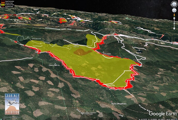
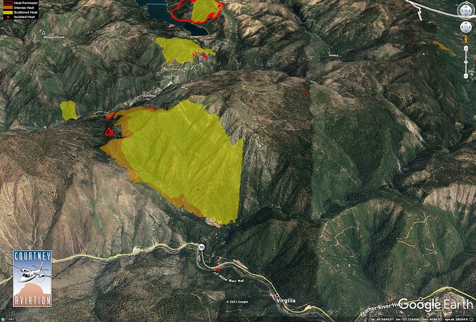
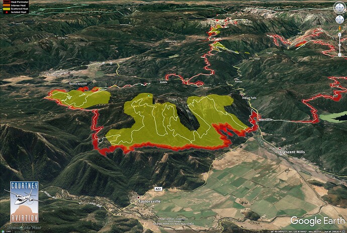
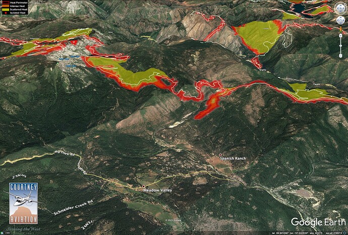
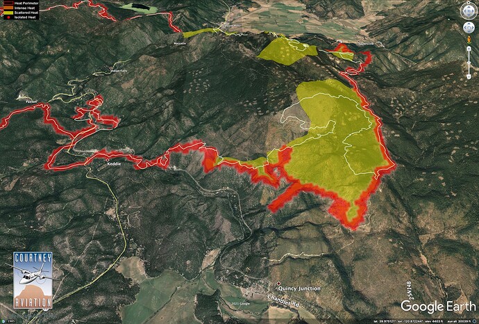
7/30?21 IR @ 0100 hrs.
Got to make a lap around the fire yesterday, up Hwy 70, over Mt. Hough, and back on Hwy 89 to Humboldt Road and out to Butte Meadows. There was heavy smoke in the Canyon and in Indian Valley in the morning and early afternoon. In general, things look great. We saw very little active fire on Mt. Hough or Humboldt Road.
Big firing op around Butte Meadows wrapped up yesterday. This made the huge column visible from Valley. White lines are Dozer lines. Firing is tied in all the way around the NW side of fire, now, from Butte Meadows to Canyon Dam. A lot of Humboldt Road was fired at night with drones, and right by the road looks great! Further interior there is some high-severity burn where firing ran up slopes.
There was a good-sized run up and out of Rush Creek yesterday afternoon.
The fire is tied in to the Emigrant Road, above Taylorsville. Spanish Ranch area. Firing on finger is dozer line.
Firing on South side of Hough was just kind of skunking around. A lot of the burn right along Mt. Hough road underburned in thinned plantations. There was some high-severity fire on China Grade road, where fire spotted into the lower slopes and boiled back out running toward south.
Hello… I am from Indian Valley. I just wanted to say since being evacuated it hasn’t always been easy finding out info on what’s going on, the main fire briefings are helpful sometimes, sometimes they wouldn’t even mention Indian Valley even though the fire was going straight for it. News articles are usually giving info that’s a day or two old, so most of the community looks to forums like this one for updates about their area. For one I really want to thank the people that are giving us good updates and info… pyrogeo guy and some others, thank you!!! Unfortunately I’m here to ask some of you other guys that seem to be here as a hobby and not actually are effected by the fire to PLEASE STOP. Gooddog… we don’t care about what the weather is like everyday at lake Davis!!! 720 post in this forum so far and half of them are about what app works best for looking at airplanes and what the weather is like at lake Davis. Although that info might be relatable to our fire it’s actually not very helpful and very frustrating scrolling through trying to find info that matters to the people who’s communities are burning down. Thanks, from all of us.
God bless you all and let’s keep praying for rain and everyone’s safety.

