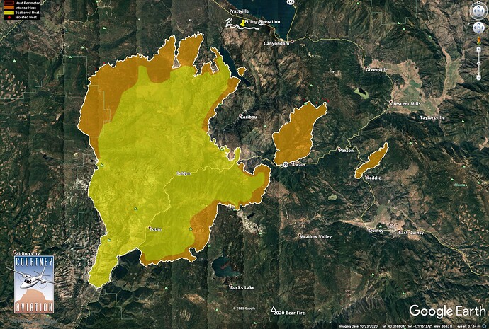
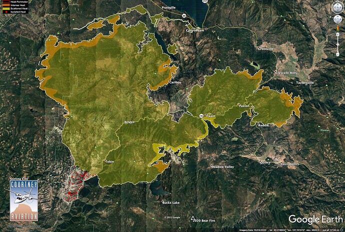
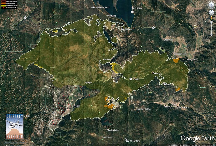
The west zone had more favorable conditions with their firing ops and could burn during the day and on the flip side that makes it harder on the east because they have to wait for night time.
Its the same age old debate. Maps are linear, work is not. If a fire is 30% contained that means that 70%, scattered around, still need work, which doesn’t translate well to a black line on paper. A better way would be to have 50 shades of gray lines all around the map, which wouldn’t work well either.
Percentage of containment is a political number having nothing to do with remainder of open flank. 100% contained means all suppression repair is done and base camp is cleaned up. When an incident is declared 100%, emergency funding is cut off to that incident.
Exactly. When there the fire is out, and dzr line is being repaired and there is say 8% of the overall work left, you have to draw 92% of the perimeter as black. Where that 92% is…completely irrelevant. The time it takes to work doesn’t translate to a 2D linear map.
I think you’re confusing contained with controlled. Two separate definitions.
Well, back to the fire.
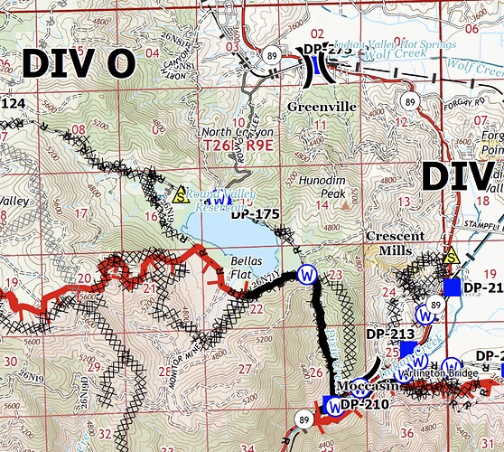
Indian Ridge cam shows the fire is cooking up a little just south of Round Valley Reservoir. Air has just cleared in past few minutes and column went from white to brown. Looks from today’s Ops map plus yesterday’s IR like they fired this area (Bellas Flat) last night and it is still burning out?
http://www.alertwildfire.org/shastamodoc/index.html?camera=Axis-IndianRidge&v=fd40730
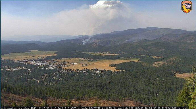
Some buildup over that part of the fire, and a little (interior) run starting on Fly side of fire, too.
http://www.alertwildfire.org/shastamodoc/index.html?camera=Axis-EastQuincy&v=fd40730
http://www.alertwildfire.org/shastamodoc/index.html?camera=Axis-SloatMtn&v=fd40730
As I have said in a different thread, comparing incident management teams from different agencies or sponsorship is apples to oranges. They operate under vastly different operational environments. The NWCG sponsored “Federal” teams were originally designed to manage fires on federal land (now defined as "The NWCG sponsors wildland-fire-focused multi-agency teams that are designed to manage wildland fires on Federal lands, as well as state and local lands, per agreement and request.) Managing a fire on land you own is far different from what CalFire does. The vast majority of land the CalFire IMTs manage fires on is private land – not state owned land. That is a huge difference since you can’t let someone else’s land burn “for the good of the resource” unless you want to have your name on the lawsuit. So CalFire teams do not have “resource benefit” as an alternative, they must put them out. The size of the boxes are the only alternatives. That being said, by the time the incident got to Type 1 complexity we (I was an LG person on a Fed sponsored team) were not really there for resource benefit. The WFDSS and all it’s predecessors did permit more options. But don’t confuse capability and professionalism with operational environment and constraints. Apples to oranges.
Key point in California, however, is that there is significant amounts of private land in federal DPA. Meaning most large fires with federal teams usually aren’t just on their land.
Ok Ladies and Gentlemen, back to questions pertaining to the fire itself.
Sloat Mtn cam has a good big-picture view of the NE portion of the fire.
Looks like it really wants to pop the cap up higher, but doesn’t quite have the heat.
http://www.alertwildfire.org/shastamodoc/index.html?camera=Axis-SloatMtn&v=fd40730
Completely agree. As the Dixie got larger the land ownership became more complex and added to the incident complexity and operational/strategic limitations and constraints a team must operate under. I do remember times when portions of a fire breached the wilderness that those parts could and sometimes were managed differently. My point to the OP was that making assumptions, even implicitly, about capability and professionalism based on who puts fire out versus who manages fires is irrelevant. Tools in the tool bag are just that. The Dixie, being managed by two different teams, will also be operating under a range of conditions. What one team does on their zone may or may not be available as an option to the other team. Land ownership and the Agency Administrator(s) determine that. People need to keep that in mind when comparing zones and teams. When I was on a team on home turf (a contract county) we had to operate under policies and procedures quite different than my Federal friends on their lands just a little ways away.
Not accurate.
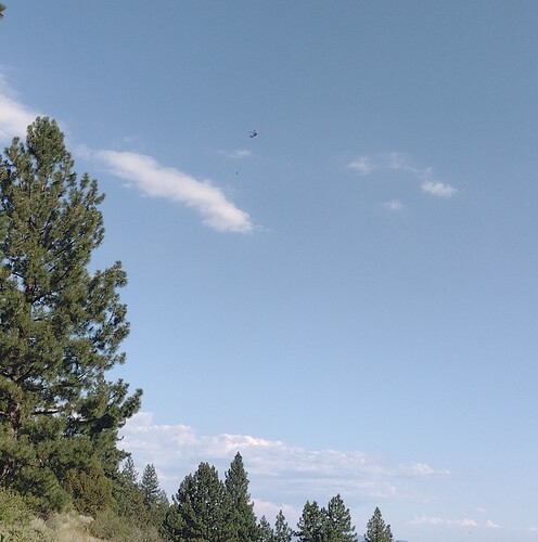
Just spotted this chopper heading back to the fight after a pit stop at Nervino. I feel like saying something out of a WWII news reel like: go get 'em.
Looks like the forecasted return to winds is happening. Winds are picking up. About 15mph now.
Zaca, Station, Day fires seemed to be exactly like your description. Thanks for the insight.
Butte County Federal/State Land Use Coordinating Committee-
West Shore Community Wildfire Protection ProjectAlmanor Ranger District, Lassen National ForestPlumas County, CaliforniaAugust 2019
Interesting read, with maps…
Before we make this too complicated, a big part of the explanation is timing.
7/22/21 IR Map.
On 7/21, the big new run in Rush Creek and the Fly Fire hadn’t even started, but we were already firing along Highway 89 and building the contingency lines that ended up being the controlled edge of the main (western) part of the fire.
7/23/21 IR Map
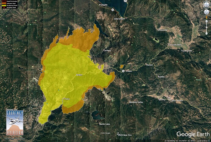
The Fly Fire and Rush Creek Fire took off on 7/22. We didn’t start to go direct on these fires until conditions moderated early last week. So a big part of the east zone really could be considered their own new fires which started days after the west zone was already going.
7/27/21 IR Map
We went indirect on Mt. Hough Road and at the base of Mt. Hough on Arlington Road. The fire took some time to get there, which helps explain these lines not turning black sooner.
7/31/21 IR Map
Not me but this may help.
https://m.box.com/shared_item/https%3A%2F%2Fcalfire.box.com%2Fv%2FCALFIREIMT1/browse/141385851968

