Seems wrong to ‘like’ this post…
11 Likes
10 posts were merged into an existing topic: Airbase Capabilities Fuel & Retardant
Indian Ridge cam continues to show activity
1 Like
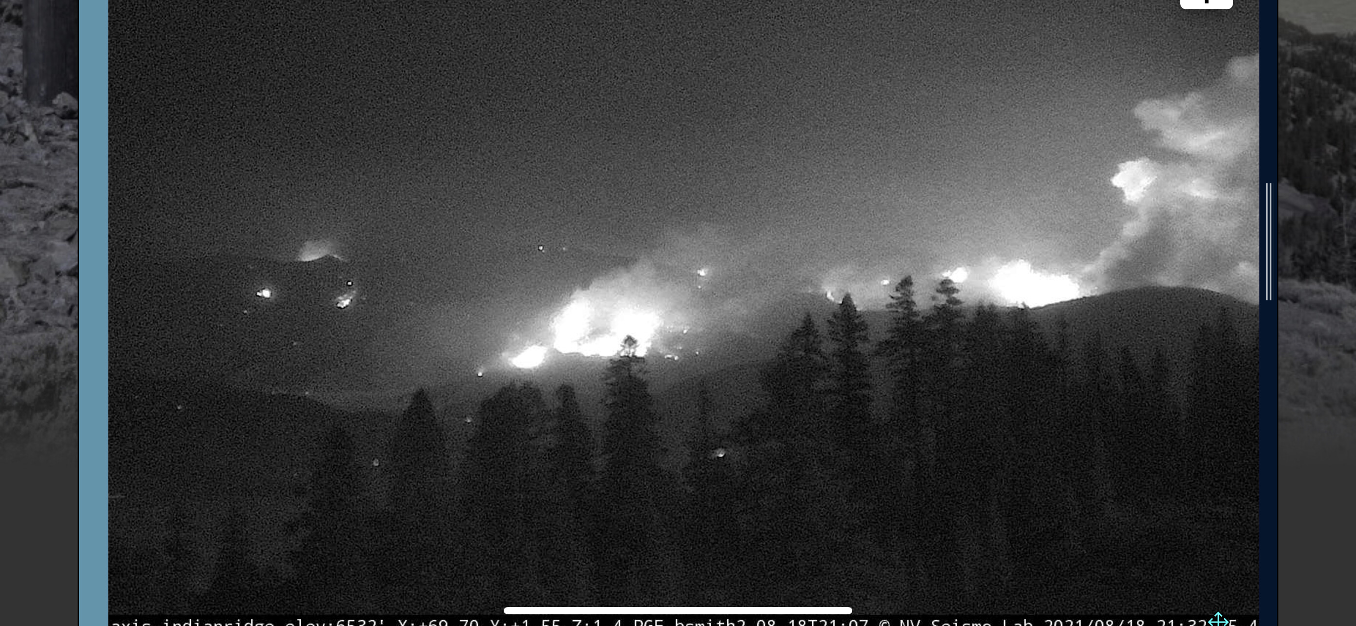
Beardsley grade to the middle left. Mt Jura is the foreground on the right side, with the fire that jumped Beardsley yesterday burning behind it.
2 Likes
Just drove back from Standish to Chester by way of Portola, which basically took me around the entire southern perimeter, if this fire could be said to have one. That took me down 395 past the still-burning Janesville arm, while tankers were dropping on it (mostly just the Bae-146s out of Reno); then up through Portola past the Beckwourth Complex, then through a very smoky Quincy, then up 89/70. Which is just completely gone. It was dark by the time I got there, but 50 miles of one of the most scenic drives in the country is now gone - there were barely a handful of green trees left. Greenville and Canyon Dam were wiped out.
I’m glad it was getting dark (partly because of the smoke) by the time I made it past Quincy. Saw plenty of flame even right alongside the road, and up in the North Arm passing through Indian Valley. Bunches of burnt-out vehicles.
It was really, really disorienting driving up from Greenville on in the almost dark, because none of the skylines/features that were normally landmarks in the dark made sense anymore. I don’t look forward to seeing what daylight brings.
16 Likes
Relatively clear air in eastern Quincy this AM. 49 at my place off Chandler. Calm. No ash falling. Most of the smoke to the west at the moment…
3 Likes
After reading the comments regarding holding 395 I feel the need to clarify. I too was on the Eagle Fire and was assigned on the north side of where the fire whirl occured that resulted in the burnover. An important detail that is often overlooked is that the strike team of engines involved was just arriving to the fire. They were not at the morning briefing, had not been assigned, were not familiar with the ground and proximity to Honey Lake which held water in 1989. They saw spot fires and reacted as aggressive firefighters would. They were not familiar with local weather factors specific to the escarpment.
Fast forward to the Dixie spot fire that eventually crossed 395 a few times over 2 days. It was much less dramatic this time. Not only was I there again but, I directed resources to take action on the fire east of 395. There are homes, ranches, infrastructure, outbuildings, summer graze, and is all private property. Every effort has to be made to protect it. And it was protected without injury in an aggressive manner with a priority on safety.
It’s easy to second guess actions that occured 32 years ago and assume the same results will occur as if there were no lessons learned.
44 Likes
The new 25-50 acre spot and the wind direction today is worrisome to me for Quincy folks. Aug. 19: Dixie Fire still threatens multiple communities - Plumas News
1 Like
Yeah. Saw that. Rotor wing from Quincy appear to be working that now. Hopefully the contingency line keeps moving along…
2 Likes
@High-Lonesome thanks for the context. Sorry to have second guessed the situation without good background. I guess it’s never a good idea to judge a situation based on a reporter’s edits of the 30 seconds of gnarliest footage he shot, so sorry I went there. Thanks for everything you’ve been doing to save so many people’s bacon.
It was spooky to see the footage, though. One of the guys critically burned on Eagle had family in my hometown, so the incident has always been kind of seared into my memory.
6 Likes
Looks like T911 is on it’s way, along with various other fixed wing. The whole air show is active today, mainly working the escarpment areas.
1 Like
T93 and T94 working out of Chester, MAFFs and others also in the air (just saw a C-130 go over here on its way back to Redding).
On another note, my ADS-B receiver came in and I got it hooked up just before I evacuated, and is reporting traffic around Chester a lot better on FR24.
12 Likes
A friend just sent me this link:
[Zoom Earth | LIVE weather, storm tracker, wildfire maps]
Had not come across this one before. Cool to be able to overlay the wind on a rough overlay of the fire.
7 Likes
That would be seriously screwed up if this monster burned right back along a cold edge and threatened Quincy again.
Yes it would. That has been the worst case scenario for about 3 weeks now…
4 Likes
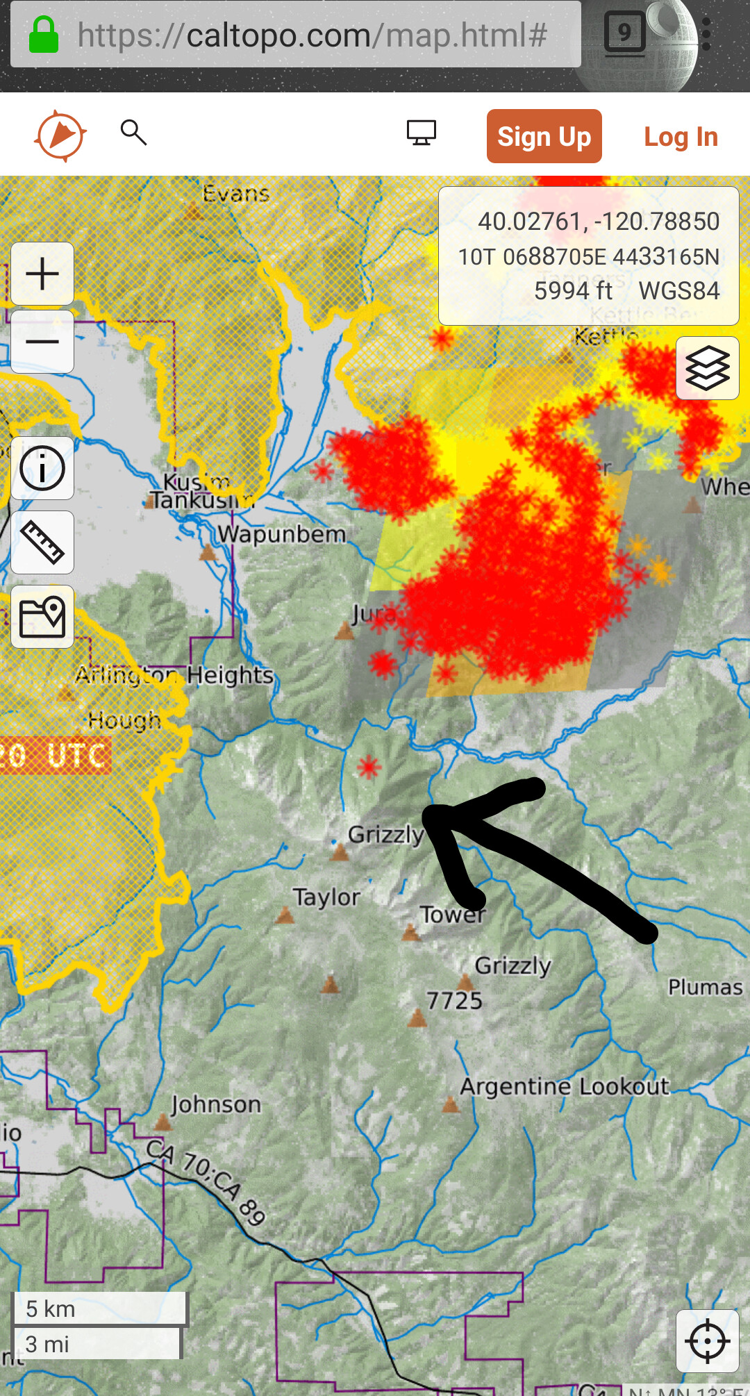
I can’t believe it apparently there is a spot up on grizzly in the devil’s punchbowl area I hope they catch it. I feel it should be an extremely high priority
3 Likes
I completely agree. If that spot gets established and comes over the ridge, Quincy to Cromberg area become threatened.
1 Like
Not to mention grizzly ridge is one the last areas on the Forest left, this is horrifying from the nature perspective.
Greenhorn ranch cromberg massack east Chandler road area are not good places to defend homes if we get another north wind event
2 Likes
Courtney Intel just added updated IR. Showing a spot fire on the eastern aspect of Mt. Jura and another mid-slope on the northern aspect of Grizzly Peak. Fire continues to back down Forman Ravine on the Taylorsville side and Hosselkuss Creek towards Genesee.
On the Coyote side, pretty aggressive firing op along the 36.
In the north, the big thing is Mill Creek still. Seems inevitable it is going to establish in the drainage and work it’s way west.
1 Like
Even portola area could come into play if it gets on grizzly ridge and starts moving west
2 Likes