CA-BTU-Dixie(contained)

Caltopo current heat spots (still 3 hours old) power lines seen if you zoom in:
https://caltopo.com/map.html#ll=39.99465,-121.28168&z=13&b=t&o=f16a%2Cr&n=1,0.25&a=fire%2Cmodis_mp%2Cfeatures

Seems that it might be into Belden by now.

Quincy (East of Incident)
https://wrcc.dri.edu/cgi-bin/rawMAIN.pl?caCQUI
Click on daily summary and submit info for current day.

Jarbo gap RAWS: (way west of incident)
https://raws.dri.edu/cgi-bin/rawMAIN.pl?caCJAR
Winds gusts @ 1400 was 19mph
1800 now @ 10mph

5 Likes

Data Package is up. maps.takserver.us

4 Likes

15,000 acres, 15% contained this AM

6 Likes

AA-210 reporting the spots across Hwy 70 are well established & moving in all directions. This was reported in the Feather River Canyon. Tankers are working the spots but they are not going to catch them at this time.

Plumas County Sheriff has issued a Mandatory Evacuation Alert for the communities of Bucks Lake, Meadow Valley and Hwy 70 corridor from Rich Bar to Twain

8 Likes

A post was merged into an existing topic: NV-HTF-Tamarack???

From a CF Team 1 member supposedly 1300 acres across the river and 70, sounds like a whole new ball game

6 Likes

BCSO sending multiple deputies up to Bucks Lake mutual aid for Plumas SO/SAR for evacs. BCSAR is primary on the High Lakes side, Philbrook, Jonesville etc. Sounds like Cherry Hill campground is the line between Evac Order and Warning, with the Butte Meadows and Inskip communities falling into the Warning category now. LNF resources also doing notifications in the high Lakes area, Snag Lake etc.

8 Likes

Starting to cap out. Taken from I 5 at Jellys Ferry rd

5 Likes

Three views of Dixie. IR from 23:45, 7/18.21.
Blue is 2012 Chips Fire. Data source: NIROPS (Courtney Aviation is Contractor).

6 Likes

Ops map

Sorry your map was unable to be displayed, please try again

DATA PACKAGE IS UP AT MAPS.TAKSERVER.US

1 Like

Not again

3 Likes

Summary from the incident report sent to the PUC from PG&E:

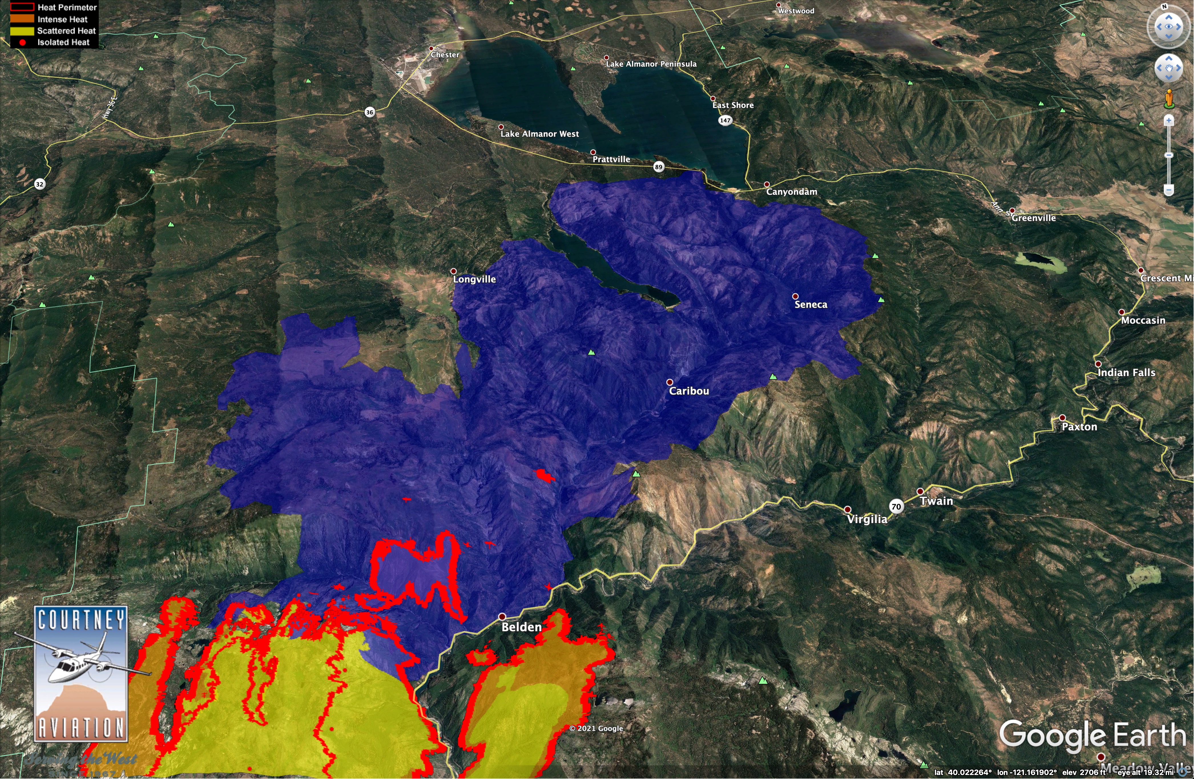
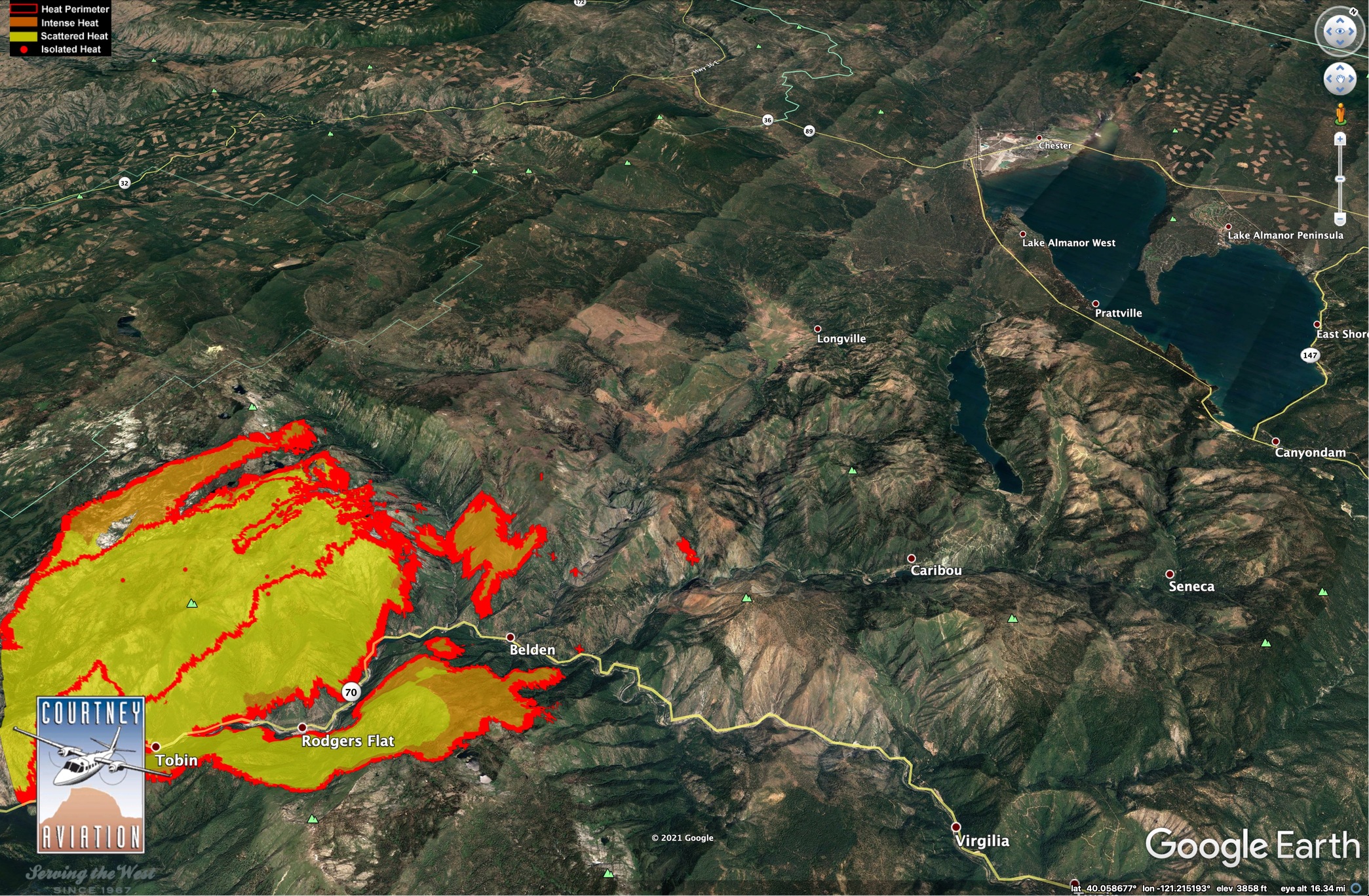
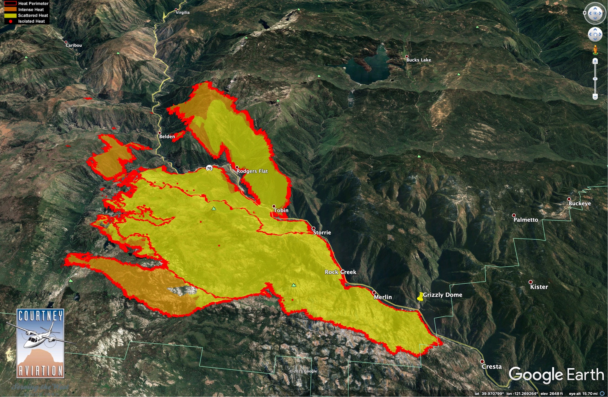
Summary: On July 13, 2021 at approximately 0700 hours, PG&E’s outage system indicated that Cresta Dam off of Highway 70 in the Feather River Canyon lost power. The responding PG&E troubleman observed from a distance what he thought was a blown fuse on the PG&E Bucks Creek 1101 12kV Overhead Distribution Circuit uphill from his location. Due to the challenging terrain and road work resulting in a bridge closure, he was not able to reach the pole with the fuse until approximately 1640 hours. There he observed two of three fuses blown and what appeared to him to be a healthy green tree leaning into the Bucks Creek 1101 12 kV conductor, which was still intact and suspended on the poles. He also observed a fire on the ground near the base of the tree. The troubleman manually removed the third fuse and reported the fire, his supervisor called 9-1-1, and the 9-1-1 operator replied they were aware of the fire and responding. CAL FIRE air support arrived on scene by approximately 1730 hours and began dropping fire retardant and water. In response to a CAL FIRE request, PG&E de- energized another section of the Bucks Creek 1101 12 kV line. In a 2045 hours status report, the CAL FIRE website stated the fire was approximately 1-2 acres; later that evening CAL FIRE reported the fire had grown to 10-15 acres and ground resources had problems accessing the area. According to the CAL FIRE website as of July 18, 2021 at 2007 hours, the Dixie Fire has burned approximately 19,000 acres and is 15 percent contained. The fire has generally burned in remote wildlands, and CAL FIRE has reported no property damage and one injury (according to a news report, CAL FIRE stated a firefighter suffered minor injuries and was able to walk away). On July 18, 2021, CAL FIRE investigators collected the following PG&E equipment: portions of the Bucks Creek 1101 12 kV line, including conductor, jumpers, insulators, and fuse cutouts, as well as portions of the tree. PG&E submits this report in an abundance of caution given CAL FIRE’s collection of PG&E facilities in connection with its investigation. PG&E is cooperating with CAL FIRE’s investigation and is reporting this to the CPUC under the media criterion. This information is preliminary.

10 Likes

Contingency line being built on the LNF 25N02 which is also the Retson to Concow Rd that goes over Bald Mtn. Timelapse on the Bald shows lots of mastication work and other heavy equipment along with fire crews.

This will be branch 5 DIV P. On today’s Ops map, right between the H and V in “Branch V”. That’s a good line to open up north through Jones Meadow and they can take it to Philbrook Reservoir or try and hook it NE to Lotts Lake. But If this is contingency, and with today’s fire behavior, hooking it to Lotts seems too close for contingency and safety. (caltopo of Bald Mtn)

I believe contingency on the R is Humbug Rd. across the summit and down through Little Grizzly Valley.

edit: from some ground intel, the drama in the air doesn’t necessarily reflect conditions on the ground. The atmosphere today is having a party up top, but still business as usual on the ground, sporty but doable for the most part. You can see the TStorm lopped off the column and continued NE over Almanor.

13 Likes

That VIIRs info worries me - looks like spotting both on Red Hill, and on the other side of the river going north of Queen Lily campground. The Chips Fire really took out a lot of the woods north of that area leading to Butt Lake, but there’s still plenty of (currently very very dry) stuff to burn. And it’s pretty steep terrain.

I wish there was a Red Hill camera.

4 Likes

Looks like a big order for any type strike teams just went in for the Dixie Fire.

4 Likes

4 posts were merged into an existing topic: CA-BTU-Dixie?

R-3 (AZ & NM) is pretty wet… I see a road trip in some folks future

5 Likes

The Southwest is almost completely out of engines (fed,state,cooperators and contract) due to PL 5 in Northern Rockies and Northwest.

3 Likes

Moved to Q&D

1 Like