It looks like it did for a minute.
2 Likes
I live off garland and luckily two years ago I threw a fit and crane mills came through and masticated their property. Zeke I believe you put fire into one of those areas recently.
Sounds like the fire is hung up in SPI fuel break across the street right now. The stage road area gets pretty thick but have 7 rotor wing on it. It would be a bad place to lose the fire.
4 Likes
looks like another ramp-up happening again - very much a noticeable & sustained increase in heat signature via Sat view…
5 Likes
From Royal Burnett - Cal Fire BC ret: The larger fuels (10 hour… ¼ to 1 inch diameter) and 100 hour fuels will continue to burn so the spread in the heavy fuels is not slowed so much.
TV Weatherman is making a big deal out of lower temperatures… lower temps do not affect Rate of Spread much… they do affect the incidence of spot fires.
We are under a smoke cloud this morning… that’s a mixed blessing. While it reduces the probability of spot fires it can restrict the use of aircraft. When the inversion breaks later today the smoke will lift and the PIG (probability of Ignition) will go up and the fire will be active on all fronts.
I place the South Slope of Shingletown Ridge in peril today… the fire has been throwing long distance spots ( excess of ½ mile from the fire front) for two days and will probably do so again today… a spot fire halfway up Wilson Hill Road or Wildcat Road could be a disaster. Those areas are under immediate evacuation order.
Current pic
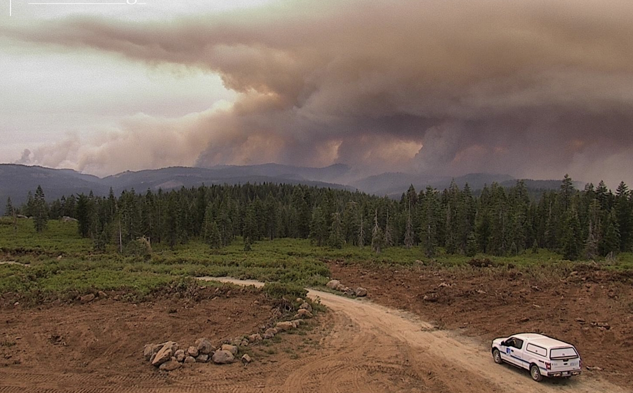
23 Likes
Many have wondered why this has spread so fast - slightly above normal temps (no big deal), normal RH, and unremarkable winds (15 to 20mph)
Last two fire seasons have been very slow. (so go easy with the climate change)
Maybe it has been the heat baking all the fuels and a very wet winter (high fuel load):
10 Likes
2 Likes
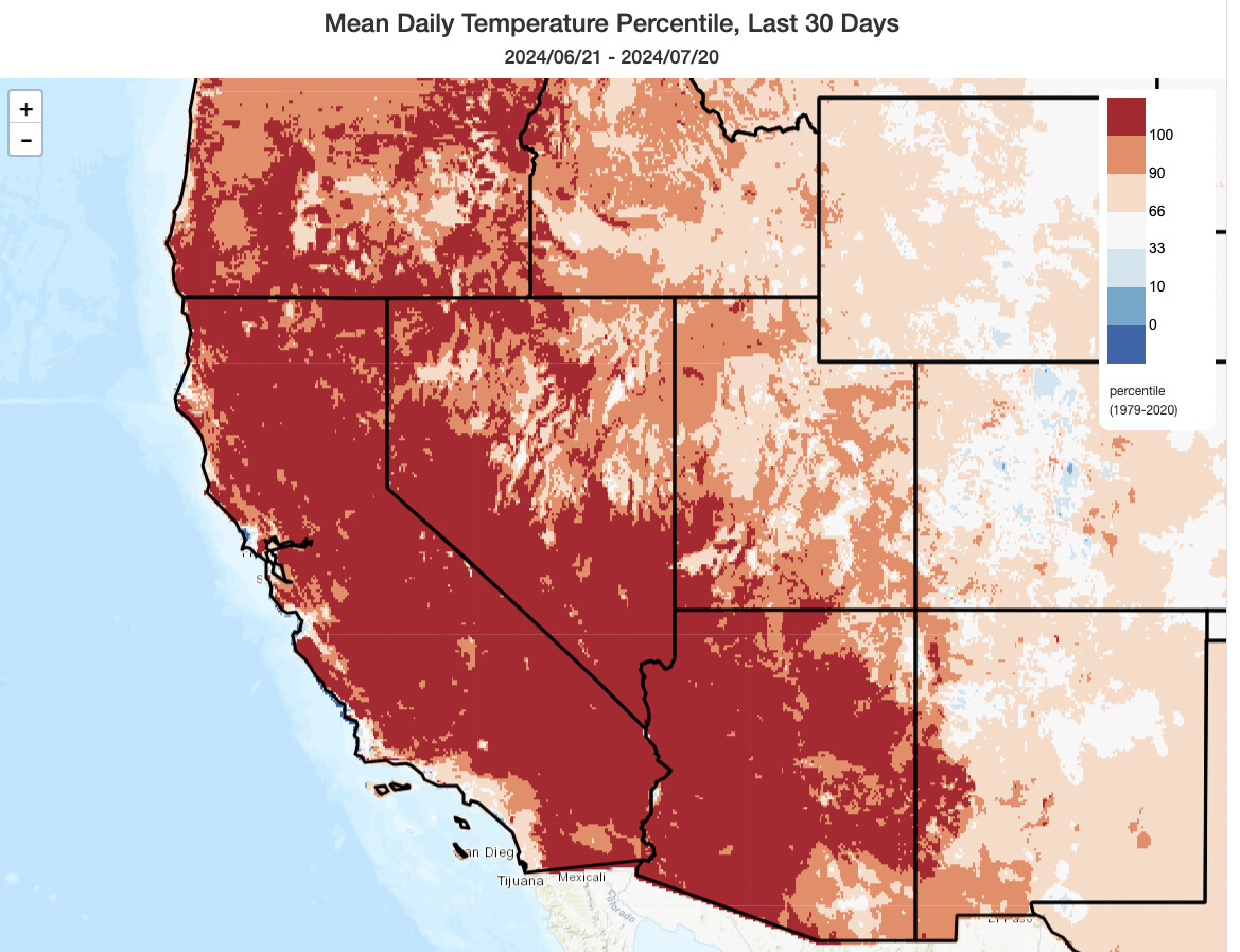
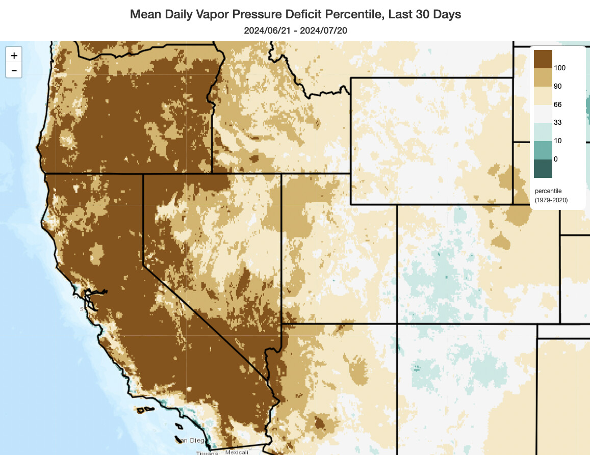
I don’t usually chime in here as often these days (very active elsewhere), but the recent sustained, extreme heat in the fire zone has been historic. The 30 days leading up to ignition were literally the hottest such 30 day period ever recorded in essentially the entire fire zone, and evaporative demand during that period was similarly anomalous. That, combined with the legacy of two consecutive wet winters (with an abundant grass/herbaceuous fuel crop), is an important consideration in what we’re seeing now.
In a warming California, our best understanding of hydroclimate change is that we will see increasing “whiplash” between wetter and drier conditions (driven in particular by heavier winter storms but more intensive summer/autumn evaporative losses), along with hotter temperatures. That is precisely what we have experienced this season.
32 Likes
And some receipts (this is via ClimateToolbox.org). These plots show the “rank” of 30 day temperatures through 7/20 and 30-day vapor pressure deficits through 7/20, respectively (everywhere in the “100th” percentile is the largest value on record).
17 Likes
Is there an IAP any where yet?
3 Likes
DIV H - south of 36 west side, fire is hung up a bit in the top of Salt Creek, below DeHaven Gulch. Tanker show in there going direct where they can to help tie this in to Hogsback. Meeker Creek, Mud Springs Plains. Sections 17, 20, 29 ish.
6 Likes
platte mtn and colby mtn cams down 
4 Likes
Anyone have any info on how Hwy 32 is holding? I see lots of helo’s on Flight Radar but can’t find any info on the area around Stagecoach or the Hwy further up where the line is downslope of the Hwy.
2 Likes
Fire encroached 32 near the cemetery but they’ve hammered it with copters all day and seem to have it managed. 32 has held so far.
3 Likes
What’s the problem then? Get out when you can.
I know the fire has burned up to 32 in multiple places. Sounds like Lomo and Forest Ranch took the brunt of it. There were some spot fires over 32, but crews quickly extinguished those. Currently there are water tenders staging in Butte Meadows with cops patrolling it which is a good sign.
4 Likes
Has anyone been out on the line and observed what kind of burn severity we are seeing here? My hope, especially with the rapid fire growth, is that we aren’t actually seeing total consumption of the larger fuels and conifer stands but rather a tremendous understory burn of massive proportions, like a so cal brush fire under the covers of a timber stand, and that the larger conifer stands actually have adequate moisture in them after back to back years of plentiful rain to hold off the fires intensity. If you watch the fire runs on the Cohasset, Pine Creek and East Los Molinos when they burned through the camera towers you’ll see fire consume all the ground fuels and creep up the timber but it doesn’t consume the foliage. Sure there’s going to be areas of total consumption but maybe/hopefully those are areas where there was a large amount of standing dead fuels and much larger brush components. While this fire is certainly going to result in another tragic outcome of residential losses which sucks and my heart breaks for those impacted, it may end up being a super beneficial fire for the ecosystems of the area. Just trying to see the glass half full.
8 Likes
After seeing the intensity of yesterdays run across to the North, that was hot and complete burn
4 Likes
ICYMI CalFire’s 1500 press brief 7/27

4 Likes
Between yesterday’s 30 mile long ice capped smoke column and the heat signatures being picked up via satellite we are talking about amounts of energy being released that are on par with low yield nuclear warheads… there will be random pockets where intensity was likely lower but overall I’d bet with confidence that the areas that burned yesterday are now moonscapes.
5 Likes