Looks like some thunderstorms in the forecast
2 Likes
3 Likes
This morning’s operational briefing had some useful info on work that’s been done recently and what’s planned for today (plus lots of acknowledgments that the weather is changing, the terrain is rough, there are going to be challenges, etc.)
For those most interested in what’s going on in and around deer creek canyon, the butte zone operations chief got into some pretty good detail. Link to timestamp:
Night ops, at the beginning of the stream, also gave some good info on current status. Day ops mostly focused on vagaries and an inspirational quote from Lou Holtz …
8 Likes
When the Park Fire pushed up out of Mud Creek into Cohasset, east of the Cohasset School, it ran into a large area of thinned forest on Maple Creek Ranch that has been prescribed burned over the past several years by volunteers from the Butte Prescribed Burn Association (Butte PBA). Here’s a video with some interview and footage from one of the PBA burns that happened here.
https://youtu.be/5mxouLPjOIA
18 Likes
Smoke looks like it is peeling out of the burn area about 6 hours ahead of where it was at yesterday. The fire didn’t push up much of a smoke column (no icecaps) until about 1800, yesterday.
10 Likes
Looks like Mill Creek and Deer Creek Canyon are starting to cook up a bit on the GOES satellite and Colby webcam.
7 Likes
100%, its running on them now. helco requested. couldnt get up early, now up.
2 Likes
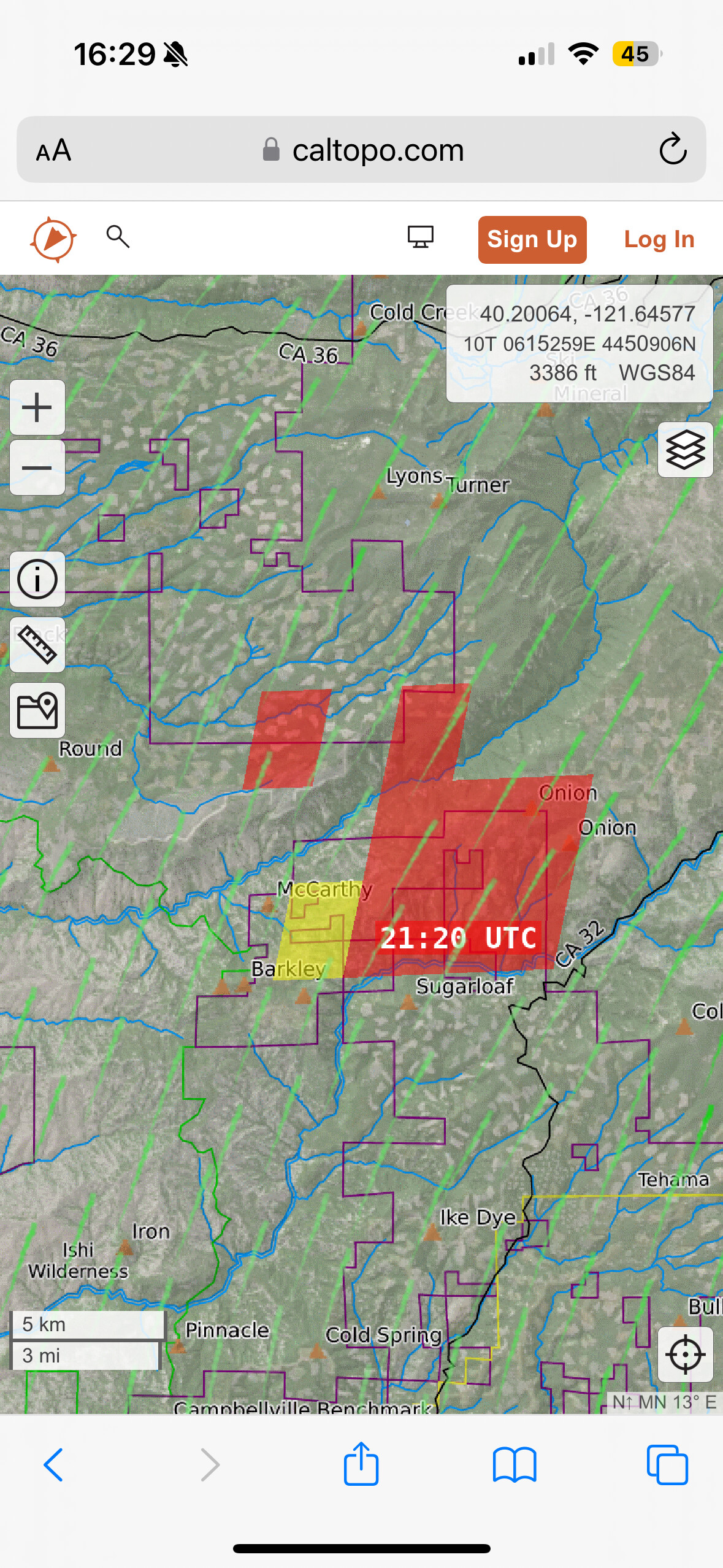
Fire making a run toward k line via scanner
7 Likes
3 Likes
K Line is the LNF 27N08 road that comes off 32 just north of Transfer, drops down into and crosses Deer Creek and connects up with the Lassen Trail (L Line) in between Deer and Mill Creek. I believe it’s running up Panther Cement and Dead Horse Creeks, Sec 13 and 14.
8 Likes
Thank you for information . It’s been a while since I worked in that area .
1 Like
Can somebody please get Mark Brunton to look at a map of Highway 32
4 Likes
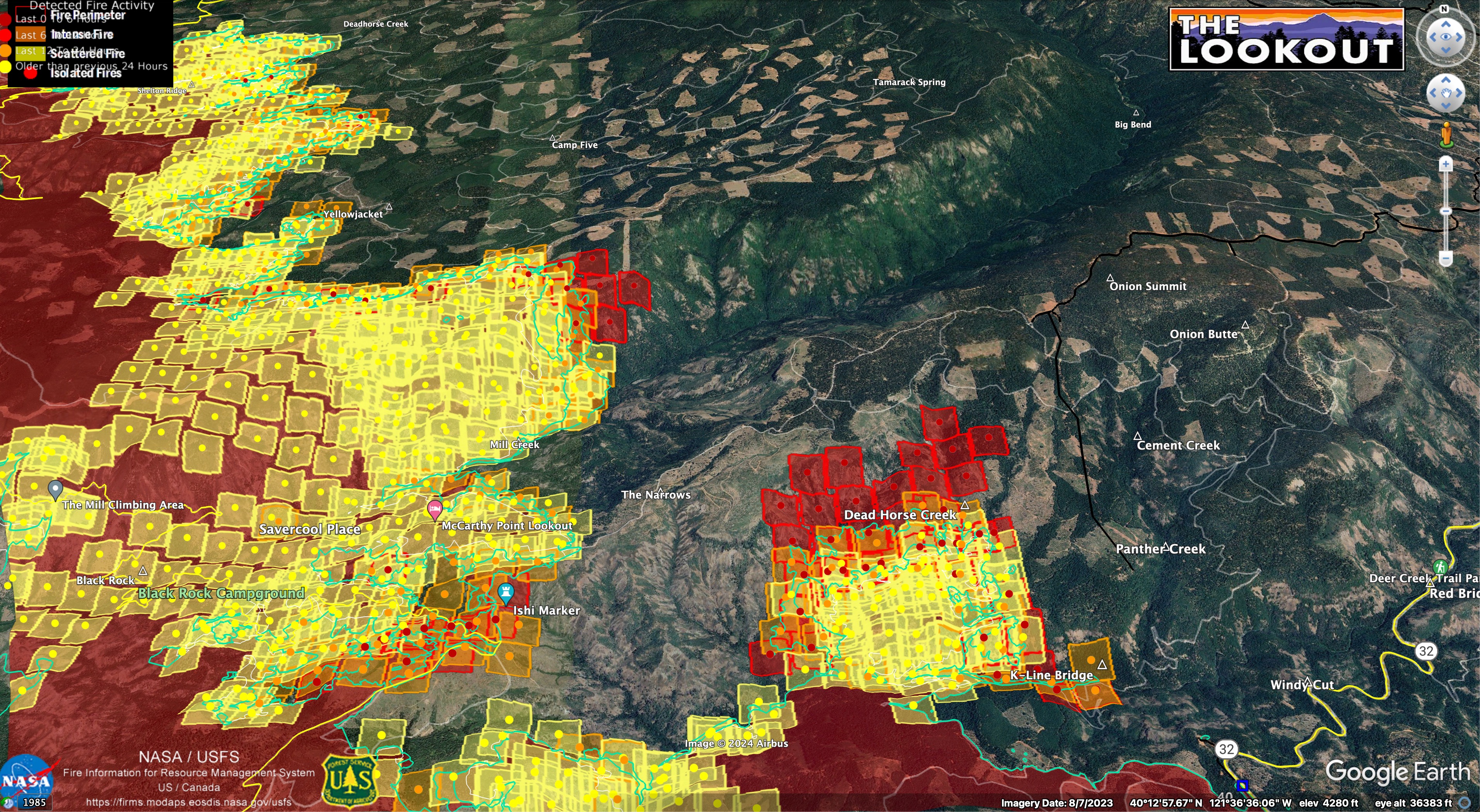
The perimeter shot at 1:30 this afternoon shows K line was fired down to Deer Creek last night (with the final piece down to the creek looking like a handline). Not a ton of depth but we’ll see if it can hold.
Across the creek, there is definitely a run in Dead Horse creek. FIRMS map does not show anything in Panther or Cement yet but I don’t know what the lag is on those satellite images. Map shows planned dozer line between the Dead Horse and Panther drainages (maybe it got done this morning?), and completed dozer line (tied in to handline across Deek Creek) upstream from Panther. All very difficult to hold I would imagine.
7 Likes
Throwing up some smoke today.
Cam…https://ops.alertcalifornia.org/cam-console/2588
4 Likes
Someone just ordered 6 miles of hose. Didn’t catch where it was going…
8 Likes
Is he not explaining the correct information? Surprised he’s still around…
1 Like
11 Likes
Impressive. Interested what this evening or tomorrow morning shows
1 Like
I heard DP 40
1 Like